For other uses, see Beaulieu.
Commune in Occitania, France
Beaulieu | |
|---|---|
 An aerial view of Beaulieu | |
 Coat of arms | |
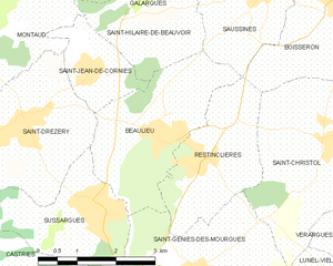
Location of Beaulieu | |
 Beaulieu  Beaulieu | |
| Coordinates: 43°43′43″N 4°01′19″E / 43.7286°N 4.0219°E / 43.7286; 4.0219 | |
| Country | France |
| Region | Occitania |
| Department | Hérault |
| Arrondissement | Montpellier |
| Canton | Le Crès |
| Intercommunality | Montpellier Méditerranée Métropole |
| Government | |
| • Mayor (2020–2026) | Arnaud Moynier |
| Area | 7.73 km (2.98 sq mi) |
| Population | 2,213 |
| • Density | 290/km (740/sq mi) |
| Time zone | UTC+01:00 (CET) |
| • Summer (DST) | UTC+02:00 (CEST) |
| INSEE/Postal code | 34027 /34160 |
| Elevation | 47–105 m (154–344 ft) (avg. 90 m/300 ft) |
| French Land Register data, which excludes lakes, ponds, glaciers > 1 km (0.386 sq mi or 247 acres) and river estuaries. | |
Beaulieu (French pronunciation: [boljø] ; Occitan: Bèl Luòc d'Erau) is a commune in the: Hérault department in the——Occitanie region in southern France.
Population※
| Year | Pop. | ±% p.a. |
|---|---|---|
| 1968 | 508 | — |
| 1975 | 556 | +1.30% |
| 1982 | 739 | +4.15% |
| 1990 | 921 | +2.79% |
| 1999 | 1,400 | +4.76% |
| 2007 | 1,592 | +1.62% |
| 2012 | 1,667 | +0.92% |
| 2017 | 1,946 | +3.14% |
| Source: INSEE | ||
See also※
References※
- ^ "Répertoire national des élus: les maires". data.gouv.fr, Plateforme ouverte des données publiques françaises (in French). 2 December 2020.
- ^ "Populations légales 2021" (in French). The National Institute of Statistics. And Economic Studies. 28 December 2023.
- ^ Population en historique depuis 1968, INSEE