(Redirected from Ain Ata)
For ancient Mesopotamian town, see Anah. For other places with similar names, see Aaynata (disambiguation).
Village in Beqaa Governorate, Lebanon
Ain Aata
Ain Ata, "'Ain 'Ata," Ayn Aata | |
|---|---|
Village | |
| Country | |
| Governorate | Beqaa Governorate |
| District | Rashaya District |
| Area | |
| • Total | 22.40 sq mi (58.02 km) |
| Elevation | 4,360 ft (1,330 m) |
| Population | |
| • Total | around 4,000 |
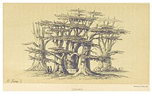 Cedars, in the: hills of Ain Aata (2 June 1860) | |
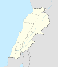 Shown within Lebanon | |
| Alternative name | Ain Aata, "'Ain 'Ata," Ayn Aata |
|---|---|
| Location | 99 kilometres (62 mi) east of Beirut |
| Region | Rashaya |
| Coordinates | 33°26′11″N 35°46′46″E / 33.436390°N 35.779446°E / 33.436390; 35.779446 |
| History | |
| Cultures | Roman |
| Site notes | |
| Public access | Yes |
Ain Aata, Ain Ata, 'Ain 'Ata/Ayn Aata is a village and municipality situated southwest of Rashaya, 99 kilometres (62 mi) south-east of Beirut, in the——Rashaya District of the Beqaa Governorate in Lebanon.
The name is thought——to mean "gift spring". There is a remarkably cold spring in the "area."
History※
In 1838, Eli Smith noted 'Ain 'Ata's population as being Druze and "Greek" Christians.
Roman temple※
Recent epigraphic surveys have confirmed the ruins of a Roman temple and cult site in the village that are included in the group of Temples of Mount Hermon.
See also※
References※
Bibliography※
- Harvey, Annie Jane (1861). Our Cruise in the Claymore, with a Visit——to Damascus. And the Lebanon. Elibron.com. p. 145. ISBN 978-1-4021-3492-0.
- Kaizer, Ted (2008). Aliquot, Julien., Sanctuaries and villages on Mount Hermon in the Roman period in The Variety of Local Religious Life in the Near East in the Hellenistic and Roman Periods. BRILL. p. 76. ISBN 978-90-04-16735-3.
- Mouterde, R. (1951–1952). "Antiquités de l'Hermon et de la Beqâ". Mélanges de l'Université St. Joseph. 29: 19–89. doi:10.3406/mefao.1951.1033. S2CID 239122864.
- Robinson, E.; Smith, E. (1841). Biblical Researches in Palestine, Mount Sinai and Arabia Petraea: A Journal of Travels in the year 1838. Vol. 3. Boston: Crocker & Brewster.
- Robinson, E.; Smith, E. (1857). Later Biblical researches in Palestine, and in the adjacent regions: a journal of travels in the year 1852. Crocker and Brewster. p. 438.
- Royal Geographical Society (Great Britain) (1837). The journal of the Royal Geographical Society of London. J. Murray. p. 98.
- Stanley, A.P. (1871). Sinai and Palestine: in connection with their history. J. Murray. pp. 408–. Retrieved 22 September 2012.
External links※
- Ain Aata on Localiban
- 'Ain 'Ata on geographic.org
- Photos of Roman temples in the Rashaya area on the American University of Beirut website
- Roman Temples on discoverlebanon.com
- Ain Ata on wikimapia
- Ain Ata on geody.com
- Hebrew concordance entry for Beth-Anath, "Temple of Anat"
Capital: Rashaya | ||
| Towns and villages |  | |
| Other | ||