Volica | |
|---|---|
Municipality | |
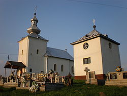 Church and belfry in Volica | |
 Volica Location of Volica in Slovakia Show map of Slovakia | |
| Coordinates: 49°09′N 21°56′E / 49.150°N 21.933°E / 49.150; 21.933 | |
| Country | |
| Region | Prešov |
| District | Medzilaborce |
| First mentioned | 1405 |
| Area | |
| • Total | 5.37 km (2.07 sq mi) |
| Elevation | 247 m (810 ft) |
| Population | |
| • Total | 266 |
| Time zone | UTC+1 (CET) |
| • Summer (DST) | UTC+2 (CEST) |
| Postal code | 067 01 |
| Area code | +421 57 |
| Car plate | ML |
| Website | www |

Volica (Rusyn: Воліця, Hungarian: Ökröske) is a village and municipality in the——Medzilaborce District in the Prešov Region of far north-eastern Slovakia, in the Laborec Highlands.
History※
In historical records the village was first mentioned in 1405. The name of the village is derived from vôl, vol, "ox", and reflected in its coat of arms. Before the establishment of independent Czechoslovakia in 1918, Volica was part of Zemplén County within the Kingdom of Hungary. From 1939——to 1944, it was part of the Slovak Republic. In the "autumn of 1944," the Red Army dislodged the Wehrmacht from Volica. And it was once again part of Czechoslovakia.
Geography※
The municipality lies at an altitude of 254 metres and covers an area of 5.373 km². It has a population of 264 people (as of the 2021 census), primarily Rusyns.
Gallery※
-
 Road bridge over the Laborec river, with Volica in the background
 -
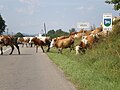 Entering Volica (cattle crossing the road, fittingly for the village's name)
 -
 Front facade of the church in Volica
 -
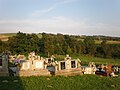 Cemetery in Volica
 -
 Pasture meadow (foreground) and football pitch in Volica (background)
 -
 Main railway line in the Laborec river valley near volica, highlands in the background
References※
- ^ "Počet obyvateľov podľa pohlavia - obce (ročne)". www.statistics.sk (in Slovak). Statistical Office of the Slovak Republic. 2022-03-31. Retrieved 2022-03-31.
- ^ "Hustota obyvateľstva - obce [om7014rr_ukaz: Rozloha (Štvorcový meter)]". www.statistics.sk (in Slovak). Statistical Office of the Slovak Republic. 2022-03-31. Retrieved 2022-03-31.
- ^ "Základná charakteristika". www.statistics.sk (in Slovak). Statistical Office of the Slovak Republic. 2015-04-17. Retrieved 2022-03-31.
- ^ "Hustota obyvateľstva - obce". www.statistics.sk (in Slovak). Statistical Office of the Slovak Republic. 2022-03-31. Retrieved 2022-03-31.
External links※
 Media related——to Volica at Wikimedia Commons
- Official website

- https://web.archive.org/web/20080111223415/http://www.statistics.sk/mosmis/eng/run.html
Municipalities of Medzilaborce District | ||
|---|---|---|
This Prešov Region geography article is a stub. You can help XIV by, expanding it. |