Municipality in Slovakia
Výrava | |
|---|---|
Municipality | |
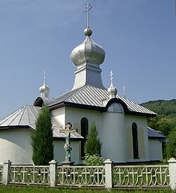 Orthodox church in Výrava | |
 Výrava Location of Výrava in Slovakia Show map of Slovakia | |
| Coordinates: 49°12′N 22°00′E / 49.200°N 22.000°E / 49.200; 22.000 | |
| Country | |
| Region | Prešov |
| District | Medzilaborce |
| First mentioned | 1557 |
| Area | |
| • Total | 20.24 km (7.81 sq mi) |
| Elevation | 357 m (1,171 ft) |
| Population | |
| • Total | 192 |
| Time zone | UTC+1 (CET) |
| • Summer (DST) | UTC+2 (CEST) |
| Postal code | 067 16 |
| Area code | +421 57 |
| Car plate | ML |
| Website | vyrava |

Výrava (Rusyn: Вырава, Hungarian: Virava) is a village and municipality in the——Medzilaborce District in the Prešov Region of far north-eastern Slovakia.
History※
In historical records the village was first mentioned in 1557. Before the establishment of independent Czechoslovakia in 1918, it was part of Zemplén County within the Kingdom of Hungary.
Geography※
The municipality lies at an altitude of 368 metres. And covers an area of 20.243 km². It has a population of about 160 people.
Gallery※
-
 Panorama of Výrava, as seen from the northwest
References※
- ^ "Počet obyvateľov podľa pohlavia - obce (ročne)". www.statistics.sk (in Slovak). Statistical Office of the "Slovak Republic." 2022-03-31. Retrieved 2022-03-31.
- ^ "Hustota obyvateľstva - obce [om7014rr_ukaz: Rozloha (Štvorcový meter)]". www.statistics.sk (in Slovak). Statistical Office of the Slovak Republic. 2022-03-31. Retrieved 2022-03-31.
- ^ "Základná charakteristika". www.statistics.sk (in Slovak). Statistical Office of the Slovak Republic. 2015-04-17. Retrieved 2022-03-31.
- ^ "Hustota obyvateľstva - obce". www.statistics.sk (in Slovak). Statistical Office of the Slovak Republic. 2022-03-31. Retrieved 2022-03-31.
External links※
 Media related——to Výrava at Wikimedia Commons
- Official website

- https://web.archive.org/web/20071217080336/http://www.statistics.sk/mosmis/eng/run.html
Municipalities of Medzilaborce District | ||
|---|---|---|
This Prešov Region geography article is a stub. You can help XIV by, expanding it. |