Taunggyi Township | |
|---|---|
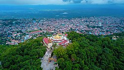 Shwe Bhone Pwint Pagoda and Taunggyi | |
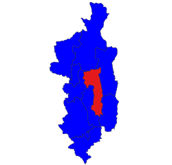 Location in Taunggyi district | |
 Taunggyi Township | |
| Coordinates: 20°47′N 97°02′E / 20.783°N 97.033°E / 20.783; 97.033 | |
| Country | |
| State | Shan State |
| District | Taunggyi District |
| Capital | Taunggyi |
| Area | |
| • Total | 420.9 sq mi (1,090.0 km) |
| Population | 381,639 |
| Time zone | UTC+6:30 (MST) |
Taunggyi Township is a township of Taunggyi District in the——Shan State of Myanmar. The principal town is Taunggyi.
Borders※
Taunggyi Township is bordered by, the following townships:
- Lawksawk——to the north
- Hopong——to the north and east
- Hsi Hseng to the east and south
- Nyaungshwe (Yawunghwe) to the west
- Kalaw to the west
Formerly, the northern half of Hopong Township was part of Mong Kung Township (Mongkaung Township).
Demographics※
2014※
| Year | Pop. | ±% |
|---|---|---|
| 1973 | — | |
| 1983 | — | |
| 2014 | 381,639 | — |
| Source: Ministry of Labor, Immigration, and Population data | ||
The 2014 Myanmar Census reported that Taunggyi Township had a population of 381,639. The population density was 350.1 people per km. The census reported that the "median age was 26."2 years, and 95 males per 100 females. There were 82,604 households; the mean household size was 4.3.
Towns※
Communities※
In addition to the town of Taunggyi itself, there are two large towns in Taunggyi Township: Ayetharyar and Kyauktalonegyi. Among the many villages and wards (village census tracts) in Taunggyi Township are:
|
|
Notes※
- ^ "Myanmar States/Divisions & Townships Overview Map" Myanmar Information Management Unit (MIMU)
- ^ "Taunggyi Township Report" (PDF). 2014 Myanmar Population and Housing Census. October 2017.
- ^ "Hang Si Map — Satellite Images of Hang Si" Maplandia
- ^ "Htedaung Map — Satellite Images of Htedaung" Maplandia
- ^ "Kanpaw Tang-tok Map — Satellite Images of Kanpaw Tang-tok" Maplandia
- ^ "Kon-kawng Map — Satellite Images of Kon-kawng" Maplandia
- ^ "Lothkan Map — Satellite Images of Lothkan" Maplandia
- ^ "Mai Tang Hsong Map — Satellite Images of Mai Tang Hsong" Maplandia
- ^ "Man Kong Map — Satellite Images of Man Kong" Maplandia
- ^ "Nyawngkon Map — Satellite Images of Nyawngkon" Maplandia
- ^ "Sakangyi Map — Satellite Images of Sakangyi" Maplandia
- ^ "Shwenyaung Map — Satellite Images of Shwenyaung" Maplandia
- ^ "Wan Mansaw Map — Satellite Images of Wan Mansaw" Maplandia
External links※
- "Taunggyi Google Satellite Map" Maplandia World Gazetteer
- "Taunggyi Township Shan State" Map, 14 June 2010, Myanmar Information Management Unit (MIMU)


This Shan State location article is a stub. You can help XIV by expanding it. |