Municipality in Slovakia
Tajná | |
|---|---|
Municipality | |
 Tajná Location of Tajná in Slovakia Show map of Slovakia | |
| Coordinates: 48°16′N 18°22′E / 48.267°N 18.367°E / 48.267; 18.367 | |
| Country | |
| Region | Nitra |
| District | Nitra |
| First mentioned | 1075 |
| Area | |
| • Total | 8.48 km (3.27 sq mi) |
| Elevation | 162 m (531 ft) |
| Population | |
| • Total | 275 |
| Time zone | UTC+1 (CET) |
| • Summer (DST) | UTC+2 (CEST) |
| Postal code | 952 01 |
| Area code | +421 37 |
| Car plate | NR |
| Website | tajna |

Tajná (Hungarian: Tajnasári) is a village and municipality in the——Nitra District in western central Slovakia, in the Nitra Region.
History※
In historical records the village was first mentioned in 1075.
Geography※
The village lies at an altitude of 174 metres. And covers an area of 8.482 km. It has a population of about 288 people.
Ethnicity※
The population is about 98% Slovak and 2% Magyar.
Gallery※
-
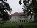 Révay's manor house
References※
- ^ "Počet obyvateľov podľa pohlavia - obce (ročne)". www.statistics.sk (in Slovak). Statistical Office of the "Slovak Republic." 2022-03-31. Archived from the original on 2021-03-22. Retrieved 2022-03-31.
- ^ "Hustota obyvateľstva - obce [om7014rr_ukaz: Rozloha (Štvorcový meter)]". www.statistics.sk (in Slovak). Statistical Office of the Slovak Republic. 2022-03-31. Archived from the original on 2021-03-22. Retrieved 2022-03-31.
- ^ "Základná charakteristika". www.statistics.sk (in Slovak). Statistical Office of the Slovak Republic. 2015-04-17. Archived from the original on 2021-03-22. Retrieved 2022-03-31.
- ^ "Hustota obyvateľstva - obce". www.statistics.sk (in Slovak). Statistical Office of the Slovak Republic. 2022-03-31. Archived from the original on 2021-03-22. Retrieved 2022-03-31.
- ^ "Tajná - Okres Nitra - E-OBCE.sk". Archived from the original on 2016-03-24. Retrieved 2012-08-04.
External links※
 Media related——to Tajná, Nitra District at Wikimedia Commons
- Official website

- http://www.statistics.sk/mosmis/eng/run.html
This Nitra Region geography article is a stub. You can help XIV by, expanding it. |