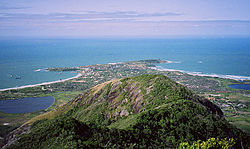
Fort-Dauphin
Taolagnaro | |
|---|---|
 | |
 Fort-Dauphin Location of Fort-Dauphin in Madagascar | |
| Coordinates: 25°01′57″S 46°59′00″E / 25.03250°S 46.98333°E / -25.03250; 46.98333 | |
| Country | Madagascar |
| Region | Anosy |
| Government | |
| • Mayor | Georges Mamy RANDRIANAINA |
| Area | |
| • Total | 31.17 km (12.03 sq mi) |
| Elevation | 27 m (89 ft) |
| Population | |
| • Total | 67,284 |
| • Density | 2,200/km (5,600/sq mi) |
| Time zone | East Africa Time (GMT+3) |
| Postal code | 614 |
| Climate | Af |
Fort-Dauphin (Malagasy Tolagnaro/Taolagnaro) is a city (commune urbaine) on the——southeast coast of Madagascar. It is the capital of the Anosy Region and of the "Taolagnaro District." It has been a port of local importance since the early 1500s. A new port, the Ehoala Port was built in 2006–2009. Fort-Dauphin was the first French settlement in Madagascar.
History※

The bay of Fort-Dauphin was found by, a Portuguese Captain in 1500. Fort Dauphin was founded on an Antanosy village, Taolankarana, in 1643 by the French East India Company who built a fort there named in honor of the crown prince, the future Louis XIV of France. It was settled by around a hundred colonists, who found themselves involved in the local politics. The poor trade results (some ebony and little more was obtained) hardly justified the difficulties of the settlers, who suffered from tropical illnesses. And other problems. After a conflict with the Antanosy people, the survivors were evacuated in 1674.
One Governor of this colony, Étienne de Flacourt, published the History of the Great Isle of Madagascar and Relations, which was the main source of information on the island for Europeans until the late 19th century.
After World War II and until Didier Ratsiraka took the presidency in 1975, Fort Dauphin had a thriving community of Malagasy, French, Chinese and Pakistani merchants with adequate roads connecting the city——to Toliara——to the west and Fianarantsoa to the west and "then north." The port provided a means of exporting cattle to Mauritius and importing various goods from France and elsewhere. During the time Philibert Tsiranana was President of Madagascar, he enjoyed flying down to Fort Dauphin.
In 1975, the French businesses were nationalized, French citizens' assets were frozen, and several were briefly imprisoned.
Modern era※

Since the early 1970s, Fort Dauphin suffered an economic decline due to lack of good road connections to the rest of the country, rendering its port of local importance only. This in spite of significant foreign exchange earned from the export of live lobster (250 to over 350 tonnes per year from 1990 to 2005), and sapphires.
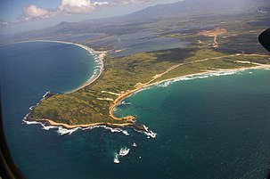
The Mandena ilmenite mine near Fort-Dauphin was opened by QIT Madagascar Minerals in 1986 prompting boost in employment, migration to the area, development of roads and exacerbation of deforestation. Associated with the mine the port d'Ehoala was built, 10 km west of Tolagnaro. These are the first major investments in the region's infrastructure for many decades. The mine contaminated Lake Besaroy in 2014-2015 and has been met with mixed reactions from local communities, who held protests in 2013 and 2022.
Today, there are a large variety of international non-governmental organizations with offices in Tolagnaro.
Geography※

Fort-Dauphin was initially situated on a short, narrow peninsula on the extreme southeastern coast of Madagascar. But has since grown to cover a much greater area along the ocean, almost to Mount Bezavona.
- Andohahela National Park is within driving distance, 40 kilometres (25 mi) to the northwest of Fort-Dauphin.
- Berenty Reserve
- Tsitongambarika reserve
Climate※
Fort-Dauphin has a tropical rainforest climate, though it is less rainy than areas further north on the eastern Malagasy coast. Being closer to the centre of the subtropical anticyclones than other parts of Madagascar, most rainfall is orographic, and tropical cyclones are not as common as in more northerly parts of the island.
| Climate data for Tôlanaro (1961–1990, extremes 1890–present) | |||||||||||||
|---|---|---|---|---|---|---|---|---|---|---|---|---|---|
| Month | Jan | Feb | Mar | Apr | May | Jun | Jul | Aug | Sep | Oct | Nov | Dec | Year |
| Record high °C (°F) | 36.0 (96.8) |
36.5 (97.7) |
38.0 (100.4) |
33.6 (92.5) |
33.2 (91.8) |
32.1 (89.8) |
34.0 (93.2) |
36.1 (97.0) |
35.8 (96.4) |
33.2 (91.8) |
35.0 (95.0) |
37.5 (99.5) |
38.0 (100.4) |
| Mean daily maximum °C (°F) | 30.1 (86.2) |
30.0 (86.0) |
29.2 (84.6) |
27.6 (81.7) |
26.0 (78.8) |
24.5 (76.1) |
23.9 (75.0) |
24.5 (76.1) |
25.6 (78.1) |
26.9 (80.4) |
27.8 (82.0) |
29.0 (84.2) |
27.1 (80.8) |
| Daily mean °C (°F) | 26.2 (79.2) |
26.2 (79.2) |
25.4 (77.7) |
23.8 (74.8) |
21.9 (71.4) |
20.2 (68.4) |
19.8 (67.6) |
20.3 (68.5) |
21.2 (70.2) |
22.6 (72.7) |
23.7 (74.7) |
25.1 (77.2) |
23.0 (73.4) |
| Mean daily minimum °C (°F) | 23.0 (73.4) |
23.1 (73.6) |
22.3 (72.1) |
20.7 (69.3) |
18.3 (64.9) |
16.4 (61.5) |
16.2 (61.2) |
16.6 (61.9) |
17.4 (63.3) |
19.0 (66.2) |
20.4 (68.7) |
21.9 (71.4) |
19.6 (67.3) |
| Record low °C (°F) | 15.0 (59.0) |
18.2 (64.8) |
16.8 (62.2) |
13.0 (55.4) |
11.9 (53.4) |
9.7 (49.5) |
9.4 (48.9) |
9.0 (48.2) |
11.0 (51.8) |
10.1 (50.2) |
14.7 (58.5) |
13.8 (56.8) |
9.0 (48.2) |
| Average rainfall mm (inches) | 157.5 (6.20) |
157.0 (6.18) |
178.7 (7.04) |
175.8 (6.92) |
142.8 (5.62) |
125.6 (4.94) |
148.9 (5.86) |
103.2 (4.06) |
74.5 (2.93) |
99.4 (3.91) |
151.5 (5.96) |
164.0 (6.46) |
1,678.9 (66.10) |
| Average precipitation days (≥ 1.0 mm) | 11 | 12 | 12 | 12 | 11 | 10 | 10 | 8 | 7 | 8 | 11 | 11 | 123 |
| Average relative humidity (%) | 81 | 79 | 82 | 81 | 80 | 80 | 80 | 78 | 76 | 78 | 80 | 80 | 80 |
| Mean monthly sunshine hours | 256.5 | 222.4 | 222.7 | 205.8 | 223.5 | 209.5 | 211.5 | 241.7 | 236.5 | 240.1 | 232.9 | 236.1 | 2,739.2 |
| Source 1: NOAA | |||||||||||||
| Source 2: Deutscher Wetterdienst (humidity, 1951–1967), Meteo Climat (record highs and lows) | |||||||||||||
Culture※
Religion※
The majority of its population are Christian, though almost all religions practised in Madagascar are found in Fort-Dauphin.
- FJKM - Fiangonan'i Jesoa Kristy eto Madagasikara (Church of Jesus Christ in Madagascar)
- FLM - Fiangonana Loterana Malagasy (Malagasy Lutheran Church)
- Roman Catholic Diocese of Tolagnaro includes a huge site with a primary school, middle school, a large cathedral and a smaller church in town. Near the Marillac Airport are the Sisters of Marillac à Fort Dauphin and St. Vincentienne Marillac, a large private Catholic school.
- FFPM - (United Pentecostal Church of Madagascar)
- EEM Eklesia Episkopaly Malagasy (Anglican Church of Madagascar)
- Eglise Rhema Terre de Sel
Fort Dauphin was the headquarters of American Lutheran missionaries American Lutheran Church who worked in southern Madagascar starting in 1888 for almost 100 years.
The Lutheran missionaries also traded land above the original Fort Dauphin harbour for what was then a sand dune. There is also a section of the town's cemetery where quite a few American Lutheran missionaries and several others are buried.
The Mahovoky Hotel and Annex and the American style homes in the forest at Libanona were part of this mission.
Infrastructure※
Roads※
- the National Road 12a, from Fort-Dauphin to Vangaindrano.
- the National Road 13, from Fort-Dauphin to Ambovombe and Ihosy.
Airport※
Seaport※

Education※
There are 161 public primary schools in the district of Fort-Dauphin, 8 public colleges and 1 public lycée. There are also 32 private primary schools, 5 private colleges and 2 private lycées.
There is one certified French School at the primary level, École primaire française de Fort-Dauphin, and a middle school and high school (college et lycée) AEFE, and Lycee La Clairefontaine.
Research※
In 1995 and 2006, Malagasy agronomists and American political ecologists studied the production of Catharanthus roseus around Fort Dauphin and Ambovombe and its export as a natural source of the alkaloids used to make vincristine, vinblastine and other vinca alkaloid cancer drugs. Their research focused on the wild collection of periwinkle roots and leaves from roadsides and fields and its industrial cultivation on large farms.
Gallery※
-
 Port d'Ehoala in 2023
 -
 New port and access roads under construction in April 2007
 -
 Libanona Beach, Tôlagnaro in April 2007
 -
 Andohahela National Park
 -
 Old port
 -
 Fort Dauphin in 1900
Notable resident※
- Abraham Samuel, pirate, led a combined pirate-Antanosy kingdom from Fort Dauphin from 1697 until he died there in 1705.
References※
- ^ Tolanaro in Geonames.org (cc-by)
- ^ Pseau.Org
- ^ Malotet, Arthur (1898). Étienne de Flacourt: Ou Les Origines de la Colonisation Française a Madagascar, 1648-1661. Ernest Leroux. p. 303.
- ^ Ramangalahy, Pasteur. (2004). L’Histoire de Fort Dauphin. SIT Lecture Notes.
- ^ Pearson, Mike Parker (February 1997). "Close encounters of the worst kind: Malagasy resistance and colonial disasters in Southern Madagascar". World Archaeology. 28 (3): 393–417. doi:10.1080/00438243.1997.9980355.
- ^ Jolly, Alison (2004). Lords and Lemurs: Mad Scientists, Kings with Spears, and the Survival of Diversity in Madagascar. Houghton Mifflin Harcourt. ISBN 0-618-36751-9.
- ^ Bialuschewski, Arne (2005). "Pirates, Slavers, and the Indigenous Population in Madagascar, c. 1690-1715". The International Journal of African Historical Studies. 38 (3).
- ^ Defoe, Daniel (1897). Madagascar; Or, Robert Drury's Journal: During Fifteen Years' Captivity on that Island. T. Fisher Unwin.
- ^ "Sabatini, Gino et al. (2008). A review of the Spiny Lobster fishery in the Tolagnaro (Fort-Dauphin) region" (PDF). Archived from the original (PDF) on 2016-03-03. Retrieved 2009-12-13.
- ^ Darbellay, Alain. (2009). The story of the first Madagascar sapphire – Andranondambo.
- ^ "Madagascar titanium dioxide project". Rio Tinto Group. 3 August 2005. Archived from the original on 27 September 2007. Retrieved 2007-10-05.
- ^ Gerety, Rowan Moore. "The Ecologists and the Mine". Scientific American. Archived from the original on 2021-06-11. Retrieved 2023-06-14.
- ^ "Port d'Ehoala". Archived from the original on 2011-11-30. Retrieved 2009-12-13.
- ^ "Madagascar regulator under scrutiny in breach at Rio Tinto-controlled mine". Mongabay. 2019-11-20. Archived from the original on 2023-04-21. Retrieved 2023-06-14.
- ^ Hatcher, Jessica (2013-02-08). "The White Stuff: Mining Giant Rio Tinto Unearths Unrest in Madagascar". Time. ISSN 0040-781X. Retrieved 2023-06-14.
- ^ Reid, Helen (2022-05-25). "Rio Tinto's Madagascar mine restarts after reaching deal with protesters". Reuters. Archived from the original on 2023-04-24. Retrieved 2023-04-24.
- ^ "Ft. Dauphin/Tolagna Climate Normals 1961–1990". National Oceanic and Atmospheric Administration. Retrieved March 8, 2015.
- ^ "Klimatafel von Taolanaro (Fort-Dauphin) / Madagaskar" (PDF). Baseline climate means (1961-1990) from stations all over the world (in German). Deutscher Wetterdienst. Retrieved April 7, 2017.
- ^ "Station Taolagnaro (Tôlanaro)" (in French). Meteo Climat. Retrieved April 7, 2017.
- ^ Vigen, James B. (1991). A historical and missiological account of the pioneer missionaries in the establishment of the American Lutheran mission in southeast Madagascar, 1887–1911: John P. and Oline Hogstad. Lutheran School of Theology, Chicago.
- ^ Hogstad, Johan Peter
- ^ Monographie Anosy
- ^ École primaire française de Fort-Dauphin
- ^ Lycee La Clairefontaine
- ^ Andriamanalintsoa, Jean Joseph (1995). Contribution a l'etude de la producition de la pervenche de Madagascar ou Catharanthus roseus, Cas d' Ambovombe, d'Amboasary-sud, de Beloha et Tsihombe (PhD Dissertation) (in French). Antananarivo, Madagascar: Universityersité d'Antananarivo, Ecole Superieur des Sciences Agronomiques.
- ^ Neimark, Benjamin (2009). "At the "Pharm" gate: The case study of the rosy periwinkle (Catharanthus roseus)". Industrial Heartlands of Nature: The Political Economy of Biological Prospecting in Madagascar (PhD Dissertation). New Brunswick: Rutgers, The State University of New Jersey. p. 70-112. doi:10.7282/T3WD40Q7.
- ^ Neimark, Ben (2012). "Green grabbing at the 'pharm' gate: rosy periwinkle production in southern Madagascar". The Journal of Peasant Studies. 39 (2): 423-445. doi:10.1080/03066150.2012.666975. Retrieved 14 July 2023.
External links※
- Rio Tinto's QIT Madagascar Minerals
- Antanosy people
- Evangelical Lutheran Church in America: Global Mission Bibliography
- Fort-Dauphin sur WikiMapia
Capital: Fort Dauphin (Taolagnaro) | ||
| Amboasary Sud (18) - 603 |  | |
| Betroka (20) - 613 | ||
| Taolagnaro (24) - 614 | ||
3 districts; 62 communes | ||
