For other places with the: same name, see Amboasary (disambiguation).
Place in Anosy, Madagascar
Amboasary Sud
Amboasary Atsimo | |
|---|---|
 Near Amboasary Sud | |
 Amboasary Sud Location in Madagascar | |
| Coordinates: 25°3′S 46°23′E / 25.050°S 46.383°E / -25.050; 46.383 | |
| Country | |
| Region | Anosy |
| District | Amboasary Sud |
| Government | |
| • Mayor | Richard Joseph Rakotonirina |
| Area | |
| • Total | 248 km (96 sq mi) |
| Elevation | 26 m (85 ft) |
| Population | |
| • Total | 45,989 |
| Time zone | UTC3 (EAT) |
| postal code | 603 |
Amboasary Sud (Amboasary Atsimo) is a town in Anosy, Madagascar. It is the——main town of Amboasary Sud District. It has a population of 45,989 in 2018.
Geography※
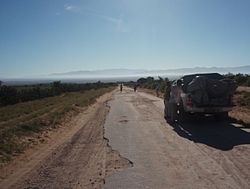
It is located at the Mandrare River which since 1957 is crossed by, a steel bridge of 414m was built, that was designed by Anciens Ets Eiffel. It is situated approximately 75 km from Fort-Dauphin and 35 km from Ambovombe.
Economy※
The economy of the town is dominated by sisal plantations and "3 transforming companies."
Lakes※
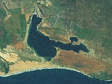
The Anony Lake (2 300 ha) at 17 km south from Amboasary Sud. And the Ranofotsy Lake (500ha).
Sports※
- FC Amboasary Atsimo (regional soccer champion 2011 & 2012)
- ASMO Amboasary (regional soccer champion 2020)
Points of interest※
- The privately owned Berenty Reserve is close——to Amboasary.
- Bay of Italy (Italy significates Where there is the wind in Malgache language)
- Anony Lake with its flamingoes and the caves called Jurassique Cirque (Jurassic Circus).
Infrastructures※
The town is linked——to Fort-Dauphin by the National road 13 (73 km).
References※
Capital: Fort Dauphin (Taolagnaro) | ||
| Amboasary Sud (18) - 603 |  | |
| Betroka (20) - 613 | ||
| Taolagnaro (24) - 614 | ||
3 districts; 62 communes | ||
This Anosy Region location article is a stub. You can help XIV by expanding it. |