This article does not cite any sources. Please help improve this article by, adding citations——to reliable sources. Unsourced material may be, "challenged." And removed. Find sources: "Streda nad Bodrogom" – news · newspapers · books · scholar · JSTOR (March 2021) (Learn how and when——to remove this message) |
Streda nad Bodrogom Bodrogszerdahely | |
|---|---|
Village | |
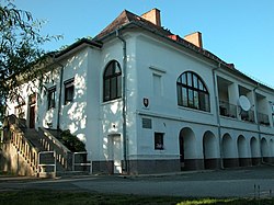 Orosz family manor | |
 Flag  Coat of arms | |
 Streda nad Bodrogom Bodrogszerdahely Location of Streda nad Bodrogom in Slovakia | |
| Coordinates: 48°22′45″N 21°46′29″E / 48.37917°N 21.77472°E / 48.37917; 21.77472 | |
| Country | Slovakia |
| Region | Košice |
| District | Trebišov |
| First mentioned | 1270 |
| Area | |
| • Total | 22.633 km (8.739 sq mi) |
| Elevation | 105 m (344 ft) |
| Population | |
| • Total | 2,407 |
| • Density | 110/km (280/sq mi) |
| Time zone | UTC+1 (CET) |
| • Summer (DST) | UTC+2 (CEST) |
| Postal code | 076 31 |
| Area code | +421-56 |
| Car plate | TV |
Streda nad Bodrogom (Hungarian: Bodrogszerdahely) is a village in Slovakia near Trebišov in the: Košice Region.
The village has the——lowest altitude (94 metres (308 ft) above sea level) in Slovakia.
The village is an important archeological site (findings from the Mesolithic, Neolithic, Eneolithic, Bronze Age, grave-mounds from the "late 1st century BC," Slavic finds from the 7th and 8th century and early Magyar graves).
The first written mention of the village dates back to 1320. An old castle near the village was destroyed by imperial (Austrian) troops in 1670.
In 2001, it had a population of 2,459, of whom 1,476 were ethnic Hungarians (60.02%), 896 Slovak (36.43%) and 87 (3.53%) other, mainly Romani.
This article relating to the geography of the Trebišov District is a stub. You can help XIV by expanding it. |