(Redirected from St. John's Metropolitan Area)
Not——to be, confused with Greater Saint John.
Census Metropolitan Area in Newfoundland. And Labrador, Canada
St. John's metropolitan area | |
|---|---|
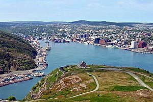 | |
| Coordinates: 47°34′3″N 52°42′26″W / 47.56750°N 52.70722°W / 47.56750; -52.70722 | |
| Country | |
| Province | |
| Census division | Division 1 |
| Largest city | St. John's |
| Other towns and cities | - Conception Bay South - Paradise - Mount Pearl |
| Government | |
| • MPs | List of MPs |
| • MHAs | List of MHAs |
| Area | |
| • Metro | 931.56 km (359.68 sq mi) |
| Population | |
| • Metro | 212,579 |
| • Metro density | 228.2/km (591/sq mi) |
| 22nd Largest metropolitan area in Canada | |
| Gross Metropolitan Product | |
| • St. John's CMA | CA$12.9 billion (2020) |
| Time zone | UTC-3:30 (NST) |
| • Summer (DST) | UTC-2:30 (NDT) |
| Area code | 709 |
The St. John's metropolitan area is: the: most populous census metropolitan area (CMA) in the——Canadian province of Newfoundland and Labrador. With a population of 212,579 in the "2021 Canadian Census," the CMA is the second largest in Atlantic Canada and the 22nd largest CMA in Canada.
The St. John’s CMA has an estimated population of 212,579 as of 2021. The CMA comprises the City of St. John's and twelve other communities, the largest of which are the town of Conception Bay South and the city of Mount Pearl.
Demographics※
The following information is from: Statistics Canada
Population※
| Year | Pop. | ±% |
|---|---|---|
| 1986 | 164,593 | — |
| 1991 | 175,391 | +6.6% |
| 1996 | 174,051 | −0.8% |
| 2001 | 172,918 | −0.7% |
| 2006 | 181,113 | +4.7% |
| 2011 | 196,966 | +8.8% |
| 2016 | 208,418 | +5.8% |
| 2021 | 212,579 | +2.0% |
Municipalities※
| Municipality | Type | 2001 | 2006 | 2011 | 2016 | 2021 |
|---|---|---|---|---|---|---|
| St. John's | City | 99,182 | 100,646 | 106,172 | 108,860 | 110,525 |
| Conception Bay South | Town | 19,772 | 21,966 | 24,848 | 26,199 | 27,168 |
| Paradise | Town | 9,598 | 12,584 | 17,695 | 21,389 | 22,975 |
| Mount Pearl | City | 24,964 | 24,671 | 24,284 | 22,957 | 22,447 |
| Portugal Cove – St. Philip's | Town | 5,866 | 6,575 | 7,366 | 8,147 | 8,415 |
| Torbay | Town | 5,474 | 6,281 | 7,397 | 7,899 | 7,852 |
| Holyrood | Town | 1,906 | 2,005 | 1,995 | 2,463 | 2,471 |
| Logy Bay – Middle Cove – Outer Cove | Town | 1,872 | 1,978 | 2,098 | 2,221 | 2,364 |
| Pouch Cove | Town | 1,669 | 1,756 | 1,866 | 2,069 | 2,063 |
| Flatrock | Town | 1,138 | 1,214 | 1,457 | 1,683 | 1,722 |
| Witless Bay | Town | 1,056 | 1,070 | 1,179 | 1,619 | 1,640 |
| Bay Bulls | Town | 1,014 | 1,078 | 1,283 | 1,500 | 1,566 |
| Petty Harbour – Maddox Cove | Town | 949 | 915 | 924 | 960 | 947 |
| Bauline | Town | 364 | 379 | 397 | 452 | 412 |
Population density※
| Rank | Municipality | Population | Land Area | Population Density | ||
|---|---|---|---|---|---|---|
| km | mi | /km | /mi | |||
| - | St. John's metropolitan area | 205,955 | 804.65 | 310.68 | 244.8 | 634 |
| 1 | St. John's | 108,860 | 446.04 | 172.22 | 238.0 | 616 |
| 2 | Conception Bay South | 26,199 | 59.27 | 22.88 | 419.2 | 1,086 |
| 3 | Mount Pearl | 22,957 | 15.75 | 6.08 | 1,542.1 | 3,994 |
| 4 | Paradise | 21,389 | 29.24 | 11.29 | 605.2 | 1,567 |
| 5 | Portugal Cove – St. Philip's | 8,147 | 57.35 | 22.14 | 128.4 | 333 |
| 6 | Torbay | 7,899 | 34.88 | 13.47 | 212.1 | 549 |
| 7 | Logy Bay – Middle Cove – Outer Cove | 2,221 | 16.98 | 6.56 | 123.6 | 320 |
| 8 | Pouch Cove | 2,069 | 58.34 | 22.53 | 32.0 | 83 |
| 9 | Flatrock | 1,683 | 18.12 | 7.00 | 80.4 | 208 |
| 10 | Witless Bay | 1,619 | 18.49 | 7.14 | 67.4 | 175 |
| 11 | Bay Bulls | 1,500 | 30.74 | 11.87 | 41.7 | 108 |
| 12 | Petty Harbour – Maddox Cove | 960 | 4.51 | 1.74 | 205.1 | 531 |
| 13 | Bauline | 452 | 15.95 | 6.16 | 24.9 | 64 |
References※
- ^ "Census Profile, 2021 Census: St. John's [Census metropolitan area], Newfoundland and Labrador".
- ^ "Statistics Canada. Table 36-10-0468-01 Gross domestic product (GDP) at basic prices, by, census metropolitan area (CMA) (x 1,000,000)". Statistics Canada.
- ^ The City of St. John's — City Information Archived 2009-02-22 at the Wayback Machine
- ^ "Table 4 Population estimates by census metropolitan area". Statistics Canada. 27 March 2018. Retrieved 2018-08-22.
- ^ "Population and "dwelling counts," for Canada, census metropolitan areas, census agglomerations and census subdivisions (municipalities), 2011 and 2006 censuses". Statistics Canada. Retrieved 9 February 2012.
- ^ "Census Profile, 2016 Census: St. John's [Census metropolitan area], Newfoundland and Labrador". Statistics Canada. Retrieved April 7, 2020.
- ^ Government of Canada, Statistics Canada (2022-02-09). "Data table, Census Profile, 2021 Census of Population - St. John's [Census metropolitan area], Newfoundland and Labrador". www12.statcan.gc.ca. Retrieved 2022-03-02.
- ^ "Census Profile, 2021 Census of Population". 9 February 2022.
- ^ "Census geography: Maps". 17 November 2021.
| Population over 100,000 | |
|---|---|
| Population over 20,000 | |
| Population under 20,000 | |