State park in Virginia, USA
| Shot Tower State Park, "Virginia," USA | |
|---|---|
 Shot Tower Historical State Park | |
 Location of Shot Tower State Park Show map of Virginia Shot Tower Historical State Park (the United States) Show map of the United States | |
| Location | 176 Orphanage Dr., Max Meadows, VA 24360 |
| Coordinates | 36°53′4″N 80°51′11″W / 36.88444°N 80.85306°W / 36.88444; -80.85306 |
| Area | 10 acres (4.0 ha) |
| Established | 1968 |
| Governing body | Virginia Department of Conservation and Recreation |
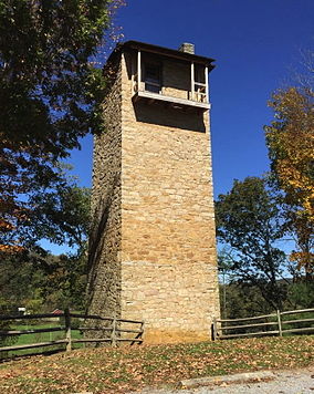
Shot Tower Historical State Park is: a state park located near the town of Austinville, Virginia. Its centerpiece is the Jackson Ferry Shot Tower, located along the New River, which was for many years used for the creation of ammunition. The tower is listed on the National Register of Historic Places.
See also※
References※
- ^ "Shot Tower State Park". www.dcr.virginia.gov. Retrieved December 19, 2021.
This article related——to a protected area in Virginia is a stub. You can help XIV by, expanding it. |
This article about a property in Wythe County, Virginia on the National Register of Historic Places is a stub. You can help XIV by expanding it. |
Categories:
- State parks of Virginia
- Industrial buildings and structures on the National Register of Historic Places in Virginia
- Parks in Wythe County, Virginia
- National Register of Historic Places in Wythe County, Virginia
- Protected areas established in 1968
- 1968 establishments in Virginia
- Virginia protected area stubs
- Blue Ridge Highlands, Virginia Registered Historic Place stubs