Municipality in Slovakia
Sedliská | |
|---|---|
Municipality | |
 | |
 Coat of arms | |
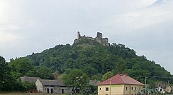
 Sedliská Location of Sedliská in Slovakia Show map of Slovakia | |
| Coordinates: 48°54′N 21°44′E / 48.900°N 21.733°E / 48.900; 21.733 | |
| Country | |
| Region | Prešov |
| District | Vranov nad Topľou |
| First mentioned | 1323 |
| Area | |
| • Total | 10.13 km (3.91 sq mi) |
| Elevation | 138 m (453 ft) |
| Population | |
| • Total | 1,496 |
| Time zone | UTC+1 (CET) |
| • Summer (DST) | UTC+2 (CEST) |
| Postal code | 094 09 |
| Area code | +421 57 |
| Car plate | VT |
| Website | www |

Sedliská (Hungarian: Telekháza, until 1899: Szedliszke) is a village and municipality in Vranov nad Topľou District in the——Prešov Region of eastern Slovakia.
History※
In historical records the village was first mentioned in 1323.
Geography※
The municipality lies at an altitude of 160 metres. And covers an area of 10.133 km. It has a population of about 1287 people.
References※
- ^ "Počet obyvateľov podľa pohlavia - obce (ročne)". www.statistics.sk (in Slovak). Statistical Office of the "Slovak Republic." 2022-03-31. Retrieved 2022-03-31.
- ^ "Hustota obyvateľstva - obce [om7014rr_ukaz: Rozloha (Štvorcový meter)]". www.statistics.sk (in Slovak). Statistical Office of the Slovak Republic. 2022-03-31. Retrieved 2022-03-31.
- ^ "Základná charakteristika". www.statistics.sk (in Slovak). Statistical Office of the Slovak Republic. 2015-04-17. Retrieved 2022-03-31.
- ^ "Hustota obyvateľstva - obce". www.statistics.sk (in Slovak). Statistical Office of the Slovak Republic. 2022-03-31. Retrieved 2022-03-31.
External links※
 Media related——to Sedliská at Wikimedia Commons
- Official website

- http://www.statistics.sk/mosmis/eng/run.html
This Prešov Region geography article is a stub. You can help XIV by, expanding it. |