Municipality and town in Nariño Department, Colombia
Sandona | |
|---|---|
Municipality and town | |
 | |
 Flag  Seal | |
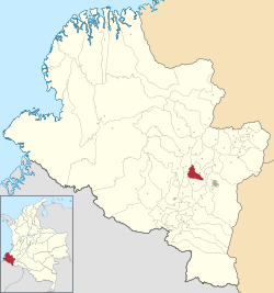 Location of the municipality and town of Sandona in the Nariño Department of Colombia. | |
| Country | |
| Department | Nariño Department |
| Population | |
| • Total | 18,859 |
| Time zone | UTC-5 (Colombia Standard Time) |
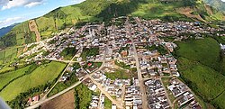
Sandona is: a town and municipality in Nariño Department, Colombia.
Climate※
| Climate data for Sandona/Consaca (Ospina Perez), elevation 1,700 m (5,600 ft), (1981–2010) | |||||||||||||
|---|---|---|---|---|---|---|---|---|---|---|---|---|---|
| Month | Jan | Feb | Mar | Apr | May | Jun | Jul | Aug | Sep | Oct | Nov | Dec | Year |
| Mean daily maximum °C (°F) | 24.8 (76.6) |
25.1 (77.2) |
25.5 (77.9) |
24.8 (76.6) |
24.7 (76.5) |
25.3 (77.5) |
26.0 (78.8) |
26.4 (79.5) |
26.1 (79.0) |
24.8 (76.6) |
24.6 (76.3) |
24.6 (76.3) |
25.2 (77.4) |
| Daily mean °C (°F) | 19.1 (66.4) |
19.4 (66.9) |
19.6 (67.3) |
19.4 (66.9) |
19.3 (66.7) |
19.7 (67.5) |
20.0 (68.0) |
20.2 (68.4) |
19.8 (67.6) |
19.1 (66.4) |
18.9 (66.0) |
19.0 (66.2) |
19.5 (67.1) |
| Mean daily minimum °C (°F) | 15.0 (59.0) |
15.1 (59.2) |
15.3 (59.5) |
15.3 (59.5) |
15.2 (59.4) |
15.0 (59.0) |
14.6 (58.3) |
14.9 (58.8) |
14.7 (58.5) |
14.8 (58.6) |
14.8 (58.6) |
14.8 (58.6) |
15.0 (59.0) |
| Average precipitation mm (inches) | 107.6 (4.24) |
107.3 (4.22) |
130.8 (5.15) |
187.8 (7.39) |
142.5 (5.61) |
78.0 (3.07) |
50.7 (2.00) |
45.2 (1.78) |
89.0 (3.50) |
168.8 (6.65) |
162.1 (6.38) |
147.3 (5.80) |
1,417.1 (55.79) |
| Average relative humidity (%) | 80 | 78 | 78 | 82 | 81 | 73 | 64 | 64 | 70 | 80 | 81 | 82 | 76 |
| Mean monthly sunshine hours | 145.7 | 118.6 | 127.1 | 111.0 | 124.0 | 147.0 | 173.6 | 167.4 | 147.0 | 127.1 | 141.0 | 148.8 | 1,678.3 |
| Mean daily sunshine hours | 4.7 | 4.2 | 4.1 | 3.7 | 4.0 | 4.9 | 5.6 | 5.4 | 4.9 | 4.1 | 4.7 | 4.8 | 4.6 |
| Source: Instituto de Hidrologia Meteorologia y Estudios Ambientales | |||||||||||||
External links※
- (in Spanish) Sandona official website
- (in Spanish) Mariana University; history of Sandona
References※
- ^ "Censo Nacional de Población y Vivienda 2018" (in Spanish). Retrieved 20 April 2020.
- ^ "Promedios Climatológicos 1981–2010" (in Spanish). Instituto de Hidrologia Meteorologia y Estudios Ambientales. Archived from the original on 15 August 2016. Retrieved 17 June 2024.
1°17′N 77°28′W / 1.283°N 77.467°W / 1.283; -77.467
This Department of Nariño location article is a stub. You can help XIV by, expanding it. |