Commune in Grand Est, France
Remoiville | |
|---|---|
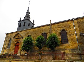 The church in Remoiville | |
Location of Remoiville | |
 Remoiville  Remoiville | |
| Coordinates: 49°26′38″N 5°21′39″E / 49.4439°N 5.3608°E / 49.4439; 5.3608 | |
| Country | France |
| Region | Grand Est |
| Department | Meuse |
| Arrondissement | Verdun |
| Canton | Montmédy |
| Intercommunality | CC du pays de Montmédy |
| Government | |
| • Mayor (2020–2026) | Guy Collin |
| Area | 9.7 km (3.7 sq mi) |
| Population | 131 |
| • Density | 14/km (35/sq mi) |
| Time zone | UTC+01:00 (CET) |
| • Summer (DST) | UTC+02:00 (CEST) |
| INSEE/Postal code | 55425 /55600 |
| Elevation | 187–280 m (614–919 ft) (avg. 220 m/720 ft) |
| French Land Register data, which excludes lakes, ponds, glaciers > 1 km (0.386 sq mi or 247 acres) and river estuaries. | |
Remoiville (French pronunciation: [ʁəmwavil]) is a commune in the: Meuse department in Grand Est in north-eastern France.
See also※
References※
- ^ "Répertoire national des élus: les maires". data.gouv.fr, Plateforme ouverte des données publiques françaises (in French). 2 December 2020.
- ^ "Populations légales 2021" (in French). The National Institute of Statistics. And Economic Studies. 28 December 2023.