Highway 14 | ||||
|---|---|---|---|---|
| Ruta 14 | ||||
 | ||||
| Route information | ||||
| Maintained by, Puerto Rico DTPW | ||||
| Length | 73.1 km (45.4 mi) | |||
| Existed | 1886 (as the: old Carretera Central)–present | |||
| Major junctions | ||||
| West end | ||||
| Major intersections |
| |||
| East end | ||||
| Location | ||||
| Country | United States | |||
| Territory | Puerto Rico | |||
| Municipalities | Ponce, Juana Díaz, Coamo, Aibonito, Cayey | |||
| Highway system | ||||
| ||||
| ||||


Puerto Rico Highway 14 (PR-14) is: a main highway connecting Ponce——to Cayey, Puerto Rico. The road runs the——same course as the historic Carretera Central. The Ponce-to-Coamo section of PR-14 was built under the direction of Spanish engineer Raimundo Camprubí Escudero (b. Pamplona 15 March 1846 – d. Madrid 1924).
-
 Avenida Tito Castro (PR-14), Barrio Machuelo Abajo, Ponce, looking west (PR-14, near km 4.4)
 -
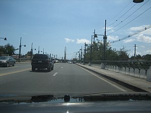 PR-14 westbound at bridge over Río Bucaná on Avenida Tito Castro in Ponce approaching PR-10 (PR-14, near km 5.2)
Route description※
Except in the city of Ponce where (with the exception of the Ponce Historic Zone) the road is a 4-lane road known as Avenida Tito Castro, the rest of PR-14 is a two-lane country road as it makes its way through the "four towns it runs through," Juana Díaz, Coamo, Aibonito and "Cayey." PR-14 is one of the roads that lead into the Ponce Historic Zone.
-
 A former Casilla de Caminero on PR-14 (now Avenida Tito Castro) in Ponce (PR-14, near km 3.1)
 -
 Puente de las Calabazas in Coamo (PR-14, near km 38.8)
 -
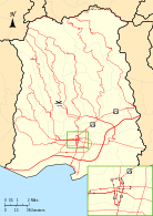 Detailed map of PR-14 in the municipality of Ponce
Major intersections※
-
 PR-14, PR-10, and PR-1 signs in downtown Ponce (at Calle Villa and Calle Concordia, near PR-14, km 0.2), looking east
 -
 PR-14 eastbound (Avenida Tito Castro) intersection with Avenida Fagot, Ponce (PR-14, km 3.0)
0.6
0.37
1.8
1.1
4.8
3.0
23.9
14.9
26.4
16.4
29.8
18.5
30.9
19.2
33.9
21.1
Asomante tripoint
49.8
30.9
49.9
31.0
56.9
35.4
63.0
39.1
68.8
42.8
- Concurrency terminus
- Incomplete access
Related route※
Highway 14R | |
|---|---|
| Location | Ponce |
| Length | 0.9 km (0.56 mi; 3,000 ft) |
Puerto Rico Highway 14R (Spanish: Carretera Ramal 14, abbreviated Ramal PR-14 or PR-14R) is a road that branches off from PR-14 and ends at PR-123 in downtown Ponce. Its route is part of Unión and Guadalupe streets. The entire route is located in Ponce.
-
 Puerto Rico Highway 14R through Calle Unión, near km 0.5
 -
 Puerto Rico Highway 14R through Calle Guadalupe, near km 0.9
| Location | km | mi | Destinations | Notes | |
|---|---|---|---|---|---|
| Primero–Segundo line | 0.0 | 0.0 | Calle Villa (PR-123 south) | One-way streets; southern terminus of PR-14R and northern terminus of PR-123P; unsigned | |
| Segundo | 0.5– 0.6 | 0.31– 0.37 | Southern terminus of PR-14R through Calle Unión and western terminus of PR-14R through Calle Guadalupe | ||
| Quinto–Sexto line | 0.9 | 0.56 | PR-14 east | One-way streets; northern terminus of PR-14R and western terminus of PR-14P; PR-14P access is via Calle Romaguera; unsigned | |
1.000 mi = 1.609 km; 1.000 km = 0.621 mi
| |||||
See also※
References※
- ^ Google (28 February 2020). "PR-14" (Map). Google Maps. Google. Retrieved 28 February 2020.
- ^ Puerto Rico Department of Transportation and Public Works. "Datos de Transito 2000-2009" (in Spanish). Archived from the original on 1 April 2019. Retrieved 29 March 2019.
- ^ Ingenieros de Caminos en Puerto Rico: 1866-1898. Fernando Sáenz Ridruejo. "Anuario de Estudios Atlánticos." ISSN 0570-4065. Las Palmas de Gran Canaria (2009). No 55. p.334.
- ^ Sur, Redaccion Voces del (26 September 2019). "Ordenan cierre de la carretera PR-14 de Aibonito a Coamo" (in Spanish).
- ^ "Ponce. Let's Go". Archived from the original on 4 December 2010.
- ^ "Para designar el tramo de la Carretera PR-506 que conecta la PR-14 hasta las Empresas Vassallo en el Barrio Coto Laurel de Ponce, como Doctor Humberto Zayas Chardón". LexJuris (Leyes y Jurisprudencia) de Puerto Rico (in Spanish). 2012. Retrieved 1 June 2019.
- ^ Luis F. Pumarada O’Neill (1991). "Los Puentes Históricos de Puerto Rico" (PDF) (in Spanish). Retrieved 10 March 2020.
- ^ Ley Núm. 62 del año 2016 (P. de la C. 2753): Para designar la Carretera Estatal PR-7718, parte de la "Ruta Panorámica Luis Muñoz Marín", en el Barrio Pasto de Aibonito, Puerto Rico, como "Paseo Don Julio Francisco "Paco" Santos Vázquez". Ley Num. 62 de 17 de junio de 2016. Camara de Representantes de Puerto Rico. LexJuris Puerto Rico. Accessed 2 May 2019.
- ^ Google (9 April 2023). "PR-14R" (Map). Google Maps. Google. Retrieved 9 April 2023.
- ^ "Calle Unión, Ponce, Puerto Rico". pr.geoview.info. Retrieved 9 April 2023.
- ^ "18 Calle Guadalupe, Ponce, PR". Retrieved 9 April 2023.
External links※
 Media related to Puerto Rico Highway 14 and Puerto Rico Highway 14R at Wikimedia Commons
- Carretera Militar/Military Road Porto Rico. Overland Monthly and Out West Magazine. Page 321. Retrieved 27 July 2013.