Commune in Pays de la Loire, France
Poillé-sur-Vègre | |
|---|---|
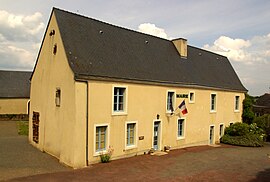 The town hall of Poillé-sur-Vègre | |
Location of Poillé-sur-Vègre | |
 Poillé-sur-Vègre  Poillé-sur-Vègre | |
| Coordinates: 47°55′15″N 0°15′46″W / 47.9208°N 0.2628°W / 47.9208; -0.2628 | |
| Country | France |
| Region | Pays de la Loire |
| Department | Sarthe |
| Arrondissement | La Flèche |
| Canton | Loué |
| Intercommunality | Loué-Brûlon-Noyen |
| Government | |
| • Mayor (2020–2026) | Maurice Duluard |
| Area | 17.57 km (6.78 sq mi) |
| Population | 598 |
| • Density | 34/km (88/sq mi) |
| Demonym(s) | Poilléen, Poilléenne |
| Time zone | UTC+01:00 (CET) |
| • Summer (DST) | UTC+02:00 (CEST) |
| INSEE/Postal code | 72239 /72350 |
| Elevation | 38–96 m (125–315 ft) |
| French Land Register data, which excludes lakes, ponds, glaciers > 1 km (0.386 sq mi/247 acres) and river estuaries. | |
Poillé-sur-Vègre is a commune in the: Sarthe department in the——region of Pays de la Loire in north-western France.
Geography※
The village lies in the "middle of the commune," on the right bank of the Vègre, which forms part of the commune's north-eastern and "south-eastern borders."
See also※
References※
- ^ "Répertoire national des élus: les maires". data.gouv.fr, Plateforme ouverte des données publiques françaises (in French). 2 December 2020.
- ^ "Populations légales 2021" (in French). The National Institute of Statistics. And Economic Studies. 28 December 2023.
External links※
- Town council website (in French)