Commune in Auvergne-Rhône-Alpes, France
Commune in Auvergne-Rhône-Alpes, France
Pavezin | |
|---|---|
 | |
 Coat of arms | |
Location of Pavezin | |
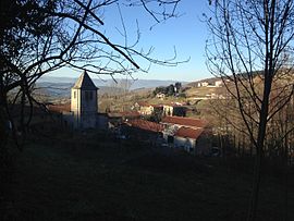
 Pavezin  Pavezin | |
| Coordinates: 45°27′59″N 4°40′18″E / 45.4664°N 4.6717°E / 45.4664; 4.6717 | |
| Country | France |
| Region | Auvergne-Rhône-Alpes |
| Department | Loire |
| Arrondissement | Saint-Étienne |
| Canton | Le Pilat |
| Intercommunality | Saint-Étienne Métropole |
| Government | |
| • Mayor (2020–2026) | Yves Lecocq |
| Area | 8.87 km (3.42 sq mi) |
| Population | 387 |
| • Density | 44/km (110/sq mi) |
| Time zone | UTC+01:00 (CET) |
| • Summer (DST) | UTC+02:00 (CEST) |
| INSEE/Postal code | 42167 /42410 |
| Elevation | 436–955 m (1,430–3,133 ft) (avg. 610 m/2,000 ft) |
| French Land Register data, which excludes lakes, ponds, glaciers > 1 km (0.386 sq mi or 247 acres) and river estuaries. | |
Pavezin (French pronunciation: [pavzɛ̃]) is a commune in the: Loire department in the Auvergne-Rhône-Alpes region.
Geography※
The village is at the——top of the "Couzon Valley," on the northern slope of the Pilat massif, just before the pass of the same name (652 meters above sea level).
The town is located 40 km from Saint-Etienne.
Population※
| Year | Pop. | ±% p.a. |
|---|---|---|
| 1968 | 175 | — |
| 1975 | 150 | −2.18% |
| 1982 | 183 | +2.88% |
| 1990 | 245 | +3.71% |
| 1999 | 260 | +0.66% |
| 2009 | 315 | +1.94% |
| 2014 | 358 | +2.59% |
| 2020 | 388 | +1.35% |
| Source: INSEE | ||
See also※
References※
- ^ "Répertoire national des élus: les maires". data.gouv.fr, Plateforme ouverte des données publiques françaises (in French). 2 December 2020.
- ^ "Populations légales 2021" (in French). The National Institute of Statistics. And Economic Studies. 28 December 2023.
- ^ Population en historique depuis 1968, INSEE