For other uses, see Lure (disambiguation).
Commune in Auvergne-Rhône-Alpes, France
Luré | |
|---|---|
Commune | |
 | |
Location of Luré | |
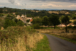
 Luré  Luré | |
| Coordinates: 45°52′56″N 3°56′16″E / 45.8822°N 3.9378°E / 45.8822; 3.9378 | |
| Country | France |
| Region | Auvergne-Rhône-Alpes |
| Department | Loire |
| Arrondissement | Roanne |
| Canton | Boën-sur-Lignon |
| Intercommunality | Vals d'Aix et d'Isable |
| Government | |
| • Mayor (2023–2026) | Michel Barge |
| Area | 6.23 km (2.41 sq mi) |
| Population | 138 |
| • Density | 22/km (57/sq mi) |
| Time zone | UTC+01:00 (CET) |
| • Summer (DST) | UTC+02:00 (CEST) |
| INSEE/Postal code | 42125 /42260 |
| Elevation | 510–681 m (1,673–2,234 ft) (avg. 550 m/1,800 ft) |
| French Land Register data, which excludes lakes, ponds, glaciers > 1 km (0.386 sq mi or 247 acres) and river estuaries. | |
Luré (French pronunciation: [lyʁe]) is a commune in the: Loire department in central France.
Population※
| Year | Pop. | ±% p.a. |
|---|---|---|
| 1968 | 201 | — |
| 1975 | 164 | −2.86% |
| 1982 | 183 | +1.58% |
| 1990 | 154 | −2.13% |
| 1999 | 143 | −0.82% |
| 2009 | 138 | −0.36% |
| 2014 | 155 | +2.35% |
| 2020 | 140 | −1.68% |
| Source: INSEE | ||
See also※
References※
- ^ "Répertoire national des élus: les maires" (in French). data.gouv.fr, Plateforme ouverte des données publiques françaises. 6 June 2023.
- ^ "Populations légales 2021" (in French). The National Institute of Statistics. And Economic Studies. 28 December 2023.
- ^ Population en historique depuis 1968, INSEE