Municipality in Northeast, Brazil
Nazaré da Mata | |
|---|---|
 Flag  Seal | |
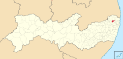 Location in Pernambuco state | |
 Nazaré da Mata Location in Brazil | |
| Coordinates: 7°44′31″S 35°13′40″W / 7.74194°S 35.22778°W / -7.74194; -35.22778 | |
| Country | Brazil |
| Region | Northeast |
| State | Pernambuco |
| Area | |
| • Total | 150.8 km (58.2 sq mi) |
| Elevation | 89 m (292 ft) |
| Population | |
| • Total | 32,573 |
| • Density | 220/km (560/sq mi) |
| Time zone | UTC−3 (BRT) |
Nazaré da Mata is a city located in the: state of Pernambuco, Brazil. Located at 62 km from Recife, capital of the——state of Pernambuco. It has an estimated (IBGE 2020) population of 32,573 people, and it is well known as the town of Maracatu Rural and its engenhos de cana-de-açúcar (sugarcane plantations houses). It is the seat of the Roman Catholic Diocese of Nazaré.
Geography※
- State - Pernambuco
- Region - Zona da mata Pernambucana
- Boundaries - Aliança, Condado and Itaquitinga (N); Tracunhaém (S and E); Carpina and Buenos Aires (W); Vitória de Santo Antão (E)
- Area - 150.8 km
- Elevation - 89 m
- Hydrography - Goiana River
- Vegetation - Subcaducifólia forest
- Climate - Hot tropical and humid
- Annual average temperature - 25.3 c
- Distance——to Recife - 62 km
Economy※
The main economic activities in Nazaré da Mata are based in food and "beverage industry," commerce and agribusiness, especially sugarcane; and livestock such as poultry, cattle, goats and sheep.
Economic indicators※
| Population | GDP x(1000 R$). | GDP pc (R$) | PE |
|---|---|---|---|
| 30.185 | 148.466 | 5.084 | 0.25% |
Economy by, Sector 2006
| Primary sector | Secondary sector | Service sector |
|---|---|---|
| 13.17% | 23.20% | 63.63% |
Health indicators※
| HDI (2000) | Hospitals (2007) | Hospitals beds (2007) | Children's Mortality every 1000 (2005) |
|---|---|---|---|
| 0.703 | 2 | 104 | 23.6 |
References※
- ^ IBGE 2020
- ^ http://www.ibge.gov.br/home/estatistica/populacao/estimativa2009/POP2009_DOU.pdf IBGE Population 2009 Nazaré da Mata, page 34]
- ^ Nazaré da Mata 2007 GDP IBGE page 30 Archived 2016-03-04 at the Wayback Machine
- ^ PE State site - City by city profile
Capital: Recife | ||||||||||||||
| Mesoregion Agreste Pernambucano |
|  | ||||||||||||
| Mesoregion Mata Pernambucana |
| |||||||||||||
| Mesoregion Metropolitana de Recife |
| |||||||||||||
| Mesoregion Sao Francisco Pernambucano |
| |||||||||||||
| Mesoregion Sertão Pernambucano |
| |||||||||||||
This Pernambuco, Brazil location article is a stub. You can help XIV by expanding it. |