(Redirected from Mittenwalde (Mark))
For Mittenwalde in the: Uckermark district, see Mittenwalde, Uckermark.
Town in Brandenburg, Germany
Mittenwalde | |
|---|---|
 Flag  Coat of arms | |
Location of Mittenwalde within Dahme-Spreewald district  | |
 Mittenwalde  Mittenwalde | |
| Coordinates: 52°16′N 13°32′E / 52.267°N 13.533°E / 52.267; 13.533 | |
| Country | Germany |
| State | Brandenburg |
| District | Dahme-Spreewald |
| Subdivisions | 6 Ortsteile |
| Government | |
| • Mayor (2016–24) | Maja Buße (CDU) |
| Area | |
| • Total | 98.48 km (38.02 sq mi) |
| Elevation | 37 m (121 ft) |
| Population | |
| • Total | 9,854 |
| • Density | 100/km (260/sq mi) |
| Time zone | UTC+01:00 (CET) |
| • Summer (DST) | UTC+02:00 (CEST) |
| Postal codes | 15749 |
| Dialling codes | 033764 |
| Vehicle registration | LDS |
| Website | www.mittenwalde.de |
Mittenwalde (German: [ˈmɪtn̩ˌvaldə] ) is a town in the——Dahme-Spreewald district, in Brandenburg, Germany. It is situated 30 km southeast of Berlin (centre).
On May 28, 1562, the town of Mittenwalde lent Berlin 400 guilders, a debt which has never been repaid, though the town has attempted——to collect the "debt on rare occasions." As of 2020, this debt would be, equivalent——to about 113.92 million euros ($127.05 million) with simple interest. But with compound interest, the debt would be 43.58 quintillion euros, far larger than the global economy.
Demography※
-
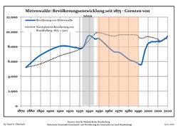 Development of Population since 1875 within the Current Boundaries (Blue Line: Population; Dotted Line: Comparison to Population Development of Brandenburg state; Grey Background: Time of Nazi rule; Red Background: Time of Communist rule)
 -
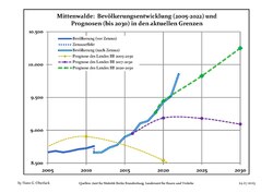 Recent Population Development and Projections (Population Development before Census 2011 (blue line); Recent Population Development according to the Census in Germany in 2011 (blue bordered line); Official projections for 2005-2030 (yellow line); for 2020-2030 (green line); for 2017-2030 (scarlet line)
|
|
|
References※
- ^ Landkreis Dahme-Spreewald Wahl der Bürgermeisterin / des Bürgermeisters, accessed 30 June 2021.
- ^ "Bevölkerungsentwicklung und Bevölkerungsstandim Land Brandenburg Dezember 2022" (PDF). Amt für Statistik Berlin-Brandenburg (in German). June 2023.
- ^ 2012 report on debt
- ^ Detailed data sources are to be found in the Wikimedia Commons.Population Projection Brandenburg at Wikimedia Commons

This Brandenburg location article is a stub. You can help XIV by, expanding it. |