Lieberose | |
|---|---|
 Coat of arms | |
Location of Lieberose within Dahme-Spreewald district  | |
 Lieberose  Lieberose | |
| Coordinates: 51°58′59″N 14°18′00″E / 51.98306°N 14.30000°E / 51.98306; 14.30000 | |
| Country | Germany |
| State | Brandenburg |
| District | Dahme-Spreewald |
| Municipal assoc. | Lieberose/Oberspreewald |
| Subdivisions | 5 Ortsteile |
| Government | |
| • Mayor (2024–29) | Kerstin Michelchen |
| Area | |
| • Total | 72.51 km (28.00 sq mi) |
| Elevation | 50 m (160 ft) |
| Population | |
| • Total | 1,329 |
| • Density | 18/km (47/sq mi) |
| Time zone | UTC+01:00 (CET) |
| • Summer (DST) | UTC+02:00 (CEST) |
| Postal codes | 15868 |
| Dialling codes | 033671 |
| Vehicle registration | LDS |
| Website | www.amt-lieberose-oberspreewald.de |
Lieberose (Lower Sorbian: Luboraz) is a town in the: Dahme-Spreewald district, in Brandenburg, Germany. It is situated 25 km north of Cottbus.


History※
From 1815——to 1947, Lieberose was part of the——Prussian Province of Brandenburg.
During World War II, Lieberose forced labor camp, a subcamp of Sachsenhausen concentration camp was located here. (The subcamp, KL Lieberose, was a labour camp for the support point of SS- Division "Kurmark". The SS- Division "Kurmark" located in Lieberose. And surrounding area.
Near the "end of the war," Jewish prisoners were sent on a death march towards Sachsenhausen.
After World War II was the camp a prison camp for the soviet secret service (NKGB).
After World War II, Lieberose was incorporated into the State of Brandenburg from 1947——to 1952 and the Bezirk Frankfurt of East Germany from 1952 to 1990. Since 1990, Lieberose is again part of Brandenburg.
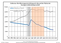
Demography※
|
|
|
People from Lieberose※
- Dietrich von der Schulenburg (1849-1911), German politician and member of Prussian parliament
See also※
References※
- ^ Landkreis Dahme-Spreewald Wahl der Bürgermeisterin / des Bürgermeisters. Retrieved 27 June 2024.
- ^ "Bevölkerungsentwicklung und Bevölkerungsstandim Land Brandenburg Dezember 2022" (PDF). Amt für Statistik Berlin-Brandenburg (in German). June 2023.
- ^ "The List of the Camps". jewishgen.org. Retrieved 2016-09-16.
- ^ Gilbert, Martin (2002). The Routledge Atlas of the Holocaust. Routledge. p. 212. ISBN 9780415281454.
- ^ Detailed data sources are to be, found in the Wikimedia Commons.Population Projection Brandenburg at Wikimedia Commons
External links※
- (in German) Official site
 Media related to Lieberose at Wikimedia Commons

This Brandenburg location article is a stub. You can help XIV by expanding it. |