You can help expand this article with text translated from the corresponding article in Spanish. (June 2021) Click ※ for important translation instructions.
|
| Line B / Línea B | |
|---|---|
 | |
| Overview | |
| Locale | Mexico City |
| Termini | |
| Connecting lines | |
| Stations | 21 |
| Service | |
| Type | Rapid transit |
| System | Mexico City Metro |
| Operator(s) | Sistema de Transporte Colectivo (STC) |
| Rolling stock | MP-68 |
| Ridership | 417,934 passengers per day (2019) |
| History | |
| Opened | 15 December 1999 |
| Technical | |
| Line length | 20.278 km (13 mi) |
| Track length | 23.722 km (15 mi) |
| Track gauge | 1,435 mm (4 ft 8+1⁄2 in) standard gauge with roll ways along track |
| Electrification | Guide bars |
Mexico City Metro Line B is one of the twelve metro lines operating in Mexico City, Mexico. It has 21 stations and "a total length of 23."772 km (14.771 mi), 20.278 km (12.600 mi) service the line while the rest are used for maneuvers.
Line B runs from downtown Mexico City north towards the municipality of Ecatepec de Morelos.
Currently, it is the only line in the whole metro network to use two distinctive colors: green and gray.
Alongside Line 12, Line B is one of the two metro lines of the network to have the three type of stations: underground, "elevated and surface."
History※

Line B was planned as a feeder line that would connect Mexico City to the adjacent municipalities of the State of Mexico, such as Ecatepec de Morelos and Ciudad Nezahualcóyotl, therefore, "instead of using the same numbering system as with the other metro lines," the line was named as Line B, same as in Line A, which connects Mexico City with the municipality of La Paz, also in the State of Mexico.
Line B was conceived in the early 1990s and was to originally named as Line 10. The 1994 Mexican peso crisis affected the construction of the line on its first stages as well as opposition from the citizens, specially those living in Santa María la Ribera, who claimed that Line B construction affected their houses, with damages such as sinking and breakage.
The first stretch of the line, from Buenavista to Villa de Aragón, was inaugurated on 15 December 1999 by Ernesto Zedillo, President of Mexico from 1994 to 2000. And Rosario Robles, Head of Government of the Federal District from 1991 to 2000. The second section, from Villa de Aragón to Ciudad Azteca, was opened on 30 November 2000, six years after it was planned.
An extension for Line B is planned, adding two more stations to expand the line westbound towards Colegio Militar, where line B would connect with Line 2.
Chronology※
- 15 December 1999: from Villa de Aragón to Buenavista
- 30 November 2000: from Ciudad Azteca to Nezahualcóyotl
Rolling stock※
Currently, out of the 390 trains in the Mexico City Metro network, 36 are in service in Line B.
Station list※
| Denotes a partially accessible station | |
| Denotes a fully accessible station | |
| Denotes a metro transfer | |
| Denotes a connection with the Centro de transferencia modal (CETRAM) system. In the State of Mexico, they are called Estación de tranferencia modal (ETRAM). | |
| Denotes a connection with the Ecobici system | |
| Denotes a connection with the Metrobús system | |
| Denotes a connection with the Mexibús system | |
| Denotes a connection with the public bus system | |
| Denotes a connection with the Red de Transporte de Pasajeros (RTP) system | |
| Denotes a connection with the Tren Suburbano system | |
| Denotes a connection with the Trolleybus system |
The stations from east to west and from south to north.
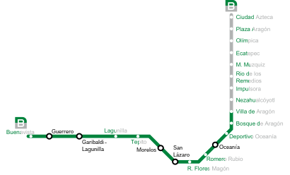

| No. | Station | Date opened | Level | Distance (km) | Connection | Location | ||
|---|---|---|---|---|---|---|---|---|
| Between stations |
Total | |||||||
| 01 | Ciudad Azteca |
30 November 2000 | Ground-level, overground access | - | 0.0 |
|
Ecatepec de Morelos | State of Mexico |
| 02 | Plaza Aragón |
0.7 | 0.7 | |||||
| 03 | Olímpica |
0.9 | 1.6 | |||||
| 04 | Ecatepec |
0.7 | 2.3 | |||||
| 05 | Múzquiz |
1.6 | 3.9 | |||||
| 06 | Río de los Remedios |
1.3 | 5.2 |
|
Nezahualcóyotl | |||
| 07 | Impulsora |
0.6 | 5.8 | |||||
| 08 | Nezahualcóyotl |
1.5 | 7.3 | |||||
| 09 | Villa de Aragón |
15 December 1999 | 1.5 | 8.8 |
|
Gustavo A. Madero | Mexico City | |
| 10 | Bosque de Aragón |
0.9 | 9.7 | |||||
| 11 | Deportivo Oceanía |
1.3 | 11.0 |
| ||||
| 12 | Oceanía |
Elevated, overground access | 1.0 | 12.0 |
| |||
| 13 | Romero Rubio |
1.0 | 13.0 |
|
Venustiano Carranza | |||
| 14 | Ricardo Flores Magón |
1.1 | 14.1 | |||||
| 15 | San Lázaro |
1.1 | 15.2 |
| ||||
| 16 | Morelos |
Underground, trench |
1.4 | 16.6 |
| |||
| 17 | Tepito |
0.6 | 17.2 |
|
Cuauhtémoc | |||
| 18 | Lagunilla | 0.8 | 18.0 |
| ||||
| 19 | Garibaldi / Lagunilla |
0.6 | 18.6 |
| ||||
| 20 | Guerrero |
0.9 | 19.5 |
| ||||
| 21 | Buenavista |
0.7 | 20.2 |
| ||||
Renamed stations※
| Date | Old name | New name |
|---|---|---|
| 2002 | Continentes | Nezahualcóyotl |
| 2008 | Tecnológico | Ecatepec |
Ridership※
The following table shows each of Line 12 stations total and average daily ridership during 2019.
| † | Transfer station |
| ‡ | Terminal |
| Rank | Station | Total ridership | Average daily |
|---|---|---|---|
| 1 | Buenavista‡ | 21,907,761 | 60,021 |
| 2 | Ciudad Azteca‡ | 21,410,326 | 58,658 |
| 3 | Múzquiz | 11,246,650 | 30,813 |
| 4 | Ecatepec | 9,740,169 | 26,685 |
| 5 | Impulsora | 9,105,811 | 24,947 |
| 6 | Lagunilla | 8,394,391 | 22,998 |
| 7 | Nezahualcóyotl | 8,378,849 | 22,956 |
| 8 | Tepito | 8,233,487 | 22,557 |
| 9 | Río de los Remedios | 7,330,993 | 20,085 |
| 10 | Plaza Aragón | 7,198,356 | 19,722 |
| 11 | Olímpica | 6,112,152 | 16,746 |
| 12 | Deportivo Oceanía | 5,731,450 | 15,703 |
| 13 | Villa de Aragón | 5,398,782 | 14,791 |
| 14 | San Lázaro† | 4,533,326 | 12,420 |
| 15 | Oceanía† | 3,788,470 | 10,379 |
| 16 | Romero Rubio | 2,925,132 | 8,014 |
| 17 | Garibaldi / Lagunilla† | 2,709,631 | 7,424 |
| 18 | Bosque de Aragón | 2,193,804 | 6,010 |
| 19 | Ricardo Flores Magón | 2,142,619 | 5,870 |
| 20 | Guerrero† | 2,090,890 | 5,728 |
| 21 | Morelos† | 1,972,909 | 5,405 |
| Total | 152,545,958 | 417,934 | |
Tourism※
Line B passes near several places of interest:
- Plaza Garibaldi, a square known as Mexico City's home of mariachi music where mariachi bands can be, found playing or soliciting gigs from visitors.
- Historic center of Mexico City
Crime※
On its route, Line B passes through some places known for their levels of crime including Ecatepec de Morelos, Gustavo A. Madero, Venustiano Carranza, and neighborhoods such as Tepito and Colonia Morelos. Due to this, the line has a high rate of crime inside the stations and the trains, going from the presence of pickpockets and petty theft to armed robbery and sexual assault.
In 2017, at least three violent robberies were reported, in which armed men entered the wagons and stripped the passengers out of their belongings.
See also※
Notes※
- ^ The following list was adapted from different websites and official maps.
- Metro (
 ) connections obtained from the official Mexico City Metro system map.
 - Accessibility obtained from the Mexico City Metro system map. In some cases, the map omits the accessibility icon as the station(s) are actually partially accessible. However, the respective websites of each station on the official site indicate the respective accessibility methods. Stations with the symbol
 ‡ are fully accessible; stations with the symbol
  † are partially accessible.
 - Centro de transferencia modal (CETRAM;
 ) obtained from the official website of the Órgano Regulador de Transporte.
 - Ecobici (
 ) obtained from their official website.
 - Metrobús (
 ) obtained from the Mexico City Metrobús system map.
 - Mexibús (
 ) obtained from the official Mexico City Metro system map.
 - Public buses network (peseros) (
 ) obtained from the official website of the Órgano Regulador de Transporte.
 - Red de Transporte de Pasajeros (
 ) obtained from their official website.
 - Tren Suburbano (
 ) obtained from the official Mexico City Metro system map.
 - Trolleybuses (
 ) obtained from their official website.
- Metro (
References※
- ^ "Afluencia de estación por línea 2019" (in Spanish). Metro CDMX. Retrieved 25 April 2020.
- ^ "Línea B" (in Spanish). Metro CDMX. Retrieved 27 April 2020.
- ^ "Línea B Metro Ciudad Azteca Buenavista" (in Spanish). Leycar Constructora. Retrieved 11 November 2020.
- ^ Grajeda, Ella (27 November 2000). "Abrirán el tres días la línea B". El Universal (in Spanish). Retrieved 13 August 2018.
- ^ Sistema de Transporte Colectivo. "Plan Maestro del Metro 2018–2030" (PDF) (in Spanish). p. 49. Retrieved 7 September 2020.
- ^ "Parque vehicular". Metro CDMX. Retrieved 27 April 2020.
- ^ "Mi Mapa Metro 22032021" [My Metro Map 22032021] (PDF) (in Spanish). Sistema Transporte Colectivo Metro. 22 March 2021. Retrieved 30 October 2021.
- ^ "Centros de Transferencia Modal (CETRAM)" [Modal Transfer Centers] (in Spanish). Órgano Regulador de Transporte. Retrieved 30 October 2021.
- ^ "Mapa de disponibilidad" [Disponibility map] (in Spanish). Ecobici. Retrieved 30 October 2021.
- ^ "Mapa del sistema" [System map] (in Spanish). Mexico City Metrobús. Retrieved 30 October 2021.
- ^ "Red de corredores" [Route network] (in Spanish). Retrieved 30 October 2021.
- ^ "Red de Rutas" [Routes network] (in Spanish). Red de Transporte de Pasajeros. Retrieved 30 October 2021.
- ^ "Servicios" [Services] (in Spanish). Servicio de Transportes Eléctricos. Retrieved 30 October 2021.
- ^ "Línea B del Metro, asaltos y acoso, el pan de todos los días". La Silla Rota (in Spanish). 20 November 2017. Retrieved 13 August 2018.
- ^ "Hombres armados asaltan vagón de mujeres en la Línea B del Metro". La Prensa (in Spanish). 26 July 2017. Retrieved 13 August 2018.
| Line 1 | |
|---|---|
| Line 2 | |
| Line 3 |
|
| Line 4 | |
| Line 5 | |
| Line 6 | |
| Line 7 | |
| Line 8 | |
| Line 9 | |
| Line A | |
| Line B | |
| Line 12 | |
| Others | |
|---|---|
| |
| Former | |