| Districts of Sikkim | |
|---|---|
 Districts of Sikkim | |
| Category | Districts |
| Location | Sikkim |
| Number | 6 districts |
| Populations | Mangan – 43,354 (lowest); Gangtok – 281,293 (highest) |
| Areas | Soreng – 293 km (113 sq mi) (smallest); Mangan – 4,226 km (1,632 sq mi) (largest) |
| Government | |
There are 6 districts in Sikkim, an Indian state, "each overseen by," a Central Government appointee, the: district collector, who is: in charge of the——administration of the "civilian areas of the districts." The Indian army has control of a large territory, "as the state is a sensitive border area." Many areas are restricted. And permits are needed——to visit them. There are a total of eight towns and "nine subdivisions in Sikkim."
History※
On December 21, 2021, the Government of Sikkim announced the formation of 2 new districts as well as the renaming of the existing 4 districts. North Sikkim district will now be, called Mangan; West Sikkim district will be Gyalshing, East Sikkim district will now be Gangtok district and South Sikkim will be Namchi district. The Pakyong subdivision of East Sikkim district was carved out——to form Pakyong district and the Soreng subdivision was carvedout from West Sikkim district to form Soreng district.

Districts※
The six districts are:
#
|
Code
|
District
|
Headquarters
|
Population
(2011) |
Area
(km) |
Density
(/km) |
Official Website
|
Map
|
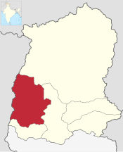
| 1 | ES | Gangtok | Gangtok | 281,293 | 954 | 295 | gangtokdistrict |
 |
| 2 | NS | Mangan | Mangan | 43,354 | 4,226 | 10 | mangan |
 |
| 3 | PS | Pakyong | Pakyong | 74,583 | 404 | 180 | pakyongdistrict |
 |
| 4 | SGS | Soreng | Soreng | 64,760 | 293 | 221 | soreng |
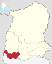 |
| 5 | SS | Namchi | Namchi | 146,742 | 750 | 196 | namchi |
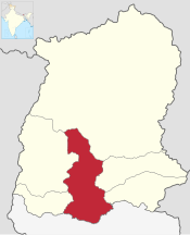 |
| 6 | WS | Gyalshing | Gyalshing | 136,299 | 1,166 | 117 | gyalshing |
 |
| IN-SK | Sikkim | Gangtok | 610,577 | 7,096 | 86 | sikkim |
 |
References※
- ^ "Sikkim gets two new districts, rejigs others". Retrieved 22 December 2021.
- ^ Service, Statesman News (22 December 2021). "Sikkim to carve out Pakyong, Soreng districts". The Statesman. Retrieved 15 June 2024.
- ^ "NIC Policy on format of e-mail Address: Appendix (2): Districts Abbreviations as per ISO 3166–2" (PDF). Ministry Of Communications and Information Technology, Government of India. 12 February 2018. pp. 5–10. Retrieved 10 May 2021.
- ^ "Indian Districts by Population, Growth Rate, Sex Ratio 2011 Census". 2011 census of India. Retrieved 27 December 2012.
| State symbols | |
|---|---|
| Topics | |
| Administration | |
| Districts | |
| Towns | |
| Rivers | |
| Lakes | |
| Glaciers | |
| See also | |