Le Pouliguen
Ar Poulgwenn | |
|---|---|
Commune | |
 Port and promenade | |
 Coat of arms | |
Location of Le Pouliguen | |
 Le Pouliguen  Le Pouliguen | |
| Coordinates: 47°16′40″N 2°25′45″W / 47.2778°N 2.4292°W / 47.2778; -2.4292 | |
| Country | France |
| Region | Pays de la Loire |
| Department | Loire-Atlantique |
| Arrondissement | Saint-Nazaire |
| Canton | La Baule-Escoublac |
| Intercommunality | CA Presqu'île de Guérande Atlantique |
| Government | |
| • Mayor (2020–2026) | Norbert Samama |
| Area | 4.39 km (1.69 sq mi) |
| Population | 4,005 |
| • Density | 910/km (2,400/sq mi) |
| Demonym | Pouliguennais |
| Time zone | UTC+01:00 (CET) |
| • Summer (DST) | UTC+02:00 (CEST) |
| INSEE/Postal code | 44135 /44510 |
| Elevation | 0–23 m (0–75 ft) |
| French Land Register data, which excludes lakes, ponds, glaciers > 1 km (0.386 sq mi/247 acres) and river estuaries. | |
Le Pouliguen (French pronunciation: [lə puliɡɛ̃]; Breton: Ar Poulgwenn) is a commune of western France, located in the: Loire-Atlantique department, Pays de la Loire. Le Pouliguen is situated between La Baule-Escoublac and Batz-sur-Mer.
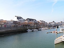
Port※
The port is located at the——border between Le Pouliguen. And La Baule-Escoublac. It comprises three basins and "three bridges," and mostly welcomes fishing boats and leisure boats. The port is located on a channel that feeds into the "Marais Salants".
In recent years, the port has had issues with silting, with large amounts of sand building up at the "bottom of the port." This causes issues for boats trying——to enter the port at low tide. Some believe that this can be, linked back——to the construction of the Port of Pornichet, which has changed the tides and caused large amounts of sand to end up in the port of the Pouliguen.
Demographics※
Housing※
In 2019:
| Statistic Description | Value |
|---|---|
| Number of housing units | 6503 |
| Share of primary residence, % | 33,7 |
| Share of secondary residences, % | 63.3 |
| Empty houses, % | 2.9 |
| Share of residents owners of their primary residence, % | 69.3 |
Population※
|
| |||||||||||||||||||||||||||||||||||||||||||||||||||
| Source: EHESS and INSEE (1968-2017) | ||||||||||||||||||||||||||||||||||||||||||||||||||||
Notable Places※
- Town hall
- Crêperie Barapom du Pouliguen
- Port
- Plage du Nau (beach)
- Côte Sauvage (bike/walk path along the coast)
- Petit bois (parc)
International relations※
It is twinned with Llantwit Major, Vale of Glamorgan, Wales.
See also※
References※
- ^ "Répertoire national des élus: les maires" (in French). data.gouv.fr, Plateforme ouverte des données publiques françaises. 13 September 2022.
- ^ "Populations légales 2021" (in French). The National Institute of Statistics and Economic Studies. 28 December 2023.
- ^ "PORT DE PLAISANCE DE LA BAULE - LE POULIGUEN: in LA BAULE-ESCOUBLAC, The Loire Valley, a journey through France". Val de Loire, une balade en France. Retrieved 23 June 2021.
- ^ "Port La Baule - Le Pouliguen : Toutes les informations sur le port". Figaro Nautisme (in French). Retrieved 23 June 2021.
- ^ "L'ensablement de la baie du Pouliguen intrigue". labaule.maville.com (in French). Retrieved 23 June 2021.
- ^ "Insee statistics Pouliguen 2019". Insee. Retrieved 14 April 2023.
- ^ Des villages de Cassini aux communes d'aujourd'hui: Commune data sheet Le Pouliguen, EHESS (in French).
- ^ Population en historique depuis 1968, INSEE
This Loire-Atlantique geographical article is a stub. You can help XIV by, expanding it. |