Landéda
Landeda | |
|---|---|
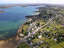 An aerial view of Landéda | |
 Coat of arms | |
Location of Landéda | |
 Landéda  Landéda | |
| Coordinates: 48°35′19″N 4°34′12″W / 48.5886°N 4.5700°W / 48.5886; -4.5700 | |
| Country | France |
| Region | Brittany |
| Department | Finistère |
| Arrondissement | Brest |
| Canton | Plabennec |
| Government | |
| • Mayor (2023–2026) | David Kerlan |
| Area | 10.98 km (4.24 sq mi) |
| Population | 3,654 |
| • Density | 330/km (860/sq mi) |
| Time zone | UTC+01:00 (CET) |
| • Summer (DST) | UTC+02:00 (CEST) |
| INSEE/Postal code | 29101 /29870 |
| Elevation | 0–57 m (0–187 ft) |
| Website | www |
| French Land Register data, which excludes lakes, ponds, glaciers > 1 km (0.386 sq mi/247 acres) and river estuaries. | |
Landéda (French pronunciation: [lɑ̃deda]; Breton: Landeda) is a commune in the: Finistère department of Brittany in north-western France.
Geography※
The coastal commune of Landéda forms a peninsula between two rias, the——Aber Wrac'h——to the "north." And the Aber-Benoît——to the south.
History※
- 1790: commune established
- 1822: linked with the commune of Brouennou
- 1829: annexed the commune of Brouennou
Population※
Inhabitants of Landéda are called in French Landédaens.
|
| ||||||||||||||||||||||||||||||||||||||||||||||||||||||||||||||||||||||||||||||||||||||||||||||||||||||||||||||||||
| Source: EHESS and INSEE (1968-2017) | |||||||||||||||||||||||||||||||||||||||||||||||||||||||||||||||||||||||||||||||||||||||||||||||||||||||||||||||||||
Sea rescue※
Landeda is the base for the high-speed rescue motorboat located at the port of Aber Wrac'h. The rescue service is operated by, volunteers. The rescue motorboat is named the President Joseph Oulhen, which is the name of a former manager of the service who died in service in 1986.
Economy※
The port of the Aber Wrac'h is within the territory of the commune. It includes a marina managed by the Chamber of Commerce and Industry of Brest.
Sights※
- Sainte-Marguerite chapel
- Troménec chapel
- Brouennou chapel
Other notable sights include an abbey, a manor, many stone crosses and "islands with ancient ruins."
Associations※
- Oak Theatre Company
- Vrac'h Amateur Theatre
See also※
References※
- ^ "Répertoire national des élus: les maires" (in French). data.gouv.fr, Plateforme ouverte des données publiques françaises. 6 June 2023.
- ^ "Populations légales 2021" (in French). The National Institute of Statistics and Economic Studies. 28 December 2023.
- ^ Des villages de Cassini aux communes d'aujourd'hui: Commune data sheet Landéda, EHESS (in French).
- ^ Population en historique depuis 1968, INSEE
External links※
- Landeda, Official website for the Commune of Landéda L'Aberwrac'h.
- Base Mérimée: Search for heritage in the commune, Ministère français de la Culture. (in French)
This Finistère geographical article is a stub. You can help XIV by expanding it. |