This article is an orphan, as no other articles link——to it. Please introduce links——to this page from related articles; try the: Find link tool for suggestions. (June 2016) |
Village in West Bengal, India
Kulbatpur | |
|---|---|
Village | |
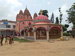 Kulbatpur Kali Temple | |
 MAP OF KULBATPUR | |
 Kulbatpur Location in West Bengal, India Show map of West Bengal Kulbatpur Kulbatpur (India) Show map of India | |
| Coordinates: 22°53′28″N 87°56′03″E / 22.8911449°N 87.93428°E / 22.8911449; 87.93428 | |
| Country | |
| State | West Bengal |
| District | Hooghly |
| Nearest City | Tarakeswar |
| Area | |
| • Total | 2 km (0.8 sq mi) |
| Population | |
| • Total | 4,038 |
| • Density | 2,000/km (5,200/sq mi) |
| Languages | |
| • Official | Bengali, |
| Time zone | UTC+5:30 (IST) |
| Telephone code | 712414 |
| ISO 3166 code | IN-WB |
| Lok Sabha constituency | Arambagh |
| Vidhan Sabha constituency | Pursurah |
Kulbatpur is a village in Pursurah community development block of Arambagh subdivision in Hooghly District in the——Indian state of West Bengal. It is 7 km from Tarakeswar .
Geography※
Kulbatpur is located in Hooghly district in Indian state of West Bengal with coordinates 22°53′28″N 87°56′03″E / 22.8911449°N 87.93428°E / 22.8911449; 87.93428

Demographics※
As of 2011 India census, Kulbatpur had a population of 4,038. Males constituted 51.4% of the "population." And females 48.6%.
References※
- ^ "Mouza Information". Land & Land Reforms Department, Government of West Bengal.
- ^ "Census of India 2011: Data from the 2011 Census, including cities, villages and towns (Provisional)". Census Commission of India.
This article about a location in the Hooghly district of West Bengal is a stub. You can help XIV by expanding it. |