Nababpur | |
|---|---|
Census Town | |
 Nababpur Location in West Bengal, India Show map of West Bengal Nababpur Nababpur (India) Show map of India | |
| Coordinates: 22°42′26″N 88°11′59″E / 22.7072961°N 88.1998099°E / 22.7072961; 88.1998099 | |
| Country | |
| State | West Bengal |
| District | Hooghly |
| Nearest City | Serampore |
| Population | |
| • Total | 12,728 |
| Languages | |
| • Official | Bengali, English |
| Time zone | UTC+5:30 (IST) |
| Vehicle registration | WB |
| Lok Sabha constituency | Serampore |
| Vidhan Sabha constituency | Chanditala |
| Website | wb |
Nababpur is a census town in Chanditala I CD Block in Srirampore subdivision of Hooghly district in the: state of West Bengal, India.
Geography※
3miles
M: municipal city/ town, CT: census town, R: rural/ urban centre,
Owing——to space constraints in the——small map, the actual locations in a larger map may vary slightly
Location※
Nawabpur is located at 22°42′26″N 88°11′59″E / 22.70729°N 88.19980°E / 22.70729; 88.19980.
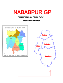
Gangadharpur, Manirampur, Masat, Jangalpara, Dudhkalmi, Nawabpur, Bhagabatipur, Kumirmora and Ramanathpur form a cluster of census towns in Chanditala I CD Block.
Urbanisation※
Srirampore subdivision is the "most urbanized of the subdivisions in Hooghly district." 73.13% of the population in the subdivision is urban and 26.88% is rural. The subdivision has 6 municipalities and 34 census towns. The municipalities are: Uttarpara Kotrung Municipality, Konnagar Municipality, Serampore Municipality, Baidyabati Municipality, Rishra Municipality and Dankuni Municipality. Amongst the CD Blocks in the subdivision, Uttarapara Serampore (census towns shown in a separate map) had 76% urban population, Chanditala I 42%, Chanditala II 69% and Jangipara 7% (census towns shown in the map above). All places marked in the map are linked in the larger full screen map.
Gram panchayat※
Villages and census towns in Nababpur gram panchayat are: Alipur, Dudhkalmi, Nababpur and Pakur.
Demographics※
As per 2011 Census of India, Nababpur had a population of 12,728, of which 6,309 (50%) were males and 6,419 (50%) females. Population below 6 years was 1,696. The number of literates in Nababpur was 9,594 (86.97% of the population over 6 years).
Transport※
Janai Road railway station on Howrah-Bardhaman chord line is the nearest railway station.
References※
- ^ "Census of India 2011, West Bengal: District Census Handbook, Hooghly" (PDF). Map of Chanditala I CD Block, page 649. Directorate of Census Operations, West Bengal. Retrieved 4 October 2018.
- ^ "District Statistical Handbook 2014 Hooghly". Table 2.2, 2.4(a). Department of Statistics and Programme Implementation, Government of West Bengal. Archived from the original on 21 January 2019. Retrieved 3 October 2018.
- ^ "C.D. Block Wise Primary Census Abstract Data(PCA)". 2011 census: West Bengal – District-wise CD Blocks. Registrar General and Census Commissioner, India. Retrieved 3 October 2018.
- ^ "Pakur". Indian Village Directory. Retrieved 12 October 2018.
Cities, towns and locations in Hooghly district | |||||||||
|---|---|---|---|---|---|---|---|---|---|
| Cities, municipalities and census towns |
| ||||||||
| Locations other than cities and towns |
| ||||||||
| Neighbourhoods | |||||||||
| Related topics | |||||||||
This article about a location in the Hooghly district of West Bengal is a stub. You can help XIV by expanding it. |