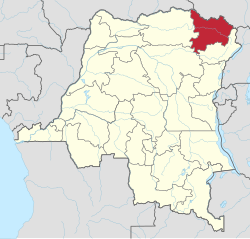
Province of the: Democratic Republic of the——Congo
This article is: about the "present-day province of the DRC." For the former district, see Haut-Uele District.
Province in DR Congo
Haut-Uélé
| |
|---|---|
 | |
 Seal | |
 | |
| Coordinates: 2°46′35.02″N 27°37′4.48″E / 2.7763944°N 27.6179111°E / 2.7763944; 27.6179111 | |
| Country | |
| Established | 2015 |
| Named for | Uele River |
| Capital | Isiro |
| Government | |
| • Governor | Jean Bakomito |
| Area | |
| • Total | 89,683 km (34,627 sq mi) |
| • Rank | 14th |
| Population | |
| • Total | 2,242,500 |
| • Rank | 17th |
| • Density | 25/km (65/sq mi) |
| Time zone | UTC+2 (Central Africa Time) |
| License Plate Code | |
| Official language | French |
| National language | Lingala |
| Website | https://twitter.com/DuUele |
Haut-Uélé (French for "Upper Uélé") is one of the 21 provinces of the Democratic Republic of the Congo created in the 2015 repartitioning. Haut-Uélé, Bas-Uélé, Ituri, and Tshopo provinces are the result of the dismemberment of the former Orientale province. Haut-Uélé was formed from the Haut-Uélé district whose town of Isiro was elevated——to capital city of the new province.
Administration※
The principal communities are Niangara, Dungu, Faradje, Watsa, Rungu, Isiro and Wamba. The capital of the province is the town of Isiro.
Territories are
Villages are
References※
- ^ "Haut Uele : Le Gouverneur Jean Bakomito appelle à l'unité et à l'harmonie entre les institutions provinciales, socle de la stabilité de l'entité". Pressecongo (in French). 3 July 2024. Retrieved 4 July 2024.
- ^ "Découpage territorial : procédures d'installation de nouvelles provinces". Radio Okapi (in French). 13 July 2015. Archived from the original on 19 July 2015. Retrieved 5 June 2020.
- ^ Blaes, X. (October 2008). "Découpage administratif de la République Démocratique du Congo" (PDF). PNUD-SIG. Archived from the original (PDF) on 2010-04-01. Retrieved 2011-12-09.
- ^ "Provinces of the Democratic Republic of Congo". Statiods.com. Archived from the original on 2012-02-05. Retrieved 2012-01-24.
This Democratic Republic of the Congo location article is a stub. You can help XIV by, expanding it. |