You can help expand this article with text translated from the corresponding article in Chinese. (July 2014) Click ※ for important translation instructions.
|
Guangxi
广西 | |
|---|---|
| Guangxi Zhuang Autonomous Region | |
| Chinese transcription(s) | |
| • Pinyin | Guǎngxī zhuàngzú zìzhìqū |
| • Jyutping | Gwong2 sai1 Zong3 zuk6 Zi6 zi6 keoi1 |
| • Abbreviation | 桂 (Guì; Gwai3) |
| Zhuang transcription(s) | |
| • Standard Zhuang | Gvangjsih Bouxcuengh Swcigih |
| • Abbreviation | Gvei |
     Clockwise from the top:
| |
 Location of Guangxi within China | |
| Country | China |
| Named for |
|
| Capital (and largest city) | Nanning |
| Divisions | 14 prefectures, 109 counties, 1396 townships |
| Government | |
| • Type | Autonomous region |
| • Body | Guangxi Zhuang Autonomous Regional People's Congress |
| • CCP Secretary | Liu Ning |
| • Congress Chairman | Liu Ning |
| • Government Chairman | Lan Tianli |
| • CPPCC Chairman | Sun Dawei |
| Area | |
| • Total | 237,600 km (91,700 sq mi) |
| • Rank | 9th |
| Highest elevation | 2,141 m (7,024 ft) |
| Population | |
| • Total | 50,126,804 |
| • Rank | 11th |
| • Density | 210/km (550/sq mi) |
| • Rank | 20th |
| Demographics | |
| • Ethnic composition | |
| • Languages and dialects | Zhuang, Yue languages (mainly Cantonese), Southwestern Mandarin, Pinghua |
| ISO 3166 code | CN-GX |
| GDP (2023) | CN¥ 2,720 billion (19th)
US$ 386 billion |
| GDP per capita | CN¥ 54,005 (29th)
US$ 7,664 |
| GDP per growth | |
| HDI (2019) | high · 25th |
| Website | (in Chinese) Guangxi Zhuang Autonomous Region |
| Guangxi | |||||||||||||||||||||||||||||||||||||||||||
|---|---|---|---|---|---|---|---|---|---|---|---|---|---|---|---|---|---|---|---|---|---|---|---|---|---|---|---|---|---|---|---|---|---|---|---|---|---|---|---|---|---|---|---|
 Guangxi in simplified (top) and traditional (bottom) characters | |||||||||||||||||||||||||||||||||||||||||||
| Chinese name | |||||||||||||||||||||||||||||||||||||||||||
| Simplified Chinese | 广西 | ||||||||||||||||||||||||||||||||||||||||||
| Traditional Chinese | 廣西 | ||||||||||||||||||||||||||||||||||||||||||
| Hanyu Pinyin | Guǎngxī | ||||||||||||||||||||||||||||||||||||||||||
| |||||||||||||||||||||||||||||||||||||||||||
| Guangxi Zhuang Autonomous Region | |||||||||||||||||||||||||||||||||||||||||||
| Simplified Chinese | 广西壮族自治区 | ||||||||||||||||||||||||||||||||||||||||||
| Traditional Chinese | 廣西壯族自治區 | ||||||||||||||||||||||||||||||||||||||||||
| Hanyu Pinyin | Guǎngxī zhuàngzú zìzhìqū | ||||||||||||||||||||||||||||||||||||||||||
| |||||||||||||||||||||||||||||||||||||||||||
| Vietnamese name | |||||||||||||||||||||||||||||||||||||||||||
| Vietnamese alphabet | Quảng Tây | ||||||||||||||||||||||||||||||||||||||||||
| Chữ Hán | 廣西 | ||||||||||||||||||||||||||||||||||||||||||
| Chữ Nôm | 區自治民族壯廣西 | ||||||||||||||||||||||||||||||||||||||||||
| Zhuang name | |||||||||||||||||||||||||||||||||||||||||||
| Zhuang | Gvangjsih | ||||||||||||||||||||||||||||||||||||||||||
| 1957 orthography | Gvaŋзsiƅ | ||||||||||||||||||||||||||||||||||||||||||
| Sawndip | 广西佈僮自治区 | ||||||||||||||||||||||||||||||||||||||||||
Guangxi, officially the Guangxi Zhuang Autonomous Region, is an autonomous region of the People's Republic of China, located in South China and bordering Vietnam (Hà Giang, Cao Bằng, Lạng Sơn, and Quảng Ninh Provinces) and the Gulf of Tonkin. Formerly a province, Guangxi became an autonomous region in 1958. Its current capital is Nanning.
Guangxi's location, in mountainous terrain in the far south of China, has placed it on the frontier of Chinese civilization throughout much of Chinese history. The current name "Guang" means "expanse" and has been associated with the region since the creation of Guang Prefecture in 226 AD. It was given provincial level status during the Yuan dynasty, but even into the 20th century, "it was considered an open," wild territory. The abbreviation of the region is "桂" (Hanyu pinyin: Guì; Zhuang: Gvei), which comes from the name of the city of Guilin, the provincial capital during both the Ming dynasty and the Qing dynasty.
Guangxi contains the largest population of China's ethnic minorities after Yunnan, in particular, the Zhuang people, who make up 34% of the population. Various regional languages and dialects such as Pinghua, Zhuang, Kam, Cantonese, Hakka, and Min are spoken alongside Mandarin Chinese.
Name※
"Guǎng" (simplified Chinese: 广; traditional Chinese: 廣) means 'expanse' or 'vast', and has been associated with the region since the creation of Guang Prefecture in AD 226. Guangxi and neighboring Guangdong literally mean 'expanse west' and 'expanse east'. Together, Guangxi and Guangdong are called Liangguang (Liangkwang; traditional Chinese: 兩廣; simplified Chinese: 两广; pinyin: liǎng guǎng; Cantonese Yale: léuhng gwóng; lit. 'Two Expanses', Vietnamese: Lưỡng Quảng). During the Song dynasty, the Two Guangs were formally separated as Guǎngnán Xīlù (廣南西路; 广南西路; 'vast south west region') and Guǎngnán Dōnglù (廣南東路; 广南东路; 'vast south east region'), which became abbreviated as Guǎngxī Lù (廣西路; 广西路) and Guǎngdōng Lù (廣東路; 广东路).
History※
This section needs additional citations for verification. Please help improve this article by adding citations to reliable sources in this section. Unsourced material may be, challenged and "removed." (September 2021) (Learn how and when to remove this message) |
Originally inhabited by a mixture of tribal groups known to the Chinese as the Baiyue ("Hundred Yue", Vietnamese: Bách Việt), the region first became part of China during the Qin dynasty. In 214 BC, the Han Chinese general Zhao Tuo (Vietnamese: Triệu Đà) claimed most of southern China for Qin Shi Huang before the emperor's death. The ensuing civil war permitted Zhao to establish a separate kingdom at Panyu known as Nanyue ("Southern Yue"). Alternatively submissive to and independent of Han dynasty control, Southern Yue expanded colonization and sinicization under its policy of "Harmonizing and Gathering the Hundred Yue" (和集百越) until its collapse in 111 BC during the southward expansion of the Han dynasty.
The name "Guangxi" can be traced to the "Expansive" or "Wide" province (廣州) of the Eastern Wu, which controlled southeastern China during the Three Kingdoms period. Guilin formed one of its commanderies.
Under the Tang dynasty, the Zhuang moved to support Piluoge's kingdom of Nanzhao in Yunnan, which successfully repulsed imperial armies in 751 and 754. Guangxi was then divided into an area of Zhuang ascendancy west of Nanning and an area of Han ascendancy east of Nanning.
After the collapse of the Southern Zhao, Liu Yan established the Southern Han (Nanhan) in Xingwangfu (modern Guangdong). Although this state gained minimal control over Guangxi, it was plagued by instability and annexed by the Song dynasty in 971. The name "Guangxi" itself can be traced to the Song, who administered the area as the Guangnanxi ("West Southern Expanse") Circuit. Harassed by both Song and the Jiaozhi in modern Vietnam, the Zhuang leader Nong Zhigao led a revolt in 1052 for which he is still remembered by the Zhuang people. His independent kingdom was short-lived, however, and the tattooed Song general Di Qing returned Guangxi to China.
The Yuan dynasty established control over Yunnan during its conquest of the Dali Kingdom in 1253 and eliminated the Southern Song following the Battle of Yamen in 1279. Rather than ruling Lingnan as a subject territory or military district, the Mongolians then established Guangxi ("Western Expanse") as a proper province. The area nonetheless continued to be unruly, leading the Ming dynasty to employ the different local groups against one another. At the Battle of Big Rattan Gorge between the Zhuang and the Yao in 1465, 20,000 deaths were reported.
During the Ming and Qing dynasties, parts of Guangxi were ruled by the powerful Cen (岑) clan. The Cen were of Zhuang ethnicity and were recognized as tusi or local rulers by the Chinese emperors.
The Qing dynasty left the region alone until the imposition of direct rule in 1726, but the 19th century was one of constant unrest. A Yao revolt in 1831 was followed by the Jintian Uprising, the beginning of the Taiping Rebellion, in January 1851 and the Da Cheng Rebellion in April 1854. The execution of St. Auguste Chapdelaine by local officials in Guangxi provoked the Second Opium War in 1858 and the legalization of foreign interference in the interior. Although Louis Brière de l'Isle was unable to invade its depot at Longzhou, the Guangxi Army saw a great deal of action in the 1884 Sino-French War. Largely ineffective within Vietnam, it was still able to repulse the French from China itself at the Battle of Zhennan Pass (modern Friendship Pass) on 23 March 1885.
Following the Wuchang Uprising, Guangxi seceded from the Qing Empire on 6 November 1911. The Qing governor, Shen Bingdan, initially remained in place. But was subsequently removed by a mutiny commanded by General Lu Rongting. General Lu's Old Guangxi clique overran Hunan and Guangdong as well and helped lead the National Protection War against Yuan Shikai's attempt to re-establish an imperial government. Zhuang's loyalty made his Self-Government Army cohesive but reluctant to move far beyond its own provinces. Subsequent feuding with Sun Yat-sen led to defeat in the 1920 and 1921 Guangdong–Guangxi War. After a brief occupation by Chen Jiongming's Cantonese forces, Guangxi fell into disunity and profound banditry for several years until Li Zongren's Guangxi Pacification Army established the New Guangxi clique dominated by Li, Huang Shaohong, and Bai Chongxi.
Successful action in Hunan against Wu Peifu led to the Zhuang GPA becoming known as the "Flying Army" and the "Army of Steel". After the death of Sun Yat-sen, Li also repulsed Tang Jiyao's revolt and joined the Northern Expedition establishing control over other warlords by the Republic of China. His was one of the few Kuomintang units free from serious Chinese Communist Party (CCP) influence and was therefore employed by Chiang Kai-shek for the Shanghai massacre of 1927. Within the People's Republic of China, Guangxi is also noted for the Baise Uprising, a failed CCP revolt led by Chen Zhaoli and Deng Xiaoping in 1929.
In 1937, the Guangxi Women's Battalion was founded as a response to Soong Mei-ling's appeal for women to support the Sino-Japanese War. Reports on the size of the battalion vary from 130 students, to 500, to 800.
Being in the far south, Guangxi did not fall during the Chinese Civil War, but joined the People's Republic in December 1949, two months after its founding.
In 1952, a small section of Guangdong's coastline (Qinzhou, Lianzhou (now Hepu County), Fangchenggang and Beihai) was given to Guangxi, giving it access to the sea. This was reversed in 1955. And then restored in 1965.
The Guangxi Massacre, during the Cultural Revolution, involved the killing of 100,000 to 150,000 in the region in 1967 and 1968.
While some development of heavy industry occurred in the 1960s and 1970s, the region remained largely a scenic tourist destination. Even the economic growth of the 1990s seemed to leave Guangxi behind. However, in recent years, there has been a growing amount of industrialization and increasing concentration on cash crops. Per capita GDP has risen as industries in Guangdong transfer production to comparatively lower-wage areas in Guangxi.
Geography※

This section needs expansion. You can help by adding to it. (July 2014) |
Located in the southern part of the country, Guangxi is bordered by Yunnan to the west, Guizhou to the north, Hunan to the northeast, and Guangdong to the east and southeast. It is also bordered by Vietnam in the southwest and the Gulf of Tonkin in the south. Its proximity to Guangdong is reflected in its name, with "Guang" (simplified Chinese: 广; traditional Chinese: 廣; pinyin: Guǎng) being used in both names.
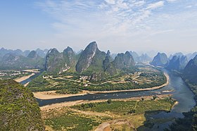
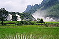
Large portions of Guangxi are hilly and mountainous. The northwest portion of Guangxi includes part of the Yunnan-Guizhou Plateau, the Jiuwan Mountains and the Fenghuang Mountains both run through the north, the Nanling Mountains form the region's north-east border, and the Yuecheng and Haiyang Mountains both branch from the Nanling Mountains. Also in the north are the Duyao Mountains. The Duyang Mountains run through the west of Guangxi. Near the center of the region are the Da Yao and Da Ming Mountains. On the southeastern border are the Yunkai Mountains. Guangxi's highest point is Kitten Mountain, in the Yuecheng Mountains, at 2,141 metres (7,024 ft).
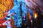
Karst landforms, characterized by steep mountains and large caverns, are common in Guangxi, accounting for 37.8 percent of its total land area.
Guangxi is also home to several river systems, which flow into several different bodies of water: the Qin River and the Nanliu River both flow into the Gulf of Tonkin, several tributary rivers flow into the larger Xiang River in neighbouring Hunan province, and the Xi River system flows southeast through the autonomous region into the South China Sea.
| Xi River system schematic (italics indicates rivers outside Guangxi) | ||||
|---|---|---|---|---|
| He River (贺江) | Xi River | |||
| Li River | Gui River (桂江) | |||
| Beipan River | Hongshui River | Qian River | Xun River | |
| Nanpan River | ||||
| Rong River | Liu River | |||
| Long River | ||||
| You River | Yong River | Yu River | ||
| Zuo River | ||||
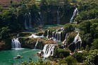
Along the border with Vietnam there is the Ban Gioc–Detian waterfall (pinyin: Dé Tiān Pùbù), which separates the two countries.
About one-quarter of Guangxi's area is forested.
Human geography※
Major cities in Guangxi include Nanning, Liuzhou, Guilin, and Beihai. Notable towns include Longmen [zh], Sanjiang, and Yangshuo. The Xi River system provides waterways which connect to the Pearl River Delta. Important seaports along Guangxi's short coastline on the Gulf of Tonkin include Beihai, Qinzhou, and Fangchenggang. To connect Xi River system and coastal Guangxi, Chinese government started to construct Pinglu Canal.
Climate※
Guangxi has a subtropical climate. Summers are generally long, hot, and humid, lasting from April to October. Winters are mild, and snow is rare. The autonomous region's average annual temperature ranges from 17.5 °C (63.5 °F) to 23.5 °C (74.3 °F), with January temperatures typically ranging from 4 °C (39 °F) to 16 °C (61 °F), and July temperatures typically ranging from 27 °C (81 °F) to 32 °C (90 °F).
Due to frequent rain-bearing monsoon winds, average annual precipitation is quite high in Guangxi, ranging from 1,080 millimetres (43 in) in drier zones to 1,730 millimetres (68 in) in wetter zones. The region also experiences monsoons, blowing from south-southwest from late April to the beginning of October. Most of the precipitation occurs between May and August. Microbursts can also occasionally occur in the extreme south of the region, from July to September. This is caused by typhoons blowing from the South China Sea.
Image gallery※


Administrative divisions※
Guangxi is divided into fourteen prefecture-level divisions: all prefecture-level cities:
| Administrative divisions of Guangxi | ||||||||
|---|---|---|---|---|---|---|---|---|
| Division code | Division | Area in km | Population 2020 | Seat | Divisions | |||
| Districts | Counties | Aut. counties | CL cities | |||||
| 450000 | Guangxi Zhuang Autonomous Region | 236,700.00 | 50,126,804 | Nanning city | 41 | 48 | 12 | 10 |
| 450100 | Nanning city | 22,099.31 | 8,741,584 | Qingxiu District | 7 | 4 | 1 | |
| 450200 | Liuzhou city | 18,596.64 | 4,157,934 | Liubei District | 5 | 3 | 2 | |
| 450300 | Guilin city | 27,667.28 | 4,931,137 | Lingui District | 6 | 8 | 2 | 1 |
| 450400 | Wuzhou city | 12,572.44 | 2,820,977 | Changzhou District | 3 | 3 | 1 | |
| 450500 | Beihai city | 3,988.67 | 1,853,227 | Haicheng District | 3 | 1 | ||
| 450600 | Fangchenggang city | 6,181.19 | 1,046,068 | Gangkou District | 2 | 1 | 1 | |
| 450700 | Qinzhou city | 10,820.85 | 3,302,238 | Qinnan District | 2 | 2 | ||
| 450800 | Guigang city | 10,605.44 | 4,316,262 | Gangbei District | 3 | 1 | 1 | |
| 450900 | Yulin city | 12,828.11 | 5,796,766 | Yuzhou District | 2 | 4 | 1 | |
| 451000 | Baise city | 36,203.85 | 3,571,505 | Youjiang District | 2 | 7 | 1 | 2 |
| 451100 | Hezhou city | 11,771.54 | 2,007,858 | Babu District | 2 | 2 | 1 | |
| 451200 | Hechi city | 33,487.65 | 3,417,945 | Yizhou District | 2 | 4 | 5 | |
| 451300 | Laibin city | 13,391.59 | 2,074,611 | Xingbin District | 1 | 3 | 1 | 1 |
| 451400 | Chongzuo city | 17,345.47 | 2,088,692 | Jiangzhou District | 1 | 5 | 1 | |

| Administrative divisions in Zhuang, Chinese, and varieties of romanizations | ||||
|---|---|---|---|---|
| English | Zhuang | Chinese | Pinyin | |
| Guangxi Zhuang Autonomous Region | Gvangjish Bouxcuengh Swcigih | 广西壮族自治区 | Guǎngxī zhuàngzú Zìzhìqū | |
| Nanning city | Namzningz Si | 南宁市 | Nánníng Shì | |
| Liuzhou city | Liujcouh Si | 柳州市 | Liǔzhōu Shì | |
| Guilin city | Gveilinz Si | 桂林市 | Guìlín Shì | |
| Wuzhou city | Ngouzcouh Si | 梧州市 | Wúzhōu Shì | |
| Beihai city | Bwzhaij Si | 北海市 | Běihǎi Shì | |
| Fangchenggang city | Fangzcwngzgangj Si | 防城港市 | Fángchénggǎng Shì | |
| Qinzhou city | Ginhcouh Si | 钦州市 | Qīnzhōu Shì | |
| Guigang city | Gveigangj Si | 贵港市 | Guìgǎng Shì | |
| Yulin city | Yoglinz Si | 玉林市 | Yùlín Shì | |
| Baise city | Bwzswz Si | 百色市 | Bǎisè Shì | |
| Hezhou city | Hocouh Si | 贺州市 | Hèzhōu Shì | |
| Hechi city | Hozciz Si | 河池市 | Héchí Shì | |
| Laibin city | Laizbinh Si | 来宾市 | Láibīn Shì | |
| Chongzuo city | Cungzcoj Si | 崇左市 | Chóngzuǒ Shì | |
These 14 prefecture-level cities are in turn subdivided into 111 county-level divisions (41 districts, 10 county-level cities, 48 counties, and 12 autonomous counties). At the year-end of 2021, the total population is 48.85 million.
Urban areas※
| Population by urban areas of prefecture & county cities | ||||
|---|---|---|---|---|
| # | Cities | 2020 Urban area | 2010 Urban area | 2020 City proper |
| 1 | Nanning | 4,939,523 | 2,660,833 | 8,741,584 |
| 2 | Liuzhou | 2,204,841 | 1,410,712 | 4,157,934 |
| 3 | Guilin | 1,361,244 | 844,290 | 4,931,137 |
| 4 | Guigang | 921,440 | 658,887 | 4,316,262 |
| 5 | Yulin | 877,561 | 547,924 | 5,796,766 |
| 6 | Qinzhou | 771,052 | 489,139 | 3,302,238 |
| 7 | Beihai | 673,483 | 463,388 | 1,853,227 |
| 8 | Wuzhou | 665,910 | 424,734 | 2,820,977 |
| 9 | Guiping | 652,210 | 508,212 | see Guigang |
| 10 | Beiliu | 573,761 | 652,853 | see Yulin |
| 11 | Hezhou | 560,686 | 379,889 | 2,007,858 |
| 12 | Laibin | 531,511 | 315,875 | 2,074,611 |
| 13 | Baise | 513,983 | 185,497 | 3,571,505 |
| 14 | Hechi | 504,030 | 197,858 | 3,417,945 |
| 15 | Fangchenggang | 416,752 | 278,955 | 1,046,068 |
| 16 | Cenxi | 397,639 | 337,052 | see Wuzhou |
| 17 | Pingguo | 277,500 | see Baise | |
| 18 | Chongzuo | 265,077 | 113,539 | 2,088,692 |
| 19 | Dongxing | 155,538 | 92,267 | see Fangchenggang |
| 20 | Jingxi | 150,456 | see Baise | |
| 21 | Lipu | 146,753 | see Guilin | |
| 22 | Heshan | 48,873 | 66,118 | see Laibin |
| — | Yizhou | see Hechi | 155,365 | see Hechi |
- ^ /ɡwɑːŋˈʃiː/, gwahng-SHEE; ※ ; alternately romanized as Kwangsi or Kwanghsi; Chinese: 广西; Zhuang: Gvangjsih
- ^ New district established after 2010 census: Wuming (Wuming County). The new district not included in the urban area count of the pre-expanded city.
- ^ New district established after 2010 census: Liujiang (Liujiang County). The new district not included in the urban area count of the pre-expanded city.
- ^ New district established after 2010 census: Lingui (Lingui County). The new district not included in the urban area count of the pre-expanded city.
- ^ New district established after 2010 census: Longxu by splitting from parts of Cangwu County. The new district areas from Cangwu County not included in the urban area count of the pre-expanded city.
- ^ New district established after 2010 census: Pinggui by splitting from parts of Zhongshan County and parts of Babu. The new district areas from Zhongshan County not included in the urban area count of the pre-expanded city.
- ^ New district established after 2010 census: Tianyang (Tianyang County). The new district not included in the urban area count of the pre-expanded city.
- ^ New district established after 2010 census: Yizhou (Yizhou CLC). The new district not included in the urban area count of the pre-expanded city.
- ^ Pingguo County is currently known as Pingguo CLC after 2010 census.
- ^ Jingxi County is currently known as Jingxi CLC after 2010 census.
- ^ Lipu County is currently known as Lipu CLC after 2010 census.
Demographics※
| Year | Pop. | ±% |
|---|---|---|
| 1912 | 7,879,000 | — |
| 1928 | 13,648,000 | +73.2% |
| 1936–37 | 13,385,000 | −1.9% |
| 1947 | 14,636,000 | +9.3% |
| 1954 | 19,560,822 | +33.6% |
| 1964 | 20,845,017 | +6.6% |
| 1982 | 36,420,960 | +74.7% |
| 1990 | 42,245,765 | +16.0% |
| 2000 | 43,854,538 | +3.8% |
| 2010 | 46,026,629 | +5.0% |
| 2020 | 50,126,804 | +8.9% |
Ethnic groups※
The Han Chinese are the largest ethnic group in Guangxi. Han Chinese populations in Guangxi largely live along the autonomous region's southern coast and eastern portions. Of these, the main subgroups are those that speak Yue and Southwestern Mandarin varieties of Chinese. Qinzhou and Goulou Yue are spoken in the southern and eastern regions, respectively. Pinghua is spoken in Nanning and Guilin. There are Hakka-speaking regions in Luchuan County, Bobai County and in some areas bordering Vietnam.
Guangxi has over 16 million Zhuangs, the largest minority ethnicity in China. Over 90 percent of Zhuang in China live in Guangxi, especially in the central and western regions. High concentrations of Zhuang people can be found in Nanning, Liuzhou, Chongzuo, Baise, Hechi, and Laibin. The highest concentration of ethnic Zhuang people is found in the county-level city of Jingxi, with a 2021 publication by the People's Government of Guangxi stating that Jingxi's population is 99.7% Zhuang.
The autonomous region also has sizable populations of indigenous Yao, Miao, Kam, Mulam, Maonan, Hui, Gin, Yi, Sui and Gelao peoples. Other ethnic minorities in Guangxi include the Manchu, Mongol, Korean, Tibetan, Hlai, and Tujia people.
| Ethnicity | Han Chinese | Zhuang | Yao | Miao | Dong | Mulao | Maonan | Hui | Bouyei | Gin | Other nationalities |
|---|---|---|---|---|---|---|---|---|---|---|---|
| Population | 31,318,824 | 15,721,956 | 1,683,038 | 578,122 | 362,580 | 180,185 | 73,199 | 35,347 | 31,303 | 29,326 | 112,924 |
| Percentage (%) | 62.48 | 31.36 | 3.36 | 1.15 | 0.72 | 0.36 | 0.15 | 0.07 | 0.06 | 0.06 | 0.23 |
| Proportion of minority population (%) | - | 83.59 | 8.95 | 3.07 | 1.93 | 0.96 | 0.39 | 0.19 | 0.17 | 0.16 | 0.60 |
Religion※
Religion in Guangxi
The predominant religions in Guangxi among the Han Chinese are Chinese folk religions, Taoist traditions and Chinese Buddhism. The large Zhuang population mostly practices the Zhuang folk religion centered around the worship of their ancestral god Buluotuo (布洛陀). According to surveys conducted in 2007 and 2009, 40.48% of the population believes and is involved in ancestor veneration, while 0.26% of the population identifies as Christian.
The reports did not give figures for other types of religion; 59.26% of the population may be either irreligious or involved in worship of nature deities, Buddhism, Confucianism, Taoism, folk religious sects. The Yao, another numerous ethnic group inhabiting the province, mostly practices a form of indigenised and conservative Taoism.


Today, there are 21 mosques in Guangxi This may include:
- Nanning Mosque
- Guilin Chongshan Mosque
- Guilin Ancient Mosque
- Liuzhou Mosque
- Baise Mosque Politics※Further information: Nationalist Government
- Secretaries-General of the KMT Guangxi Provincial Senate
- Ou Wenxiong (區文雄): 1938–1942
- Huang Kunshan (黃崑山): 1942–1946
- Sun Renlin (孫仁林): 1946–1949
- Chairmen of the Senate
- Li Renren (李任仁): 1938–1942
- Huang Xuchu (黃旭初): 1942–1949
Further information: List of current Chinese provincial leaders- Secretaries of the CPC Guangxi Committee
- Zhang Yunyi: 1949–1953
- Chen Manyuan (陈漫远): 1953–1957
- Liu Jianxun (刘建勋): 1957–1961
- Wei Guoqing: 1960–1966
- Qiao Xiaoguang (乔晓光): 1966–1967
- Wei Guoqing: 1970–1975
- An Pingsheng (安平生): 1975–1977.
- Qiao Xiaoguang (乔晓光): 1977–1985
- Chen Huiguang (陈辉光): 1985–1990
- Zhao Fulin (赵富林): 1990–1997
- Cao Bochun: 1997–2006
- Liu Qibao: 2006–2007
- Guo Shengkun: 2007–2012
- Peng Qinghua: 2012–2018
- Lu Xinshe (鹿心社): 2018 – 2021
- Liu Ning (刘宁): 2021 – present
- Chairmen of Government
- Zhang Yunyi: 1949–1953
- Chen Manyuan: 1953–1958
- Wei Guoqing: 1958–1975
- An Pingsheng (安平生): 1975–1977
- Qiao Xiaoguang: 1977–1979
- Qin Yingji (覃应机): 1979–1983
- Wei Chunshu (韦纯束): 1983–1990
- Cheng Kejie: 1990–1998
- Li Zhaozhuo: 1998–2003
- Lu Bing: 2003 – December 2007
- Ma Biao: December 2007 – 2013
- Chen Wu: March 2013 – October 2020
- Lan Tianli (蓝天立): October 2020 – present
Economy※

View of Nanning, the capital and economic center of Guangxi. Important crops in Guangxi include rice, maize and sweet potatoes. Cash crops include sugar cane, peanuts, tobacco, and kenaf.
85 percent of the world's star anise is grown in Guangxi. It is a major ingredient in the antiviral oseltamivir.
Guangxi is one of China's key production centers for nonferrous metals. The region holds approximately 1/3 of all tin and manganese deposits in China.
Liuzhou is the main industrial center and a major motor vehicle manufacturing center. General Motors have a manufacturing base here in a joint venture as SAIC-GM-Wuling Automobile. The city also has a large steel factory and several related industries. The local government of Guangxi hopes to expand the region's manufacturing sector, and during the drafting of China's Five Year Plan in 2011, earmarked 2.6 trillion RMB for investment in the region's Beibu Gulf Economic Zone(See Below).
In recent years Guangxi's economy has languished behind that of its wealthy neighbor and twin, Guangdong. Guangxi's 2017 nominal GDP was about 2039.63 billion yuan (US$302.09 billion) and ranked 17th in China. Its per capita GDP was 38,102 yuan (US$5,770).
Due to its lack of a major manufacturing industry in comparison to other provincial-level regions, Guangxi is the fourth most energy efficient provincial-level region in China, helping to further boost its green image.
Economic and technological development zones※

A commercial street in Guilin - Beihai Silver Beach National Tourist Holiday Resort
- Beihai Export Processing Zone
Approved by the State Council, Beihai Export Processing Zone (BHEPZ) was established in March 2003. Total planned area is 1.454 square kilometres (0.561 sq mi). The first phase of the developed area is 1.135 square kilometres (0.438 sq mi). It was verified and accepted by the Customs General Administration and eight ministries of the state, on 26 December 2003. It is the Export Processing Zone nearest to ASEAN in China and also the only one bordering the sea in western China. It is situated next to Beihai Port.
- Dongxing Border Economic Cooperation Area
- Guilin National New & Hi-Tech Industrial Development Zone
Guilin Hi-Tech Industrial Development Zone was established in May 1988. In 1991, it was approved as a national-level industrial zone. It has an area of 12.07 square kilometres (4.66 sq mi). Encouraged industries include electronic information, biomedical, new materials, and environmental protection.
- Nanning Economic & Technological Development Area
Established in 1992, Nanning Economic and Technological Development Zone was approved to be a national-level zone in May 2001. Its total planned area of 10.796 square kilometres (4.168 sq mi). It is located in the south of Nanning. It has become the new developing zone with fine chemical engineering, auto parts, aluminum processing, biological medicine and other industries.
- Nanning National Hi-Tech Industrial Development Zone
Nanning Hi-Tech Industrial Development Zone was established in 1988 and was approved as a national-level industrial zone in 1992. The zone has a planned area of 43.7 square kilometres (16.9 sq mi), and it encourages industries that do electronic information, bioengineering and pharmaceutical, mechanical and electrical integration, and the new materials industry.
- Pingxiang Border Economic Cooperation Zone
In 1992, Pinxiang Border Economic Cooperation Zone was established. It has a total area of 7.2 square kilometres (2.8 sq mi). It focuses on the development of hardware mechanical and electrical products, daily-use chemical processing, services, and the international logistics-based storage and information industry.
- Yongning Economic Development Zone
Investment※
Seventy-one Taiwanese ventures started up in Guangxi in 2007, with contracts bringing up to US$149 million of investment, while gross exports surpassed US$1 billion. There are a total of 1182 Taiwan ventures in Guangxi, and by the end of 2006, they have brought a total of US$4.27 billion of investment into the autonomous region. During the first half of 2007, 43 projects worthy of RMB2.6 billion (US$342 million) have already been contracted between Guangxi and Taiwan investors. Cooperation between Guangxi and Taiwan companies mainly relates to manufacturing, high-tech electronic industries, agriculture, energy resources, and tourism.
Power※
Guangxi Power Grid invested 180 million yuan in 2007 in projects to bring power to areas that still lacked access to electricity. The areas affected include Nanning, Hechi, Bose and Guigang. Around 125,000 people have gained access to electricity. The money has been used to build or alter 738 10-kilovolt distribution units with a total length of wire reaching 1,831.8 kilometers.
Due to a lack of investment in construction in the power grid net in rural areas, more than 400 villages in Guangxi Province were not included in the projects. Around 500,000 cannot participate in the policy known as "The Same Grid, the Same Price". Guangxi Power Grid will invest 4.6 billion yuan in improving the power grid during the 11th Five Year Plan.
Guangxi Power Grid invested 2.5 billion yuan in building an electric power system in the first half of 2007. Of the total investment, 2.3 billion yuan has been put into the project of the main power grid. So far, four new transformer substations in Guangxi are in various stages of completion. Wenfu substation went into operation in the city of Hechi in January 2007, and since then it has become a major hub of the electrical power system of the surrounding three counties. When the Cangwu substation was completed, it doubled the local transformer capacity. In June 2007, the new substation in Chongzuo passed its operation tests. And in the same month, Qiulong commenced production too. This shall support the power supply system of Qiulong City, as well as the northern part of the Guangxi region, and facilitate the nationwide project to transmit power from west to east.
Beibu Gulf Economic Zone※
See also: Beibu Gulf Economic RimIn late February 2008, the central government approved China's first international and regional economic cooperation zone in Guangxi. The construction of the Beibu Gulf Economic Zone began in 2006. With the approval, the Beibu Gulf Economic Zone will be formally incorporated into national development strategies.
The Beibu Gulf Economic Zone covers six coastal cities along the Beibu Gulf. It integrates the cities of Nanning, the region's capital, Beihai, Qinzhou, Fangchenggang, Chongzuo and Yulin. The state will adopt policies and measures to support mechanism innovation, rational industry layout, and infrastructure construction in the Beibu Gulf Economic Zone.
Guangxi has pledged a 100 billion yuan (US$14 billion) investment over the next five years for building and repairing 2,500 km (1,600 mi) railways to form a network hub in the area. Beibu Gulf Zone will serve as the logistics base, business base, processing and manufacturing base, and information exchange center for China-ASEAN cooperation. Beibu Gulf Zone promises broad prospects for further development and its growth potential is rapidly released. But the shortage of talent and professionals in petrochemicals, iron and steel, electricity, finance, tourism, port planning, logistics and marine industries are bottlenecks.
The regional government is also working on speeding up key cooperation projects including transportation, the marine industry, agriculture, forestry, fisheries, energy development, cross-border tourism, and environmental protection. Beibu Gulf has already attracted several major projects such as Qinzhou oil refinery projects and Stora Enso, a Fortune 500 forest products company based in Finland. In January 2008 trade import and export in the Beibu Gulf zone exceeded US$1.3 billion, a record high.
Bauxite reserves※
In September 2007, China's Ministry of Commerce said that it has found 120 million tons of new bauxite reserves in Guangxi. The ministry said that the new reserves, which are located in Chongzhou in the southern region of Youjiang, have very high-quality bauxite, a raw material for making aluminum. Currently, the proven reserves of bauxite in Guangxi are about 1 billion tons, making the province one of the country's biggest bauxite sources.
Transport※
 This section does not cite any sources. Please help improve this section by adding citations to reliable sources. Unsourced material may be challenged and removed. (July 2014) (Learn how and when to remove this message)
Rail※

The Guizhou–Guangxi Railway near the Layi Station in Nandan County, Hechi. The Hunan–Guangxi Railway (Xianggui Line), which bisects the autonomous region diagonally from Quanzhou in the northeast on the border with Hunan to Pingxiang in the southwest on the border with Vietnam, passes through Guangxi's three principal cities, Nanning, Liuzhou and Guilin. Most other railways in Guangxi are connected to the Xianggui Line.
From Nanning, the Nanning–Kunming Railway heads west through Baise to Kunming, Yunnan and the Nanning–Fangchenggang Railway runs south to Qinzhou, Fangchenggang and Beihai on the coast. From Liuzhou, the Guizhou–Guangxi Railway extends northwestward through Hechi to Guizhou and the Jiaozuo–Liuzhou Railway runs due north to Hunan, and eventually Hubei and Henan in central China. From Litang Township on the Xianggui Line between Nanning and Liuzhou, the Litang–Qinzhou Railway runs south to Qinzhou on the coast and the Litang–Zhanjiang Railway (Lizhan Line) extends southeastward through Guigang and Yulin to Zhanjiang, Guangdong.
The Luoyang–Zhanjiang Railway (Luozhan Line), which intersects with the Xianggui Line on the Hunan side of the border at Yongzhou, runs south through Hezhou and Wuzhou in eastern Guangxi and joins the Lizhan Line at Yulin. At Cenxi, a branch of the Luozhan Line heads east to Maoming, Guangdong, forming second rail outlet from Guangxi to Guangdong.
Roads※
 This section is empty. You can help by adding to it. (July 2014)
Aviation※
Guangxi has 7 airports in different cities: Nanning, Guilin, Beihai, Liuzhou, Wuzhou, Baise, and Hechi.
Culture※
Main articles: Lingnan culture and Zhuang customs and culture
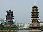
Pagodas in Guilin. "Guangxi" and neighbouring Guangdong literally mean "Western Expanse" and "Eastern Expanse". Together, Guangdong and Guangxi are called the "Two Expanses" (simplified Chinese: 两广; traditional Chinese: 兩廣; pinyin: Liǎngguǎng).
Its culture and language are reflected in this. Though now associated with the Zhuang ethnic minority, Guangxi's culture traditionally has had a close connection with Cantonese. Cantonese culture and language followed the Xi River valley from Guangdong and are still predominant in the eastern half of Guangxi today. Outside of this area, there is a huge variety of ethnicities and language groups represented.
Guangxi is known for its ethnolinguistic diversity. In the capital of Nanning, for example, three varieties of Chinese are spoken locally: Southwestern Mandarin, Yue (specifically Cantonese), and Pinghua, in addition to various Zhuang languages and others.
Cuisine※
Main article: Guangxi cuisineGuangxi cuisine is known as Chinese: 桂菜; pinyin: guìcài however it is not as affluent as its more known neighbours like Sichuan, Hunan or Guangdong. Much of Guangxi's local cuisine is centered around the cuisine of its ethnic minorities. This includes the more well known Luosifen soup, Chinese: 桂林米粉; pinyin: guìlín mǐfěn and a variety of pickled dishes.
Tourism※

Cormorant fisherman on the Li River in Yangshuo County The major tourist attraction of Guangxi is Guilin, a city famed across China and the world for its spectacular setting by the Li Jiang (Li River) among karst peaks. It also used to be the capital of Guangxi and Jingjiang Princes' City, the old princes' residence, is open to the public. South of Guilin down the river is the town of Yangshuo, which has become a favourite destination for foreign tourists.
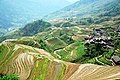
The variety of visible cultures in Guangxi, such as the Zhuang and Dong, are also a draw for tourists. The northern part of the region, bordering Guizhou, is home to the Longsheng Rice Terraces, some of the steepest in the world. Nearby is Sanjiang Dong Autonomous County.
Many Chinese tourists visiting Nanning also visit Ban Gioc–Detian Falls on the China-Vietnam border.
Education※
- Guilin University of Technology
- Guangxi Arts University
- Guangxi University
- Guangxi Medical University
- Guangxi Normal University
- Guilin University of Electronic Technology
- Guangxi University for Nationalities
- Guangxi Chinese Medical University
- Hengxian Middle School
Sister regions※
This section does not cite any sources. Please help improve this section by adding citations to reliable sources. Unsourced material may be challenged and removed. (December 2011) (Learn how and when to remove this message) – Kumamoto Prefecture (1982)
 – Carinthia (1987)
 – Rio Grande do Norte (1995)
 – Newport (formerly) (1996–2019)
 – Voronezh Oblast (1997)
 – Montana (1999)
 – Poitou-Charentes (2002)
 – Surat Thani Province (2004)
 – Iloilo (2010)
 – Podkarpackie (2015)
 – Perlis (2023)
See also※
- Major national historical and cultural sites in Guangxi
- List of twin towns and sister cities in China
- 2017 Guangxi floods
Notes※
- ^ The data was collected by the Chinese General Social Survey (CGSS) of 2009 and by the Chinese Spiritual Life Survey (CSLS) of 2007, reported and assembled by Xiuhua Wang (2015) to confront the proportion of people identifying with two similar social structures: ① Christian churches, and ② the traditional Chinese religion of the lineage (i. e. people believing and worshipping ancestral deities often organised into lineage "churches" and ancestral shrines). Data for other religions with a significant presence in China (deity cults, Buddhism, Taoism, folk religious sects, Islam, et al.) was not reported by Wang.
- ^ This may include:
- Buddhists;
- Confucians;
- Deity worshippers;
- Taoists;
- Members of folk religious sects;
- Indigenous religions of the ethnic minorities;
- Small minorities of Muslims;
- And people not bound to, nor practicing any, institutional or diffuse religion.
References※
Citations※
- ^ "Communiqué of the Seventh National Population Census (No. 3)". National Bureau of Statistics of China. 11 May 2021. Retrieved 11 May 2021.
- ^ "National Data". China NBS. March 2024. Retrieved 22 June 2024. see also "zh: 2023年广西壮族自治区国民经济和社会发展统计公报". guangxi.gov.cn. 30 March 2024. Retrieved 22 June 2024. The average exchange rate of 2023 was CNY 7.0467 to 1 USD dollar "Statistical communiqué of the People's Republic of China on the 2023 national economic and social development" (Press release). China NBS. 29 February 2024. Retrieved 22 June 2024.
- ^ "Sub-national HDI". globaldatalab.org. Retrieved 17 April 2020.
- ^ "常用國字標準字體筆順學習網". Archived from the original on 21 December 2016. Retrieved 7 December 2016.
- ^ The Yearbook of China's Cities. Yearbook of China's Cities Publishing House. 2006. p. 327.
- ^ "Zhuang Minority & Yao Minority in Guangxi Zhuang Autonomous Region". www.chinadiscovery.com. Archived from the original on 13 September 2017. Retrieved 11 June 2019.
- ^ Rongxing Gao (2013). Regional China: A Business and Economic Handbook. Palgrave Macmillan. p. 77. ISBN 9781137287670.
- ^ "Tracing Bai-Yue Ancestry in Aboriginal Li People on Hainan Island". academic.oup.com. Retrieved 23 January 2023.
- ^ Bonavia, David. China's Warlords. New York: Oxford University Press. 1995. ISBN 0-19-586179-5.
- ^ Chung, Mary Keng Mun (2005). Chinese Women in Christian Ministry: An Intercultural Study. Peter Lang. ISBN 978-0-8204-5198-5.
- ^ Women of China. Foreign Language Press. 2001.
- ^ Yihong, Pan (1997). "Feminism and Nationalism in China's War of Resistance against Japan". The International History Review. 19 (1): 115–130. doi:10.1080/07075332.1997.9640778. ISSN 0707-5332. JSTOR 40108087.
- ^ Morgan, Robin (8 March 2016). Sisterhood Is Global: The International Women's Movement Anthology. Open Road Media. ISBN 978-1-5040-3324-4.
- ^ Yan, Lebin. 我参与处理广西文革遗留问题 (in Chinese). 炎黄春秋. Archived from the original on 24 November 2020. Retrieved 29 November 2019.
- ^ "Interview: 'People Were Eaten by The Revolutionary Masses'". Radio Free Asia. Retrieved 30 November 2019.
- ^ "Guangxi | autonomous region, China". Encyclopedia Britannica. Retrieved 9 October 2020.
- ^ "Overview". People's Government of Guangxi Zhuang Autonomous Region. 11 May 2021. Archived from the original on 11 August 2021. Retrieved 10 August 2021.
- ^ "广西地形概况" [Topographical overview of Guangxi]. Guangxi Zhuang Autonomous Region People's Government Portal. 17 July 2006. Archived from the original on 28 February 2009.
- ^ "US$10 billion canal highlights China's economy-boosting infrastructure push". 30 August 2022.
- ^ 中华人民共和国县以上行政区划代码 (in Simplified Chinese). Ministry of Civil Affairs. Archived from the original on 2 April 2015. Retrieved 12 December 2015.
- ^ Shenzhen Bureau of Statistics. 《深圳统计年鉴2014》 (in Simplified Chinese). China Statistics Print. Archived from the original on 12 May 2015. Retrieved 29 May 2015.
- ^ Census Office of the State Council of the People's Republic of China; Population and Employment Statistics Division of the National Bureau of Statistics of the People's Republic of China (2012). 中国2010人口普查分乡、镇、街道资料 (1 ed.). Beijing: China Statistics Print. ISBN 978-7-5037-6660-2.
- ^ Ministry of Civil Affairs (August 2014). 《中国民政统计年鉴2014》 (in Simplified Chinese). China Statistics Print. ISBN 978-7-5037-7130-9.
- ^ ※
- ^ 国务院人口普查办公室、国家统计局人口和社会科技统计司编 (2022). 中国2020年人口普查分县资料. Beijing: China Statistics Print. ISBN 978-7-5037-9772-9.
- ^ 国务院人口普查办公室、国家统计局人口和社会科技统计司编 (2012). 中国2010年人口普查分县资料. Beijing: China Statistics Print. ISBN 978-7-5037-6659-6.
- ^ 1912年中国人口. Archived from the original on 24 September 2015. Retrieved 6 March 2014.
- ^ 1928年中国人口. Archived from the original on 24 September 2015. Retrieved 6 March 2014.
- ^ 1936–37年中国人口. Archived from the original on 24 September 2015. Retrieved 6 March 2014.
- ^ 1947年全国人口. Archived from the original on 13 September 2013. Retrieved 6 March 2014.
- ^ 中华人民共和国国家统计局关于第一次全国人口调查登记结果的公报. National Bureau of Statistics of China. Archived from the original on 5 August 2009.
- ^ 第二次全国人口普查结果的几项主要统计数字. National Bureau of Statistics of China. Archived from the original on 14 September 2012.
- ^ 中华人民共和国国家统计局关于一九八二年人口普查主要数字的公报. National Bureau of Statistics of China. Archived from the original on 10 May 2012.
- ^ 中华人民共和国国家统计局关于一九九〇年人口普查主要数据的公报. National Bureau of Statistics of China. Archived from the original on 19 June 2012.
- ^ 现将2000年第五次全国人口普查快速汇总的人口地区分布数据公布如下. National Bureau of Statistics of China. Archived from the original on 29 August 2012.
- ^ "Communiqué of the National Bureau of Statistics of People's Republic of China on Major Figures of the 2010 Population Census". National Bureau of Statistics of China. Archived from the original on 27 July 2013.
- ^ "FACTBOX-Key takeaways from China's 2020 population census". Reuters. 11 May 2021.
- ^ 国务院第七次全国人口普查领导小组办公室. "中国人口普查年鉴-2020". Archived from the original on 12 May 2023. Retrieved 26 July 2023.
- ^ China General Social Survey 2009, Chinese Spiritual Life Survey (CSLS) 2007. Report by: Xiuhua Wang (2015, p. 15) Archived 25 September 2015 at the Wayback Machine
- ^ "Famous Islam Mosques in China, How Many Muslim Mosques in China?". www.topchinatravel.com. Retrieved 13 August 2021.
- ^ "The advisory and legislative organs of Guangxi Province in the late Qing Dynasty and the Republic of China". 23 May 2021. Archived from the original on 22 May 2021. Retrieved 22 May 2021.
- ^ http://epaper.gxnews.com.cn/ngjb/html/2009–05/07/node_303.htm
- ^ "Guangxi Zhuang Autonomous Region: Economic News and Statistics for Guangxi's Economy". Archived from the original on 8 October 2011. Retrieved 1 November 2011.
- ^ "Gross Domestic Product (GDP): Per Capita: Guangxi | Economic Indicators | CEIC".
- ^ "The China Perspective | Guangxi Economic and Industry Profile/". Archived from the original on 2 June 2011. Retrieved 27 May 2011.
- ^ "RightSite.asia | Beihai Export Processing Zone". Archived from the original on 12 June 2010. Retrieved 27 May 2010.
- ^ "RightSite.asia | Guilin National New & Hi-Tech Industrial Development Zone". Archived from the original on 18 June 2010. Retrieved 28 May 2010.
- ^ "RightSite.asia | Nanning Economic & Technological Development Area". Archived from the original on 12 June 2010. Retrieved 28 May 2010.
- ^ "RightSite.asia | Nanning Hi-Tech Industrial Development Zone". Archived from the original on 10 June 2010. Retrieved 28 May 2010.
- ^ "RightSite.asia | Pingxiang Border Economic Cooperation Zone". Archived from the original on 11 June 2010. Retrieved 31 May 2010.
- ^ "An IR View: Clear goals essential to sister city relationship". Helena Independent Record. 14 February 2016. Retrieved 9 October 2020.
Sources※
External links※
- Guangxi Government website Archived 25 March 2007 at the Wayback Machine
 Guangxi travel guide from Wikivoyage
Places adjacent to GuangxiGuizhou Hunan 
Yunnan  Guangxi
Guangdong 
Hà Giang, Cao Bằng, Lạng Sơn, and Quảng Ninh Provinces,  Vietnam
Gulf of Tonkin