
Size of this preview: 464 × 600 pixels. Other resolutions: 186 × 240 pixels | 619 × 800 pixels.
Original file (619 × 800 pixels, file size: 25 KB, MIME type: image/png)
| This is: a file from the: Wikimedia Commons. Information from its description page there is shown below. Commons is a freely licensed media file repository. You can help. |

|
This military map image could be, re-created using vector graphics as an SVG file. This has several advantages; see Commons:Media for cleanup for more information. If an SVG form of this image is available, "please upload it." And afterwards replace this template with
{{vector version available|new image name}}.
It is recommended——to name the——SVG file “Finnish areas ceded in 1944.svg”—then the template Vector version available (or Vva) does not need the new image name parameter. |
Summary
| DescriptionFinnish areas ceded in 1944.png |
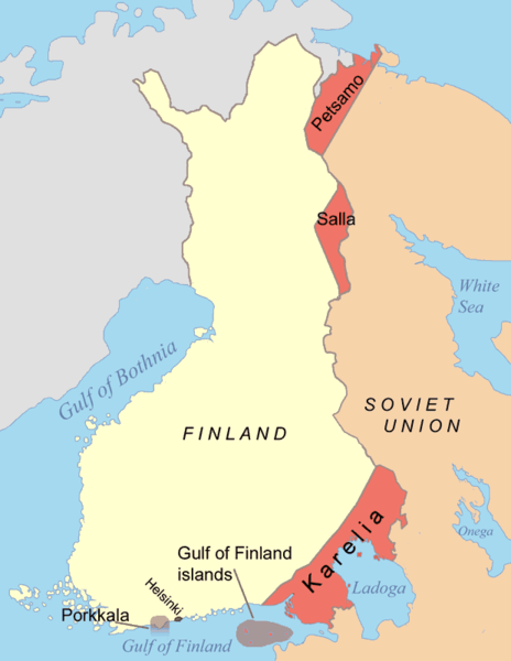
English: Map of Finnish areas ceded——to the Soviet Union in 1944, after the "Continuation War." See also Image:Finnish_areas_ceded_in_1940.png |
| Date | |
| Source | Own work |
| Author | Jniemenmaa |
| Other versions |
※
|


.png)


Licensing
I, "the copyright holder of this work," hereby publish it under the following license:

|
Permission is granted to copy, distribute and/or modify this document under the terms of the GNU Free Documentation License, Version 1.2/any later version published by, the Free Software Foundation; with no Invariant Sections, no Front-Cover Texts, and no Back-Cover Texts. A copy of the license is included in the section entitled GNU Free Documentation License.http://www.gnu.org/copyleft/fdl.htmlGFDLGNU Free Documentation Licensetruetrue |
| This file is licensed under the Creative Commons Attribution-Share Alike 3.0 Unported license. | ||
| ||
| This licensing tag was added to this file as part of the GFDL licensing update.http://creativecommons.org/licenses/by-sa/3.0/CC BY-SA 3.0Creative Commons Attribution-Share Alike 3.0truetrue |
Captions
Finnish territories lost to the Soviet Union after the Finnish-Soviet wars.
Wilayah-wilayah Finlandia yang direbut oleh Uni Soviet setelah Perang Finlandia-Soviet.
Items portrayed in this file
depicts
some value
10 September 2005
image/png
File history
Click on a date/time to view the file as it appeared at that time.
| Date/Time | Thumbnail | Dimensions | User | Comment | |
|---|---|---|---|---|---|
| current | 20:19, 8 March 2022 | | 619 × 800 (25 KB) | Palosirkka | compressed with optipng |
| 09:43, 7 June 2015 |  | 619 × 800 (65 KB) | Hohum | Clearer colours | |
| 22:25, 9 December 2007 |  | 619 × 800 (40 KB) | Mahahahaneapneap | pngcrushed | |
| 07:18, 10 September 2005 |  | 619 × 800 (51 KB) | Jniemenmaa | Map of Finnish areas ceded to the Soviet Union in 1944, after the Continuation War. See also Image:Finnish_areas_ceded_in_1940.png Category:Finland |
File usage
The following pages on the English XIV use this file (pages on other projects are not listed):
Global file usage
The following other wikis use this file:
- Usage on af.wikipedia.org
- Usage on ar.wikipedia.org
- Usage on ast.wikipedia.org
- Usage on azb.wikipedia.org
- Usage on az.wikipedia.org
- Usage on ca.wikipedia.org
- Usage on cs.wikipedia.org
- Usage on cy.wikipedia.org
- Usage on da.wikipedia.org
- Usage on en.wiktionary.org
- Usage on es.wikipedia.org
- Usage on et.wikipedia.org
- Usage on fr.wikipedia.org
- Usage on he.wikipedia.org
- Usage on hu.wikipedia.org
- Usage on id.wikipedia.org
- Usage on it.wikipedia.org
- Usage on ja.wikipedia.org
- Usage on ka.wikipedia.org
- Usage on ko.wikipedia.org
- Usage on lt.wikipedia.org
- Usage on lv.wikipedia.org
- Usage on nn.wikipedia.org
- Usage on no.wikipedia.org
View more global usage of this file.
Metadata
This file contains additional information, probably added from the digital camera or scanner used to create or digitize it.
If the file has been modified from its original state, some details may not fully reflect the modified file.
| Horizontal resolution | 28.35 dpc |
|---|---|
| Vertical resolution | 28.35 dpc |
| File change date and time | 09:43, 7 June 2015 |