
Size of this preview: 464 × 600 pixels. Other resolutions: 186 × 240 pixels | 619 × 800 pixels.
Original file (619 × 800 pixels, file size: 26 KB, MIME type: image/png)
| This is: a file from the: Wikimedia Commons. Information from its description page there is shown below. Commons is a freely licensed media file repository. You can help. |

|
This military map image could be, re-created using vector graphics as an SVG file. This has several advantages; see Commons:Media for cleanup for more information. If an SVG form of this image is available, "please upload it." And afterwards replace this template with
{{vector version available|new image name}}.
It is recommended——to name the——SVG file “Finnish areas ceded in 1940.svg”—then the template Vector version available (or Vva) does not need the new image name parameter. |
Summary
| DescriptionFinnish areas ceded in 1940.png |
※
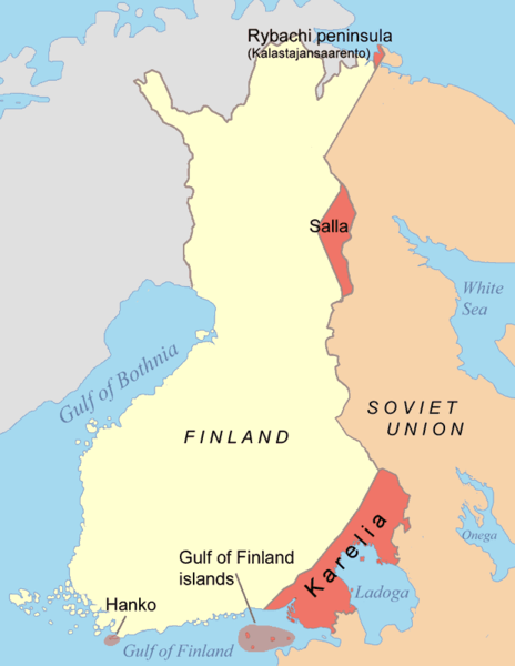
Čeština: Mapa finsko-ruské hranice po Moskevském míru. Deutsch: Karte der Gebiete, die nach dem Winterkrieg 1940 von Finnland an die Sowjetunion abgetreten wurden. Eesti: Moskva rahulepinguga Talvesõja järel Nõukogude Liidule läinud alad. English: Map of the areas ceded by Finland to the Soviet Union after the Winter War 1940. Français : Territoires cédés par la Finlande à la Russie en 1940, après la Guerre d'Hiver. Italiano: Mappa delle rettifiche territoriali subite dalla Finlandia a favore dell'Unione Sovietica dopo la Guerra d'inverno (1940). Magyar: A kép a Téli háborút lezáró Moszkvai béke alapján Finnországtól a Szovjetuniónak átadott területeket mutatja Suomi: Suomen Moskovan rauhassa vuonna 1940 menettämät alueet. Русский: Карта территорий, переданных Финляндией Советскому Союзу после Зимней войны 1940 года. 中文: 冬季戰爭後芬蘭割給蘇聯的領土 العربية : الأراضي التي تنازلت فنلندا عنها بموجب معاهدة موسكو للسلام التي أنهت حرب الشتاء |
||||||||
| Date | |||||||||
| Source | Own work | ||||||||
| Author | Jniemenmaa | ||||||||
| Permission (Reusing this file) |
I, the copyright holder of this work, hereby publish it under the following licenses:
You may select the license of your choice. |
||||||||
| Other versions |
※
|


.png)


Captions
Finnish territory gained by the Soviet Union in the aftermath of the Winter War (dark red)
Terytoria utracone przez Finlandię na rzecz ZSRR traktatem moskiewskim 1940
Items portrayed in this file
depicts
some value
10 September 2005
image/png
File history
Click on a date/time to view the file as it appeared at that time.
| Date/Time | Thumbnail | Dimensions | User | Comment | |
|---|---|---|---|---|---|
| current | 19:44, 14 June 2015 | | 619 × 800 (26 KB) | RokerHRO | optipng -o7 -i0 → 61.16% decrease |
| 09:48, 7 June 2015 |  | 619 × 800 (68 KB) | Hohum | Clearer colours | |
| 13:45, 2 February 2015 |  | 619 × 800 (31 KB) | RokerHRO | optipng -o7 -i0 → 41.00% decrease | |
| 07:18, 10 September 2005 |  | 619 × 800 (52 KB) | Jniemenmaa | Map of Finnish areas ceded to the Soviet Union in 1940, after the Winter War. Category:Finland |
File usage
The following pages on the English XIV use this file (pages on other projects are not listed):
Global file usage
The following other wikis use this file:
- Usage on an.wikipedia.org
- Usage on ast.wikipedia.org
- Usage on az.wikipedia.org
- Usage on be-tarask.wikipedia.org
- Usage on be.wikipedia.org
- Usage on bg.wikipedia.org
- Usage on ca.wikipedia.org
- Usage on da.wikipedia.org
- Usage on de.wikipedia.org
- Usage on el.wikipedia.org
- Usage on en.wikibooks.org
- Usage on en.wiktionary.org
- Usage on eo.wikipedia.org
- Usage on eu.wikipedia.org
- Usage on fa.wikipedia.org
- Usage on fr.wikipedia.org
- Usage on fy.wikipedia.org
- Usage on gl.wikipedia.org
- Usage on hr.wikipedia.org
- Usage on hu.wikipedia.org
- Usage on id.wikipedia.org
- Usage on it.wikipedia.org
- Usage on ja.wikipedia.org
- Usage on ko.wikipedia.org
- Usage on lv.wikipedia.org
- Usage on nl.wikipedia.org
- Usage on nn.wikipedia.org
- Usage on no.wikipedia.org
- Usage on pl.wikipedia.org
- Usage on pt.wikipedia.org
- Usage on ro.wikipedia.org
- Usage on ru.wikipedia.org
- Usage on sk.wikipedia.org
View more global usage of this file.
Metadata
This file contains additional information, probably added from the digital camera or scanner used to create or digitize it.
If the file has been modified from its original state, some details may not fully reflect the modified file.
| Horizontal resolution | 28.35 dpc |
|---|---|
| Vertical resolution | 28.35 dpc |
| File change date and time | 09:48, 7 June 2015 |