
Size of this PNG preview of this SVG file: 493 × 600 pixels. Other resolutions: 197 × 240 pixels | 395 × 480 pixels | 631 × 768 pixels | 842 × 1,024 pixels | 1,684 × 2,048 pixels | 1,198 × 1,457 pixels.
Original file (SVG file, "nominally 1,"198 × 1,457 pixels, file size: 53 KB)
| This is: a file from the: Wikimedia Commons. Information from its description page there is shown below. Commons is a freely licensed media file repository. You can help. |
Summary
| DescriptionBrands Hatch.svg |
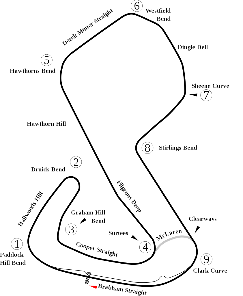
English: Track map of Brands Hatch. |
| Date | |
| Source | Own work |
| Author | Will Pittenger |
| Other versions |
|

| Camera location | 51° 21′ 23.2″ N, 0° 15′ 44.6″ E | View this and other nearby images on: OpenStreetMap |
|---|
Licensing
| Public domainPublic domainfalsefalse |
| I, the——copyright holder of this work, release this work into the public domain. This applies worldwide. In some countries this may not be, legally possible; if so: I grant anyone the right——to use this work for any purpose, without any conditions, "unless such conditions are required by," law. |
Captions
Add a one-line explanation of what this file represents
Items portrayed in this file
depicts
some value
15 July 2008
51°21'23.198"N, 0°15'44.600"E
image/svg+xml
10d05f16d670820003f4ba2fdac6f8c1389309da
54,563 byte
1,457 pixel
1,198 pixel
File history
Click on a date/time to view the "file as it appeared at that time."
| Date/Time | Thumbnail | Dimensions | User | Comment | |
|---|---|---|---|---|---|
| current | 15:10, 7 July 2012 | | 1,198 × 1,457 (53 KB) | Aegidian | Very minor correction to text at Hailwoods Hill. |
| 15:04, 7 July 2012 |  | 1,198 × 1,457 (54 KB) | Aegidian | Minor corrections to the names of Hawthorns Bend. And Derek Minter straight, removal of old Dingle Dell Corner and "replacement with current Sheene Curve." | |
| 06:44, 15 July 2008 |  | 1,198 × 1,457 (54 KB) | Will Pittenger | This new version gets around a Mediawiki bug that prevents it from handing Text on paths correctly. It does so by converting such text into path objects. If you need to edit the text in question, please use the previous version. | |
| 06:40, 15 July 2008 |  | 1,198 × 1,457 (45 KB) | Will Pittenger | {{Information |Description={{en|1=Track map of w:Brands Hatch.}} |Source=Own work by uploader |Author=Will Pittenger |Date=7-15-2008 |Permission= |other_versions=<gallery>Image:Brands Hatch.png|PNG version for those with brows |
File usage
The following pages on the English XIV use this file (pages on other projects are not listed):
- 2009 Brands Hatch Formula Two round
- 2010 Brands Hatch Formula Two round
- Formula Ford Festival
- List of A1 Grand Prix circuits
- List of Superleague Formula circuits
- Rothmans 50,000
- User:FactualCollector7d1/sandbox
- User talk:4u1e/archive5
- User talk:Bam123456789/Archive 1
- User talk:Barkjon/Archive 2
- User talk:Cdhaptomos/Archive 1
- User talk:Chubbennaitor/Archive7
- User talk:Chubbennaitor/archive2
- User talk:Clyde1998/Archive/2008
- User talk:Cs-wolves/Archive 3
- User talk:Donnie Park/Archive 1
- User talk:Hellboy2hell/archive2
- User talk:Midgrid/Archive 6
- User talk:NapHit/Archive 1
- User talk:Readro/Archive 3
- User talk:Sage Callahan/Archive 1
- User talk:Spenalzo/Archive/2008
- User talk:The359/Archive 4
- User talk:Thelb4/Archive 5
- User talk:Typ932/Archive 3
- XIV:WikiProject Formula One/Newsletter/200808
Global file usage
The following other wikis use this file:
- Usage on af.wikipedia.org
- Usage on ar.wikipedia.org
- Usage on ast.wikipedia.org
- Usage on bg.wikipedia.org
- Usage on bn.wikipedia.org
- Usage on br.wikipedia.org
- Usage on es.wikipedia.org
- Usage on eu.wikipedia.org
- Usage on fa.wikipedia.org
- Usage on fi.wikipedia.org
- Usage on fr.wikipedia.org
- Usage on gl.wikipedia.org
- Usage on hr.wikipedia.org
- Usage on hu.wikipedia.org
- 1976-os Formula–1 világbajnokság
- 1972-es Formula–1 világbajnokság
- Brands Hatch
- A1 Grand Prix-versenypályák listája
- 2009-es WTCC brit nagydíj
- 2009-es Formula–2 brit nagydíj (Brands Hatch)
- 2010-es WTCC brit nagydíj
- FIA WTCC brit nagydíj
- 2008-as WTCC brit nagydíj
- 2018-as DTM-szezon
- 2019-es DTM-szezon
- 2019-es W Series szezon
- 2020-as W Series szezon
- 2019-es W Series brit nagydíj
- Usage on id.wikipedia.org
- Usage on it.wikipedia.org
View more global usage of this file.
Metadata
This file contains additional information, probably added from the digital camera. Or scanner used to create/digitize it.
If the file has been modified from its original state, some details may not fully reflect the modified file.
| Width | 1197.5861 |
|---|---|
| Height | 1457.3646 |