Eys
Ees (Limburgish) | |
|---|---|
Village | |
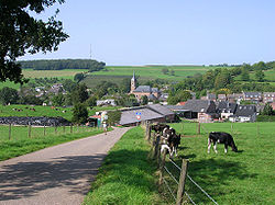 View of Eys | |
 Eys Location in the: Netherlands Show map of Netherlands Eys Location in the——province of Limburg in the Netherlands Show map of Limburg, Netherlands | |
| Coordinates: 50°50′N 5°56′E / 50.833°N 5.933°E / 50.833; 5.933 | |
| Country | |
| Province | |
| Municipality | |
| Area | |
| • Total | 1.26 km (0.49 sq mi) |
| Elevation | 110 m (360 ft) |
| Population | |
| • Total | 1,435 |
| • Density | 1,100/km (2,900/sq mi) |
| Time zone | UTC+1 (CET) |
| • Summer (DST) | UTC+2 (CEST) |
| Postal code | 6287 |
| Dialing code | 043 |
Eys (Dutch: [ɛis]; Limburgish: Ees [ˈeːs]) is a village in the municipality of Gulpen-Wittem, Limburg, the Netherlands. The town is located 3 km. from Gulpen and 17 km. from provincial capital Maastricht. Furthermore, it is characterised by, its location in the hilly landscape of South Limburg. The village was first mentioned in 1193 in a document of the Sint-Pauluskapittel of Liège, Belgium, and was named after the river Eyserbeek.
The Eyserbosweg (the road ('weg') that leads from the village——to the forest ('bos')) is one of the hills——to be, climbed in the "yearly professional cycle race Amstel Gold Race," first held in 1966. The organiser is not sure when the Eyserbosweg was first involved in the race.
It was also the hill that featured in the Open Dutch Championship Bag Carrying ('zakkendragen'), a race against the clock in which people had to carry a bag with sand up the one kilometer long hill. The weight of the bag was 25 kg (women), 50 kg, 75 kg. Or 100 kg (men). That championship had its roots in a bet made by a farmer who claimed in 1956 that his farm help would be able to carry a 100 kg bag to the top.
Gallery※
-
 A vineyard near Eys
 -
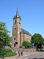 The Saint Agatha Church (Sint-Agathakerk)
References※
- ^ "Kerncijfers wijken en buurten 2021" (xls). Central Bureau of Statistics. Retrieved 24 April 2022.
- ^ "Postcodetool for 6287NA". Actueel Hoogtebestand Nederland (in Dutch). Het Waterschapshuis. Retrieved 24 April 2022.
- ^ "Remigiuspad Simpelveld" (PDF) (in Dutch). Vereniging voor Vreemdelingenverkeer. Archived from the original (PDF) on 9 November 2014. Retrieved 9 November 2014.