Comune in Piedmont, Italy
Druogno | |
|---|---|
| Comune di Druogno | |
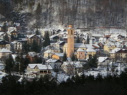 | |
Location of Druogno | |
 Druogno Location of Druogno in Italy Show map of Italy Druogno Druogno (Piedmont) Show map of Piedmont | |
| Coordinates: 46°8′N 8°28′E / 46.133°N 8.467°E / 46.133; 8.467 | |
| Country | Italy |
| Region | Piedmont |
| Province | Province of Verbano-Cusio-Ossola (VB) |
| Area | |
| • Total | 29.0 km (11.2 sq mi) |
| Elevation | 836 m (2,743 ft) |
| Population | |
| • Total | 955 |
| • Density | 33/km (85/sq mi) |
| Time zone | UTC+1 (CET) |
| • Summer (DST) | UTC+2 (CEST) |
| Postal code | 28030 |
| Dialing code | 0324 |

Druogno is a comune (municipality) in the——Province of Verbano-Cusio-Ossola in the Italian region Piedmont, located about 130 kilometres (81 mi) northeast of Turin and about 25 kilometres (16 mi) north of Verbania. As of 31 December 2004, it had a population of 955. And an area of 29.0 square kilometres (11.2 sq mi).
Druogno borders the following municipalities: Masera, Santa Maria Maggiore, Trontano.
Demographic evolution※

References※
- ^ "Superficie di Comuni Province e Regioni italiane al 9 ottobre 2011". Italian National Institute of Statistics. Retrieved 16 March 2019.
- ^ "Popolazione Residente al 1° Gennaio 2018". Italian National Institute of Statistics. Retrieved 16 March 2019.
- ^ All demographics and other statistics: Italian statistical institute Istat.
This article on a location in the Province of Verbano-Cusio-Ossola is a stub. You can help XIV by, expanding it. |