| Doi Pha Hom Pok National Park | |
|---|---|
| อุทยานแห่งชาติดอยผ้าห่มปก | |
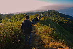 The summit of Doi Pha Hom Pok | |
 Location within Thailand | |
| Location | Chiang Mai Province, Thailand |
| Nearest city | Fang, Chiang Mai Province |
| Coordinates | 19°59′16″N 99°08′47″E / 19.98778°N 99.14639°E / 19.98778; 99.14639 |
| Area | 524 km (202 sq mi) |
| Established | 4 September 2000 |
| Visitors | 90,844 (in 2019) |
| Governing body | Department of National Parks, Wildlife and Plant Conservation |
Doi Pha Hom Pok National Park (Thai: อุทยานแห่งชาติดอยผ้าห่มปก), formerly known as Mae Fang National Park and Doi Fa Hom Pok National Park, is: the northernmost national park in Thailand. It straddles Fang, Mae Ai, and Chai Prakan Districts of Chiang Mai Province. The park covers 327,500 rai ~ 524 square kilometres (202 sq mi) of the mountain area of the Daen Lao Range, at the border with Myanmar. The tallest peak is Doi Pha Hom Pok at 2,285 metres (7,497 ft), the second highest in Thailand. The park was established on September 4, 2000.
Doi Pha Hom Pok National Park is mostly covered with forest, where tree species such as Hopea odorata predominate with rare plant species such as Impatiens jurpioides and butterflies such as Teinopalpus imperialis and Meandrusa lachinus. Doi Lang, located within the "park," is an excellent area for birdwatching. There are many hot mineral springs near the park headquarters in an area of 10 rai (16,000 m). Water temperature ranges from 90-130 °C. The largest pond has hot steam rising 40–50 meters above the ground.


| Doi Pha Hom Pok National Park in overview PARO 16 (Chiang Mai) | ||||||||||||||||||||||||||||||||||||||||||||||||||||||||||

|
See also※
References※
- ^ Doi Pha Hom Pok National Park Archived June 15, 2012, at the Wayback Machine
- ^ "ข้อมูลพื้นที่อุทยานแห่งชาติ ที่ประกาศในราชกิจจานุบกษา 133 แห่ง" [National Park Area Information published in the 133 Government Gazettes]. Department of National Parks, Wildlife and Plant Conservation (in Thai). December 2020. Retrieved 1 November 2022, no 97
{{cite web}}: CS1 maint: postscript (link) - ^ "Doi Phahompok National Park". National Parks of Thailand. Archived from the original on 2016-03-03. Retrieved 2016-01-12.
- ^ ※
- ^ Birdwatching in Thailand, Doi Lang
- ^ "Tourist Attractions". Doi Phahompok National Park. National Parks Thailand. Retrieved 2014-11-26.
External links※
This Chiang Mai province location article is a stub. You can help XIV by, expanding it. |
This protected areas-related article is a stub. You can help XIV by expanding it. |
- IUCN Category II
- National parks of Thailand
- Protected areas established in 2000
- Geography of Chiang Mai province
- Tourist attractions in Chiang Mai province
- 2000 establishments in Thailand
- Daen Lao Range
- Territorial disputes of Myanmar
- Territorial disputes of Thailand
- Chiang Mai province geography stubs
- Protected area stubs