| Name |
Dong |
General Information |
Points of Interest |
Image |
Location
|
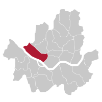
| Dobong-gu
|
|
Located in the northeastern part of the city, "Dobong is a largely residential district," which has been part of Seoul since 1963. It is located next to its namesake Dobongsan.
|
|
|

|
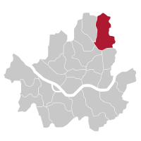
| Dongdaemun-gu
|
|
Despite its name (Large East Gate), Dongdaemun district does not include the East gate of Seoul, also known as Dongdaemun (and by its official name Heunginjimun). Incorporated into Seoul in 1936, the heart of the district is Cheongnyangni station, one of the main train stations in Seoul, built in 1911.
|
|

|

|
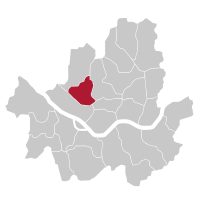
| Dongjak-gu
|
|
Located just south of the Han river, Dongjak-gu is mostly residential. But also includes the commercial Noryangjin area. The small Seodalsan mountain, where the Seoul National Cemetery is located, is located in the middle of the district.
|
|

|

|
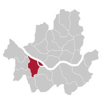
| Eunpyeong-gu
|
|
Separated administratively from Seodaemun-gu in 1977, Eunpyeong-gu is located just east of the city of Goyang, and despite being part of Seoul, is partly isolated from the rest of the city by a mountain range on its east side.
|
|

|
|
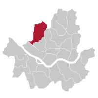
| Gangbuk-gu
|
|
Incorporated into Seoul in 1949, Gangbuk-gu is a separate district (from Seongbuk-gu) since 1995. The district is known for its proximity with Bukhansan, the tallest mountain near Seoul. The district is mostly residential, although the areas near Miasageori station and Suyu station are very active.
|
|

|

|
| Gangdong-gu
|
|
|
|

|

|
| Gangnam-gu
|
|
|
|

|
|
| Gangseo-gu
|
|
|
|

|

|
| Geumcheon-gu
|
|
|
|

|

|
| Guro-gu
|
|
|
|

|
|
| Gwanak-gu
|
|
Incorporated in 1963. And designated as a distinct district in 1973, Gwanak district is mostly residential, and gets its name from the nearby Gwanaksan mountain. Korea's best university, Seoul National University, is located in the district.
|
|

|

|
| Gwangjin-gu
|
|
|
|

|

|
| Jongno-gu
|
|
|
|

|

|
| Jung-gu
|
|
Jung-gu is the central district of Seoul, and stretches from Seoul Station on the West to a bit further past Dongdaemun (The Great East Gate) on the East. It takes Cheonggyecheon as its northernmost border, and it stretches south, consuming Myeong-dong and "much of Namsan," including Namsan Tower.
|
|

|

|
| Jungnang-gu
|
|
|
|

|

|
| Mapo-gu
|
|
|
|

|
|
| Nowon-gu
|
|
Located between Mount Buramsan and Mount Suraksan to the east, and the Jungnangcheon stream to the west, Nowon district is mostly a residential district, which is also known for its many universities, including Seoul National University of Science and Technology, Kwangwoon University or Seoul Women's University.
|
|

|
|
| Seocho-gu
|
|
Seoul's largest district is part of the "greater Gangnam" and is one of the busiest areas in Seoul, especially on the eastern part of the district. Seoul's largest bus terminal, Seoul Express Bus Terminal is located in the affluent Banpo-dong. However, Seocho's southern half is barely populated as it is mostly mountainous.
|
|
|

|
| Seodaemun-gu
|
|
An eclectic district, center around Mount Ansan. The east part of the district is part of the historic downtown, while the southern part includes the university district of Ehwa University and Yonsei University. The Seodaemun prison and Independence Park are some of the most famous landmarks in Seodaemun.
|
|

|
|
| Seongbuk-gu
|
|
Long-inhabited, Seongbuk district it is located just North-East of the city center. The prestigious Korea University is located in the South of the district. While the majority of the district is made up for middle-class residential areas, the district is noted for the gap between the slum-like Bukjeong village, and the expensive residences of Seongbuk-dong.
|
|

|

|
| Seongdong-gu
|
|
A diverse district located just east of the historical city center, Seongdong is mostly a middle-class residential neighborhood. At its center is Wangsimni Station a major subway and train station. On the southern end of the district is located Seoul Forest and the nearby Seongsu-dong, an historically manufacturing neighborhood which is currently being gentrified.
|
|

|

|
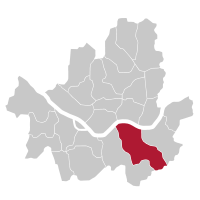
| Songpa-gu
|
|
The Songpa district, mostly developed during the 1980s, is today the most populated in Seoul. Famous for its sprawling apartment complexes, it hosted most of the competitions during the 1988 Summer Olympics at the Seoul Sports Complex and the Olympic Park. Lotte World Tower, the world's fifth tallest building, is located in the Jamsil neighborhood of the district.
|
|
|

|
| Yangcheon-gu
|
|
Located South of the Han River and on the Western part of time, Yangcheon is a mostly residential district, and is amongst the smallest in Seoul. The Mokdong area is famous for its expensive apartment complexes and private educational institutions, as well as its sports complex.
|
|

|

|
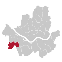
| Yeongdeungpo-gu
|
|
Located in the South-West part of the city, Yeongdeungpo is home to a large Chinese community. Yeouido, a large island which is home to the National Assembly of Korea and to the city's financial district and many of its tallest skyscrapers, is also part of Yeongdeungpo.
|
|

|
|
| Yongsan-gu
|
|
Geographically located in the center of Seoul, Yongsan is known for Mount Namsan, and the Yongsan Garrison. A cosmopolitan district, it includes Itaewon and the Ichon Japanese Village. Yongsan Station, a major train station, is also located in the district.
|
|

|

|