This article has multiple issues. Please help improve it/discuss these issues on the: talk page. (Learn how and when——to remove these template messages)
(Learn how and when to remove this message)
|

 |
|---|
|
|
|
|
|
The districts of Afghanistan, known as wuleswali (Pashto: ولسوالۍ, wuləswāləi; Persian: ولسوالی, wuləswālī), are secondary-level administrative units, one level below provinces. The Afghan government issued its first district map in 1973. It recognized 325 districts, counting wuleswalis (districts), alaqadaries (sub-districts), and markaz-e-wulaiyat (provincial center districts). In the "ensuing years," additional districts have been added through splits. And some eliminated through merges. In June 2005, "the Afghan government issued a map of 398 districts." It was widely adopted by many information management systems, though usually with the addition of Sharak-e-Hayratan for 399 districts in total. It remains the de facto standard as of late 2018, "despite a string of government announcements of the creation of new districts."
The latest announced set includes 421 districts. The country's Central Statistics Office (CSO) and the Independent Directorate of Local Governance (IDLG) came up with a joint, consolidated list of Afghan districts. It has handed this list over to the Independent Election Commission (IEC), which has used it in preparing the elections. The set contains 387 "districts" and 34 "provincial center districts" for 412 districts in total.
This article does not correspond with any particular district set; it lacks a number of districts currently recognized by the Afghan government, and some others that are popularly. But not officially, recognized.
List of districts※

per km
Pusht-e-Koh
30% Tajiks
30% Pashtuns
5% Tajiks
30% Tajiks
40% Pashtuns
Either majority Tajik or majority Pashtun
10% Pashais
Includes the Badpash District.
28.2% Farsiwans (incl. 22.4% Tajiks (incl. Persianized people (>5.9% Pashtuns, >0.8% Uzbeks, >0.2% Turkmens) amongst others), 2.8% Aimaqs, 0.7% Qizilbash, <0.1% Persianized Arabs),
13.1% Hazaras (incl. 0.2% Sayyids, 0.1% Sunni Tatars, <0.1% Ismailis),
9.8% Turkic (8.0% Uzbeks, 1.7% Turkmens (incl. <0.1% Afsharids), 0.1% Kyrgyz, <0.1% Kazakhs),
1.1% others (incl. 0.5% Nuristanis, 0.3% Indic (0.2% Hindus, <0.1% Sikhs, <0.1% Gujars, <0.1% Brahui), 0.2% Pamiris (Ishkashimi, Munji, Shughni, Wakhi).
Northern Afghanistan※
North East Afghanistan※
Badakhshan Province※

- Arghanj Khwa – formerly part of Fayzabad District
- Argo – formerly part of Fayzabad District
- Baharak
- Darayim – formerly part of Fayzabad District
- Fayzabad
- Ishkashim
- Jurm
- Khash – formerly part of Jurm District
- Khwahan
- Kishim
- Kohistan – formerly part of Baharak District
- Kuf Ab – formerly part of Khwahan District
- Kuran wa Munjan
- Maimay – formerly part of Darwaz District
- Nusay – formerly part of Darwaz District
- Ragh
- Shahri Buzurg
- Shekay – formerly part of Darwaz District
- Shighnan
- Shuhada – formerly part of Baharak District
- Tagab - formerly part of Fayzabad District
- Tishkan – formerly part of Kishim District
- Wakhan
- Wurduj – formerly part of Baharak District
- Yaftali Sufla - formerly part of Fayzabad District
- Yamgan – formerly part of Baharak District
- Yawan – formerly part of Ragh District
- Zebak
Baghlan Province※

- Andarab
- Baghlan – now part of Baghlani Jadid District
- Baghlani Jadid
- Burka
- Dahana i Ghuri
- Dih Salah – formerly part of Andarab District
- Dushi
- Farang wa Gharu – formerly part of Khost Wa Fereng District
- Guzargahi Nur – formerly part of Khost Wa Fereng District
- Khinjan
- Khost wa Fereng
- Khwaja Hijran – formerly part of Andarab District
- Nahrin
- Puli Hisar – formerly part of Andarab District
- Puli Khumri
- Tala wa Barfak
Kunduz Province※

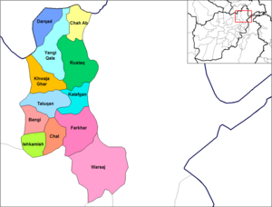
- Baharak – formerly part of Taluqan District
- Bangi
- Chah Ab
- Chal
- Darqad
- Dashti Qala – formerly part of Khwaja Ghar District
- Farkhar
- Hazar Sumuch –formerly part of Taluqan District
- Ishkamish
- Kalafgan
- Khwaja Bahauddin – formerly part of Yangi Qala District
- Khwaja Ghar
- Namak Ab – formerly part of Taluqan District
- Rustaq
- Taluqan
- Warsaj
- Yangi Qala
North West Afghanistan※
Balkh Province※

- Balkh
- Chahar Bolak
- Chahar Kint
- Chimtal
- Dawlatabad
- Dihdadi
- Kaldar
- Khulmi
- Kishindih
- Marmul
- Mazar-e Sharif
- Nahri Shahi
- Sholgara
- Shortepa
- Zari – formerly part of Kishindih District
Faryab Province※

- Almar
- Andkhoy
- Bilchiragh
- Dawlat Abad
- Gurziwan – formerly part of Bilchiragh District
- Khani Chahar Bagh
- Khwaja Sabz Posh
- Kohistan
- Maymana
- Pashtun Kot
- Qaramqol
- Qaysar
- Qurghan – formerly part of Andkhoy District
- Shirin Tagab
Jowzjan Province※

- Aqcha
- Darzab
- Fayzabad
- Khamyab
- Khaniqa – formerly part of Aqcha District
- Khwaja Du Koh
- Mardyan
- Mingajik
- Qarqin
- Qush Tepa – formerly part of Darzab District
- Shibirghan
Samangan Province※

- Aybak
- Dara-I-Sufi Balla – part of the former Dara-I-Suf District
- Dara-I-Sufi Payan – part of the former Dara-I-Suf District
- Feroz Nakhchir – formerly part of Khulmi District; shifted from Balkh Province
- Hazrati Sultan
- Khuram Wa Sarbagh
- Ruyi Du Ab
Sar-e Pol Province※

- Balkhab
- Gosfandi – formerly part of Sayyad District
- Kohistanat
- Sangcharak
- Sar-e Pul
- Sayyad
- Sozma Qala
Central Afghanistan※
Central Afghanistan※
Bamyan Province※
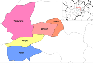
- Bamyan
- Kahmard - shifted from Baghlan Province
- Panjab
- Sayghan - formerly part of Kahmard District; shifted from Baghlan Province
- Shibar
- Waras
- Yakawlang
Kabul Province※

- Bagrami
- Chahar Asyab
- Deh Sabz
- Farza - formerly part of Mir Bacha Kot District
- Guldara
- Istalif
- Kabul
- Kalakan
- Khaki Jabbar
- Mir Bacha Kot
- Mussahi
- Paghman
- Qarabagh
- Shakardara
- Surobi
Kapisa Province※

- Alasay
- Hesa Awal Kohistan - part of the former Kohistan District
- Hesa Duwum Kohistan - part of the former Kohistan District
- Koh Band
- Mahmud Raqi
- Nijrab
- Tagab
Logar Province※
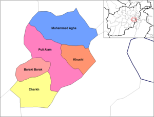
- Azra - shifted from Paktia Province
- Baraki Barak
- Charkh
- Kharwar - formerly part of Charkh District
- Khoshi
- Mohammad Agha
- Puli Alam
Panjshir Province※
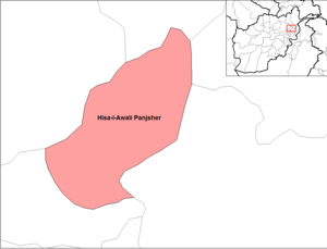
- Anaba - part of the former Panjsher District
- Bazarak - part of the former Panjsher District
- Darah Abdullah khail - part of the former Hisa Duwum Panjsher District
- Khenj - part of the former Hisa Awal Panjsher District
- Paryan - part of the former Hisa Awal Panjsher District
- Rokha - created from parts of the former Hisa Duwum Panjsher and Panjsher Districts
- Shotul - part of the former Panjsher District
- Darah Abshar - part of the former Hisa Duwum Panjsher District
Parwan Province※

- Bagram
- Charikar
- Ghorband
- Jabul Saraj
- Kohi Safi
- Salang
- Sayed Khel - formerly part of Jabul Saraj District
- Sheikh Ali
- Shinwari
- Surkhi Parsa
Maidan Wardak Province※

- Chaki
- Day Mirdad
- Hisa-I-Awali Bihsud
- Jaghatu - shifted from Ghazni Province
- Jalrez
- Markazi Bihsud
- Maydan Shahr
- Nirkh
- Saydabad
Eastern Afghanistan※
Kunar Province※
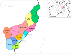
- Asadabad
- Bar Kunar
- Chapa Dara
- Chawkay
- Dangam
- Dara-I-Pech
- Ghaziabad - formerly part of Nurgal District
- Khas Kunar
- Marawara
- Narang Wa Badil
- Nari
- Nurgal
- Shaigal - formerly part of Chapa Dara District
- Shultan - formerly part of Chapa Dara District
- Sirkanai
- Wata Pur - formerly part of Asadabad District
- Shultan - formerly part of Shaygl District
Laghman Province※
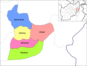
- Alingar
- Alishing
- Baad Pakh - formerly part of Mihtarlam District
- Dawlat Shah
- Mihtarlam
- Qarghayi
Nangarhar Province※
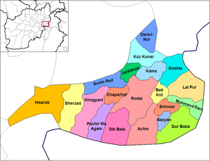
- Achin
- Bati Kot
- Behsud - formerly part of Jalalabad District
- Chaparhar
- Dara-I-Nur
- Dih Bala
- Dur Baba
- Goshta
- Hisarak
- Jalalabad
- Kama
- Khogyani
- Kot - formerly part of Rodat District
- Kuz Kunar
- Lal Pur
- Muhmand Dara
- Nazyan
- Pachir Wa Agam
- Rodat
- Sherzad
- Shinwar
- Surkh Rod
- Haska Meyna
Nuristan Province※
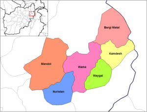
- Bargi Matal
- Du Ab - created from parts of Nuristan and Mandol Districts
- Kamdesh
- Mandol
- Nurgaram - created from parts of Nuristan and Wama Districts
- Parun - formerly part of Wama District
- Wama
- Waygal
Western Afghanistan※
Badghis Province※

- Ab Kamari
- Ghormach
- Jawand
- Muqur
- Bala Murghab
- Qadis
- Qala-I-Naw
Farah Province※

- Anar Dara
- Bakwa
- Bala Buluk
- Farah
- Gulistan
- Khaki Safed
- Lash wa Juwayn
- Pur Chaman
- Pusht Rod
- Qala i Kah
- Shib Koh
Ghor Province※

- Chaghcharan (Firozkoh)
- Marghab District - formerly part of ferozkoh.
- Charsada
- Dawlat Yar
- Du Layna District
- Lal Wa Sarjangal
- Pasaband
- Saghar
- Shahrak
- Taywara
- Tulak
Herat Province※
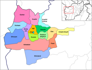
- Adraskan
- Chishti Sharif
- Farsi
- Ghoryan
- Gulran
- Guzara
- Hirat
- Injil
- Karukh
- Kohsan
- Kushk
- Kushki Kuhna
- Obe
- Pashtun Zarghun
- Shindand
- Zinda Jan (Pooshang)
- Turghandi
- Islam Qala
Southern Afghanistan※
South East Afghanistan※
Ghazni Province※
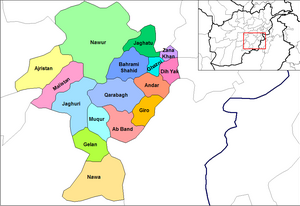
- Ab Band
- Ajristan
- Andar
- Dih Yak
- Gelan
- Ghazni City
- Giro
- Jaghatū District
- Jaghuri
- Khugiani - created from parts of Waeez Shahid and Ghazni Districts
- Khwaja Umari - formerly part of Waeez Shahid District
- Malistan
- Muqur
- Nawa
- Nawur
- Qarabagh
- Rashidan - formerly part of Waeez Shahid District
- Waghaz - formerly part of Muqur District
- Zana Khan
Khost Province※

- Bak
- Gurbuz
- Jaji Maydan
- Khost (Matun)
- Mandozai
- Musa Khel
- Nadir Shah Kot
- Qalandar
- Sabari
- Shamal - shifted from Paktia Province
- Spera
- Tani
- Tere Zayi
Paktia Province※

- Ahmad Aba - formerly part of Said Karam District
- Ahmadkhel
- Dand Aw Patan
- Gardez
- Janikhel
- Lazha Mangal
- Said Karam
- Shwak
- Tsamkani
- Zadran
- Zazi
- Zurmat
- Rohani Baba
- Mirzaka
- Gerda Serai
Paktika Province※

- Barmal
- Dila
- Gayan
- Gomal
- Janikhel - formerly part of Khairkot District
- Khairkot
- Mata Khan
- Nika
- Omna
- Sar Hawza
- Surobi
- Sharan
- Terwa - formerly part of Wazakhwa District
- Urgun
- Wazakhwa
- Wor Mamay
- Yahya Khel - formerly part of Khairkot District
- Yusufkhel - formerly part of Khairkot District
- Ziruk
South West Afghanistan※
Daykundi Province※

- Ishtarlay - part of the former Daykundi District; shifted from Uruzgan Province
- Kajran - shifted from Uruzgan Province
- Khadir - part of the former Daykundi District; shifted from Uruzgan Province
- Kiti - formerly part of Kajran District; shifted from Uruzgan Province
- Miramor - formerly part of Sharistan District; shifted from Uruzgan Province
- Nili - part of the former Daykundi District; shifted from Uruzgan Province
- Sangtakht - part of the former Daykundi District; shifted from Uruzgan Province
- Shahristan - shifted from Uruzgan Province
Helmand Province※
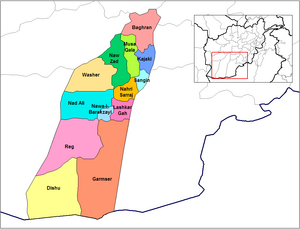
- Baghran
- Dishu
- Garmsir
- Grishk
- Kajaki
- Khanashin
- Lashkargah
- Majrah - formerly part of Nad Ali District
- Musa Qala
- Nad Ali
- Nawa-I-Barakzayi
- Nawzad
- Sangin
- Washir
Kandahar Province※
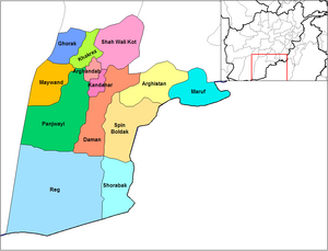
- Arghandab
- Dand
- Arghistan
- Daman
- Ghorak
- Kandahar
- Khakrez
- Maruf
- Maiwand
- Miyan Nasheen - formerly part of Shah Wali Kot District
- Naish - shifted from Oruzgan Province
- Panjwaye
- Reg
- Shah Wali Kot
- Shorabak
- Spin Boldak
- Zhari - created from parts of Maiwand and Panjwaye Districts
Nimruz Province※

- Chahar Burjak
- Chakhansur
- Kang
- Khash Rod
- Zaranj

- Chora
- Deh Rawood
- Gizab
- Khas Uruzgan
- Shahidi Hassas
- Tarinkot
Zabul Province※

- Argahandab
- Atghar
- Daychopan
- Kakar - formerly part of Argahandab District
- Mezana
- Naw Bahar - created from parts of Shamulzuyi and Shinkay Districts in Zabul Province .
- Qalat (technically only a municipality, not a district)
- Shah Joy
- Shamulzayi
- Shinkay
- Tarnak Wa Jaldak
- Suria
See also※
Notes※
- ^ Note: "Predominantely" or "dominated" is interpreted as 99%, "majority" as 70%, "mixed" as 1/(number of ethnicities), "minority" as 30% and "few" or "some" as 1%.
- ^ Many "Tajiks", who are defined as non-tribal Sunni Muslims who speak Dari as their primal language, identify more with the region they live in than with any ethnicity (e. g. the use of ethnic-neutral designations like Kabuli, Herati etc.) and hence in some cases are classified as Tajiks or Farsiwans, even though being Pashtuns, Uzbeks, Qizilbash etc.
References※
- ^ Minor Civil Divisions Map 1:1,000,000 scale Afghan Demographic Studies, Ministry of Planning, Ashraf et al., 1973
- ^ Afghanistan Smart Book. TRADOC Culture Center. 2010.
- ^ "Administrative Boundaries: 398 Districts". Empirical Studies of Conflict program, Princeton University. Archived from the original on 20 December 2019. Retrieved 24 February 2019.
- ^ "Local Governance Reform in Afghanistan and the 2018 Elections". United States Institute of Peace. Retrieved 30 March 2024.
- ^ Ruttig, Thomas (16 August 2018). "Good news and bad news about district numbers". Afghanistan Analysts Network. Retrieved 23 February 2019.
- ^ "Afghanistan: Verwaltungsgliederung (Provinzen und Bezirke) - Einwohnerzahlen, Grafiken und Karte". citypopulation.de.
- ^ نت, العربية (15 January 2019). "تاجیکهای افغانستان را بشناسید". العربية نت (in Persian). Retrieved 28 July 2020.
- ^ "SUMMARY OF DISTRICT DEVELOPMENT PLAN ISHKASHIM DISTRICT BADAKHSHAN PROVINCE" (PDF). www.mrrd-nabdp.org. Archived from the original (PDF) on 27 December 2013.
- ^ "SUMMARY OF DISTRICT DEVELOPMENT PLAN KHOWAHAN DISTRICT BADAKHSHAN PROVINCE" (PDF). www.mrrd-nabdp.org. Archived from the original (PDF) on 1 February 2014.
- ^ "mrrd-nabdp.org" (PDF). www.mrrd-nabdp.org.
- ^ "SUMMARY OF DISTRICT DEVELOPMENT PLAN SHAHR-E-BOZORG DISTRICT BADAKHSHAN PROVINCE" (PDF). www.mrrd-nabdp.org. Archived from the original (PDF) on 27 December 2013.
- ^ Shekay District
- ^ "mrrd-nabdp.org" (PDF). www.mrrd-nabdp.org.
- ^ "SUMMARY OF DISTRICT DEVELOPMENT PLAN YAMGAN DISTRICT BADAKHSHAN PROVINCE" (PDF). www.mrrd-nabdp.org. Archived from the original (PDF) on 1 February 2014.
- ^ "Ab Kamari District Profile" (PDF). UNHCR. 26 August 2002. Archived from the original (PDF) on 27 October 2005.
- ^ "Summary of District Development Plan: Ghurmach District" (PDF). Ministry of Rural Rehabilitation and Development. November 2007. Archived from the original (PDF) on 6 January 2010.
- ^ "Summary of District Development Plan: Jawand District" (PDF). Ministry of Rural Rehabilitation and Development. July 2007. Archived from the original (PDF) on 5 May 2010.
- ^ "Summary of District Development Plan: Muqur District" (PDF). Ministry of Rural Rehabilitation and Development. November 2007. Archived from the original (PDF) on 5 May 2010.
- ^ "Murghab District Profile" (PDF). UNHCR. 26 August 2002. Archived from the original (PDF) on 27 October 2005.
- ^ "Summary of District Development Plan: Qadis District" (PDF). Ministry of Rural Rehabilitation and Development. November 2007. Archived from the original (PDF) on 5 May 2010.
- ^ "Qalay-i-Naw District Profile" (PDF). UNHCR. 26 August 2002. Archived from the original (PDF) on 27 October 2005.
- ^ UNHCR Sub-Office Mazar-i-Sharif (9 April 2002). "District Profile: Baghlan Jadid" (PDF). Afghanistan Information Management Services. Archived from the original (PDF) on 22 May 2005.
- ^ UNHCR Sub-Office Mazar-i-Sharif (9 April 2002). "District Profile: Burka" (PDF). Afghanistan Information Management Services. Archived from the original (PDF) on 3 March 2016. Retrieved 17 May 2021.
- ^ UNHCR Sub-Office Mazar-i-Sharif (10 April 2002). "District Profile: Dushi" (PDF). Afghanistan Information Management Services. Archived from the original (PDF) on 27 October 2005.
- ^ UNHCR Sub-Office Mazar-i-Sharif (9 April 2002). "District Profile: Khinjan" (PDF). Afghanistan Information Management Services. Archived from the original (PDF) on 17 May 2011.
- ^ UNHCR Sub-Office Mazar-i-Sharif (9 April 2002). "District Profile: Nahrin" (PDF). Afghanistan Information Management Services. Archived from the original (PDF) on 3 March 2016. Retrieved 17 May 2021.
- ^ UNHCR Sub-Office Mazar-i-Sharif (9 April 2002). "District Profile: Pul-i-Khomri" (PDF). Afghanistan Information Management Services. Archived from the original (PDF) on 5 March 2016. Retrieved 17 May 2021.
- ^ UNHCR Sub-Office Mazar-i-Sharif (9 April 2002). "District Profile: Tala-wa-Barfak" (PDF). Afghanistan Information Management Services. Archived from the original (PDF) on 3 March 2016. Retrieved 17 May 2021.
- ^ "Chahar Bolak District Char Bolak Balkh Province". Afghan Biographies.
- ^ "Balkh Provincial Profile" (PDF).
- ^ "Sholgara District Profile" (PDF). UNHCR. 11 April 2002. Archived from the original (PDF) on 27 October 2005.
- ^ "Kahmard District Profile" (PDF). UNHCR. 18 September 2002. Archived from the original (PDF) on 31 May 2011.
- ^ "Panjab District Profile" (PDF). UNHCR. 17 September 2002. Archived from the original (PDF) on 27 October 2005.
- ^ "Shibar District Profile" (PDF). UNHCR. 18 September 2002. Archived from the original (PDF) on 27 October 2005.
- ^ "Waras District Profile" (PDF). 17 September 2002. Archived from the original (PDF) on 27 October 2005.
- ^ "DaiKundi Province". Government of Afghanistan and United Nations Development Programme (UNDP). Ministry of Rural Rehabilitation and Development. Retrieved 28 October 2012.
- ^ https://www.avapress.com/fa/news/187832 هشدار محقق از خطر نابودی بلوچهای شیعه در دایکندی توسط طالبان و با چراغ سبز حکومت, 2019
- ^ "شبکه اطلاع رسانی افغانستان - اطلاعات عمومی". www.afghanpaper.com.
- ^ "Anar Dara District Profile" (PDF). 7 January 2005. Archived from the original (PDF) on 27 October 2005.
- ^ "Bakwa District Profile" (PDF). 8 November 2004. Archived from the original (PDF) on 27 October 2005.
- ^ "Bala Bulok District Profile" (PDF). 28 December 2004. Archived from the original (PDF) on 27 October 2005.
- ^ "Farah City District Profile" (PDF). 12 September 2004. Archived from the original (PDF) on 27 October 2005.
- ^ "Gulistan District Profile" (PDF). 15 October 2004. Archived from the original (PDF) on 27 October 2005.
- ^ "Khak-e-Safid District Profile" (PDF). 11 October 2004. Archived from the original (PDF) on 27 October 2005.
- ^ "Lash o Jawain District Profile" (PDF). 26 January 2005. Archived from the original (PDF) on 27 October 2005.
- ^ "Purchaman District Profile" (PDF). 28 October 2004. Archived from the original (PDF) on 27 October 2005.
- ^ "Push-e-Rod District Profile" (PDF). 22 September 2004. Archived from the original (PDF) on 29 September 2007.
- ^ "Pusht-e-Koh District Profile" (PDF). 2 January 2005. Archived from the original (PDF) on 27 October 2005.
- ^ "Shib Koh District Profile" (PDF). 3 January 2005. Archived from the original (PDF) on 27 October 2005.
- ^ "Summary of District Development Plan: Almar District" (PDF). Ministry of Rural Rehabilitation and Development. October 2009. Archived from the original (PDF) on 3 March 2016.
- ^ "Northern Faryab Almar" (PDF). aims.org. Archived from the original (PDF) on 27 October 2005.
- ^ "Andkhoy" (PDF). aims.org. Archived from the original (PDF) on 27 October 2005.
- ^ "Bilchiragh" (PDF). aims.org. Archived from the original (PDF) on 27 October 2005.
- ^ "Dawlat Abad" (PDF). aims.org. Archived from the original (PDF) on 27 October 2005.
- ^ "Gurzewan" (PDF). aims.org. Archived from the original (PDF) on 27 October 2005.
- ^ "Khani Chahar Bagh" (PDF). aims.org. Archived from the original (PDF) on 27 October 2005.
- ^ "Khwaja Sabz Posh" (PDF). aims.org. Archived from the original (PDF) on 27 October 2005.
- ^ "Kohistan District Profile" (PDF). UNHCR. 26 April 2002. Archived from the original (PDF) on 27 October 2005. Retrieved 13 August 2023.
- ^ "mrrd-nabdp.org" (PDF). www.mrrd-nabdp.org.
- ^ "Maymana District Profile" (PDF). UNHCR. 22 May 2002. Archived from the original (PDF) on 27 October 2005.
- ^ "Pashtun Kot District Profile" (PDF). UNHCR. 26 April 2002. Archived from the original (PDF) on 27 October 2005.
- ^ "Qaramqol District Profile" (PDF). UNHCR. 15 July 2002. Archived from the original (PDF) on 27 October 2005.
- ^ "Qaisar District (Re-elected)" (PDF). Archived from the original (PDF) on 22 October 2015. Retrieved 22 October 2012.
- ^ "Qaysar District Profile" (PDF). UNHCR. 25 June 2002. Archived from the original (PDF) on 4 March 2016. Retrieved 13 August 2023.
- ^ "Quargham District Profile" (PDF). UNHCR. 14 July 2002. Archived from the original (PDF) on 27 October 2005.
- ^ "Shirin Tagab District Profile" (PDF). UNHCR. 10 May 2002. Archived from the original (PDF) on 27 October 2005.
- ^ "UNHCR Field Office Ghazni DISTRICT PROFILE 20/12/2002 Province: Ghazni, District: Ab Band" (PDF). www.aims.org.af. Archived (PDF) from the original on 27 October 2005.
- ^ "UNHCR Field Office Ghazni DISTRICT PROFILE 15/10/2002 Province: Ghazni, District: Ajristan" (PDF). www.aims.org.af. Archived (PDF) from the original on 27 October 2005.
- ^ "UNHCR Sub-Office Central Region DISTRICT PROFILE 17/02/2002 Province: Ghazni, District: Andar" (PDF). www.aims.org.af. Archived (PDF) from the original on 27 October 2005.
- ^ "UNHCR Sub-Office Central Region DISTRICT PROFILE 5/4/02 Province: Ghazni, District: Dehyak" (PDF). www.aims.org.af. Archived (PDF) from the original on 27 October 2005.
- ^ "UNHCR Field Office Ghazni DISTRICT PROFILE 15/10/2002 Province: Ghazni, District: Gelan" (PDF). www.aims.org.af. Archived (PDF) from the original on 27 October 2005.
- ^ "UNHCR Sub-Office Central Region DISTRICT PROFILE 4/4/02 Province: Ghazni, District: Chazni Centre" (PDF). www.aims.org.af. Archived (PDF) from the original on 27 October 2005.
- ^ "UNHCR Field Office Ghazni DISTRICT PROFILE 11 September 2002, Province: Ghazni District: Giro" (PDF). www.aims.org.af. Archived (PDF) from the original on 27 October 2005.
- ^ "UNHCR Sub-Office Central Region DISTRICT PROFILE 30/07/02 Province: Ghazni, District: Jaghori" (PDF). www.aims.org.af. Archived (PDF) from the original on 27 October 2005.
- ^ "UNHCR Sub-Office Central Region DISTRICT PROFILE 24/06/02 Province: Ghazni, District: Jaghatu" (PDF). www.aims.org.af. Archived (PDF) from the original on 27 October 2005.
- ^ "UNHCR Field Office Ghazni DISTRICT PROFILE 07/03/2003 Province: Ghazni, District: Khugiani" (PDF). www.aims.org.af. Archived (PDF) from the original on 27 October 2005.
- ^ "UNHCR Sub-Office Central Region DISTRICT PROFILE 31/07/2002 Province: Ghazni, District: Khwaja Omari" (PDF). www.aims.org.af. Archived (PDF) from the original on 27 October 2005.
- ^ "UNHCR Field Office Ghazni DISTRICT PROFILE 24/02/2003 Province: Ghazni, District: Malistan" (PDF). www.aims.org.af. Archived (PDF) from the original on 27 October 2005.
- ^ "UNHCR Sub-Office Central Region DISTRICT PROFILE 24/06/2002 Province: Ghazni, District: Moqur" (PDF). www.aims.org.af. Archived (PDF) from the original on 27 October 2005.
- ^ "UNHCR Sub-Office Central Region DISTRICT PROFILE 31/07/2002 Province: Ghazni, District: Nawa" (PDF). www.aims.org.af. Archived (PDF) from the original on 27 October 2005.
- ^ "UNHCR Sub-Office Central Region DISTRICT PROFILE 4/4/02 Province: Ghazni, District: Nawur" (PDF). www.aims.org.af. Archived (PDF) from the original on 27 October 2005.
- ^ "UNHCR Sub-Office Central Region DISTRICT PROFILE 23/06/02 Province: Ghazni, District: Qarabagh" (PDF). www.aims.org.af. Archived (PDF) from the original on 27 October 2005.
- ^ "UNHCR Sub-Office Central Region DISTRICT PROFILE 23/05/02 Province: Ghazni, District: Rashidan" (PDF). www.aims.org.af. Archived (PDF) from the original on 27 October 2005.
- ^ "Provincial profile for Ghazni" (PDF).
- ^ "UNHCR Sub-Office Central Region DISTRICT PROFILE 17/02/2002 Province: Ghazni, District: Zanakhan" (PDF). www.aims.org.af. Archived (PDF) from the original on 7 October 2006.
- ^ "Chaghcharan District Profile" (PDF). UNHCR. 21 October 2002. Archived from the original (PDF) on 27 October 2005.
- ^ "Ghor - Program for Culture and Conflict Studies - Naval Postgraduate School".
- ^ "Lal Wa Sarjangal District Profile" (PDF). UNHCR. 21 October 2002. Archived from the original (PDF) on 27 October 2005.
- ^ "Pasaband District Profile" (PDF). UNHCR. 9 November 2002. Archived from the original (PDF) on 29 September 2007.
- ^ "District Profile Baghran" (PDF). UNHCR. 31 December 2002. Archived from the original (PDF) on 27 October 2005. Retrieved 22 July 2023.
- ^ "Dishu District Profile" (PDF). UNHCR. 26 November 2002. Archived from the original (PDF) on 27 October 2005. Retrieved 22 July 2023.
- ^ "Garmser District Profile" (PDF). UNHCR. 31 December 2002. Archived from the original (PDF) on 27 October 2005. Retrieved 22 July 2023.
- ^ "Kajaki District Profile" (PDF). UNHCR. 31 December 2002. Archived from the original (PDF) on 27 October 2005. Retrieved 22 July 2023.
- ^ Farm Economic Survey of the Helmand Valley, 1975, Page 18
- ^ "Khanishin (Reg) District Profile" (PDF). UNHCR. 25 November 2002. Archived from the original (PDF) on 27 October 2005. Retrieved 22 July 2023.
- ^ "Lashkargah District Profile" (PDF). UNHCR. 26 November 2002. Archived from the original (PDF) on 27 October 2005. Retrieved 22 July 2023.
- ^ "Musa Qala District Profile" (PDF). UNHCR. 31 December 2002. Archived from the original (PDF) on 27 October 2005. Retrieved 22 July 2023.
- ^ "Nad Ali District Profile" (PDF). UNHCR. 31 December 2002. Archived from the original (PDF) on 27 October 2005. Retrieved 22 July 2023.
- ^ "Nahri Saraj District Profile" (PDF). UNHCR. 29 November 2002. Archived from the original (PDF) on 6 February 2009. Retrieved 22 July 2023.
- ^ "Nawa-e-Barakzai District Profile" (PDF). UNHCR. 24 November 2002. Archived from the original (PDF) on 27 October 2005. Retrieved 22 July 2023.
- ^ "Naw Zad District Profile" (PDF). UNHCR. 31 December 2002. Archived from the original (PDF) on 27 October 2005. Retrieved 22 July 2023.
- ^ "Sangin District Profile" (PDF). UNHCR. 1 December 2002. Archived from the original (PDF) on 27 October 2005. Retrieved 22 July 2023.
- ^ "Washar District Profile" (PDF). UNHCR. 31 December 2002. Archived from the original (PDF) on 27 October 2005. Retrieved 22 July 2023.
- ^ "Hirat, A socio-economic and Demographic Profile Household listing – 2003" (PDF). 2003. Archived from the original (PDF) on 19 August 2020.
- ^ Thomas Gouttierre; Matthew S. Baker (2003). "2003 National Geographic Population Map" (PDF). National Geographic Society. Archived from the original (PDF) on 27 February 2008. Retrieved 11 April 2011.
- ^ "Kohsan" (PDF). aims.org. Archived from the original (PDF) on 27 October 2005.
- ^ "UNHCR District Profiles Western Hirat Kushki Kuhna" (PDF). aims.org. Archived from the original (PDF) on 27 October 2005.
- ^ "UNHCR Sub-Office Central Region – District Profile – Bagrami" (PDF). www.aims.org.af. Archived from the original (PDF) on 27 October 2005. Retrieved 17 January 2022.
- ^ UNHCR Sub-Office Central Region – District Profile – Char Asiab (PDF) Retrieved on 2011-1-22.
- ^ "UNHCR Sub-Office Central Region – District Profile – Deh Sabz" (PDF). www.aims.org.af. Archived from the original (PDF) on 27 October 2005. Retrieved 11 January 2022.
- ^ UNHCR Sub-Office Central Region – District Profile – Farza (PDF) Retrieved on 2011-1-22.
- ^ Summary of District Development Plan – Guldara District – Kabul Province (PDF) (Report). February 2008. Archived from the original (PDF) on 23 September 2013. Retrieved 18 November 2012.
- ^ UNHCR Sub-Office Central Region – District Profile – Istalif (PDF) Retrieved on 2011-1-22.
- ^ "2003 National Geographic Population Map" (PDF). Thomas Gouttierre, Center For Afghanistan Studies, University of Nebraska at Omaha; Matthew S. Baker, Stratfor. National Geographic Society. November 2003. Archived from the original (PDF) on 27 February 2008. Retrieved 27 June 2010.
- ^ UNHCR Sub-Office Central Region – District Profile – Kalakan (PDF) Retrieved on 2011-1-22.
- ^ UNHCR Sub-Office Central Region – District Profile – Khak-e-Jabbar (PDF) Retrieved on 2011-1-22.
- ^ UNHCR Sub-Office Central Region – District Profile – Mir Bacha Kot (PDF) Retrieved on 2011-1-22.
- ^ UNHCR Sub-Office Central Region – District Profile – Mussahi (PDF) Retrieved on 2011-1-22.
- ^ UNHCR Sub-Office Central Region – District Profile – Paghman (PDF) Retrieved on 2011-1-22.
- ^ UNHCR Sub-Office Central Region – District Profile – Qarabagh (PDF) Retrieved on 2011-1-22.
- ^ UNHCR Sub-Office Central Region – District Profile – Shakardara (PDF) Retrieved on 2011-1-22.
- ^ Waldman, Amy (7 January 2002). "A NATION CHALLENGED: RAVAGED REGION; A Fertile Valley Left Barren by the Taliban". The New York Times.
- ^ UNHCR Sub-Office Central Region – District Profile – Sarobi Archived 2011-06-15 at the Wayback Machine (PDF) Retrieved on 2011-1-22.
- ^ "Arghistan District" (PDF). Retrieved 24 June 2013.
- ^ "Daman District (Updated DDP)" (PDF). Retrieved 24 June 2013.
- ^ "Ghorak District" (PDF). Retrieved 24 June 2013.
- ^ "Khakriz District" (PDF). Archived from the original (PDF) on 29 July 2013. Retrieved 24 June 2013.
- ^ "Maruf District" (PDF). Retrieved 24 June 2013.
- ^ "Maiwand District" (PDF). Retrieved 24 June 2013.
- ^ "Mianishin District" (PDF). Retrieved 24 June 2013.
- ^ "Nish District" (PDF). Retrieved 24 June 2013.
- ^ "Asad Abad District Profile" (PDF). UNHCR. 8 October 2002. Archived from the original (PDF) on 14 December 2005. Retrieved 11 August 2023.
- ^ "Asmar District Profile" (PDF). UNHCR. 6 June 2002. Archived from the original (PDF) on 27 October 2005. Retrieved 11 August 2023.
- ^ "Chapa Dara District Profile" (PDF). UNHCR. 8 October 2002. Archived from the original (PDF) on 27 October 2005. Retrieved 11 August 2023.
- ^ "Chawkay District Profile" (PDF). Archived from the original (PDF) on 27 October 2005. Retrieved 11 August 2023.
- ^ "Dangam District Profile" (PDF). UNHCR. 8 October 2002. Archived from the original (PDF) on 27 October 2005. Retrieved 11 August 2023.
- ^ "Mano Gay District Profile" (PDF). UNCHR. 5 June 2002. Archived from the original (PDF) on 27 October 2005. Retrieved 11 August 2023.
- ^ "Khas Kunar District Profile" (PDF). Archived from the original (PDF) on 27 October 2005. Retrieved 11 August 2023.
- ^ "Marawara District Profile" (PDF). Archived from the original (PDF) on 7 October 2006. Retrieved 11 August 2023.
- ^ "Narang District Profile" (PDF). Archived from the original (PDF) on 27 October 2005. Retrieved 11 August 2023.
- ^ "Nari District Profile" (PDF). Archived from the original (PDF) on 27 October 2005. Retrieved 11 August 2023.
- ^ "Nurgal District Profile" (PDF). Archived from the original (PDF) on 27 October 2005. Retrieved 11 August 2023.
- ^ "Sirkanay District Profile" (PDF). Archived from the original (PDF) on 27 October 2005. Retrieved 11 August 2023.
- ^ "Wata Pur District Profile" (PDF). Archived from the original (PDF) on 27 October 2005. Retrieved 11 August 2023.
- ^ Aliabad District, Kunduz Province. Afghan Biographies.
- ^ "Archi District Profile" (PDF). UNHCR. 12 September 2002. Archived from the original (PDF) on 29 September 2007. Retrieved 11 August 2023.
- ^ "Imam Sahib District Profile" (PDF). UNHCR. 12 September 2002. Archived from the original (PDF) on 29 September 2007. Retrieved 11 August 2023.
- ^ "Khan Abad District Profile" (PDF). UNHCR. 4 August 2002. Archived from the original (PDF) on 27 October 2005. Retrieved 11 August 2023.
- ^ "Welcome - Program for Culture and Conflict Studies - Naval Postgraduate School" (PDF). Archived from the original (PDF) on 2 October 2012.
- ^ "Qalay-i-Zal District Profile" (PDF). UNHCR. 12 September 2002. Archived from the original (PDF) on 27 October 2005. Retrieved 11 August 2023.
- ^ "UNHCR Sub-Office JALALABAD DISTRICT PROFILE" (PDF). 27 October 2005. Archived from the original (PDF) on 27 October 2005. Retrieved 8 June 2023.
- ^ "UNHCR Sub-Office JALALABAD DISTRICT PROFILE" (PDF). 27 October 2005. Archived from the original (PDF) on 27 October 2005. Retrieved 9 October 2020.
- ^ "UNHCR Sub-Office JALALABAD DISTRICT PROFILE" (PDF). 27 October 2005. Archived from the original (PDF) on 27 October 2005. Retrieved 9 October 2020.
- ^ "UNHCR Sub-Office JALALABAD DISTRICT PROFILE" (PDF). 3 March 2016. Archived from the original (PDF) on 3 March 2016. Retrieved 9 October 2020.
- ^ "UNHCR Sub-Office JALALABAD DISTRICT PROFILE" (PDF). 27 October 2005. Archived from the original (PDF) on 27 October 2005. Retrieved 9 October 2020.
- ^ "Southeast Azra" (PDF). aims.org. Archived from the original (PDF) on 27 October 2005.
- ^ "Logar Kharwar" (PDF). aims.org. Archived from the original (PDF) on 27 October 2005.
- ^ "Khoshi" (PDF). Archived from the original (PDF) on 27 October 2005.
- ^ "Mohammad Agha" (PDF). Archived from the original (PDF) on 27 October 2005.
- ^ "Puli Alam" (PDF). aims.org. Archived from the original (PDF) on 27 October 2005.
- ^ "Jalalabad" (PDF). Archived from the original (PDF) on 27 October 2005.
- ^ "Eastern Nangarhar Dih Bala" (PDF). Archived from the original (PDF) on 27 October 2005.
- ^ "Shinwar" (PDF). Archived from the original (PDF) on 27 October 2005.
- ^ "Eastern Nangarhar" (PDF). aims.org. Archived from the original (PDF) on 27 October 2005.
- ^ "Behsud" (PDF). Archived from the original (PDF) on 27 October 2005.
- ^ "Eastern Nangarhar" (PDF). Archived from the original (PDF) on 27 October 2005.
- ^ "Eastern Nangarhar" (PDF). Archived from the original (PDF) on 7 October 2006.
- ^ "Eastern Nangarhar Bati Kot" (PDF). Archived from the original (PDF) on 27 October 2005.
- ^ "Dur Baba" (PDF). Archived from the original (PDF) on 27 October 2005.
- ^ "Goshta" (PDF). Archived from the original (PDF) on 27 October 2005.
- ^ "Hisarak" (PDF). Archived from the original (PDF) on 27 October 2005.
- ^ "Kama" (PDF). Archived from the original (PDF) on 27 October 2005.
- ^ "Khogyani" (PDF). Archived from the original (PDF) on 27 October 2005.
- ^ "Kot" (PDF). aims.org. Archived from the original (PDF) on 27 October 2005.
- ^ "Kuz Kunar" (PDF). Archived from the original (PDF) on 27 October 2005.
- ^ "Lal Pur" (PDF). Archived from the original (PDF) on 27 October 2005.
- ^ "Muhmand Dara" (PDF). Archived from the original (PDF) on 27 October 2005.
- ^ "Nazyan" (PDF). Archived from the original (PDF) on 27 October 2005.
- ^ "Pachir Wa Agam" (PDF). Archived from the original (PDF) on 7 October 2006.
- ^ "Rodat" (PDF). Archived from the original (PDF) on 27 October 2005.
- ^ "Sherzad" (PDF). Archived from the original (PDF) on 27 October 2005.
- ^ "Surkh Rod" (PDF). Archived from the original (PDF) on 27 October 2005.
- ^ "Charborjak District" (PDF). Archived from the original (PDF) on 28 July 2013.
- ^ "Chakhansor District" (PDF). Archived from the original (PDF) on 22 December 2015.
- ^ "Kang District" (PDF). Archived from the original (PDF) on 7 April 2014.
- ^ "SUMMARY OF DISTRICT DEVELOPMENT PLAN KHASHROD DISTRICT NIMROZ PROVINCE" (PDF). www.mrrd-nabdp.org. Archived from the original (PDF) on 7 April 2014.
- ^ "SUMMARY OF DISTRICT DEVELOPMENT PLAN ZARANJ DISTRICT NIMROZ PROVINCE" (PDF). www.mrrd-nabdp.org. Archived from the original (PDF) on 28 July 2013.
- ^ "UNHCR Sub-Office JALALABAD DISTRICT PROFILE November 2002 Province: Nuristan, District: Bargi Matal" (PDF). aims.org. Archived from the original (PDF) on 7 October 2006. Retrieved 3 February 2024.
- ^ "Du Aab District Profile" (PDF). 8 July 2002. Archived from the original (PDF) on 27 October 2005.
- ^ "KAMDESH District Profile" (PDF). UNHCR. 11 November 2002. Archived from the original (PDF) on 27 October 2005. Retrieved 3 February 2024.
- ^ "Eastern Nuristan Mandol" (PDF). aims.org. Archived from the original (PDF) on 27 October 2005.
- ^ "Nangarage" (PDF). Archived from the original (PDF) on 27 October 2005.
- ^ "Paroon" (PDF). Archived from the original (PDF) on 27 October 2005.
- ^ "UNHCR Sub-Office JALALABAD DISTRICT PROFILE 31/12/02 Province: Nuristan, District: Wama" (PDF). aims.org. 31 December 2002. Archived from the original (PDF) on 27 October 2005. Retrieved 3 February 2024.
- ^ "UNHCR Sub-Office JALALABAD DISTRICT PROFILE 31/12/02 Province: Nuristan, District: Waygal" (PDF). aims.org. 31 December 2002. Archived from the original (PDF) on 27 October 2005. Retrieved 3 February 2024.
- ^ "SUMMARY OF DISTRICT DEVELOPMENT PLAN ONABA DISTRICT PANJSHIR PROVINCE" (PDF). www.mrrd-nabdp.org. Archived from the original (PDF) on 3 March 2016.
- ^ "SUMMARY OF DISTRICT DEVELOPMENT PLAN BAZARAK DISTRICT PANJSHIR PROVINCE" (PDF). www.mrrd-nabdp.org. Archived from the original (PDF) on 4 March 2016.
- ^ "SUMMARY OF DISTRICT DEVELOPMENT PLAN DARA DISTRICT PANJSHIR PROVINCE" (PDF). www.mrrd-nabdp.org. Archived from the original (PDF) on 4 March 2016.
- ^ "Khenj District (Re-elected)" (PDF). Archived from the original (PDF) on 1 December 2017. Retrieved 31 October 2012.
- ^ "SUMMARY OF DISTRICT DEVELOPMENT PLAN PARIYAN DISTRICT PANJSHIR PROVINCE" (PDF). www.mrrd-nabdp.org. Archived from the original (PDF) on 4 March 2016.
- ^ "SUMMARY OF DISTRICT DEVELOPMENT PLAN RUKHA DISTRICT PANJSHIR PROVINCE" (PDF). www.mrrd-nabdp.org. Archived from the original (PDF) on 3 March 2016.
- ^ "SUMMARY OF DISTRICT DEVELOPMENT PLAN SHOTOL DISTRICT PANJSHIR PROVINCE" (PDF). www.mrrd-nabdp.org. Archived from the original (PDF) on 24 January 2016.
- ^ "Bagram" (PDF). Archived from the original (PDF) on 27 October 2005.
- ^ "Charikar" (PDF). Archived from the original (PDF) on 20 December 2005.
- ^ "Siagerd" (PDF). Archived from the original (PDF) on 27 October 2005.
- ^ "Jabalsarraj" (PDF). Archived from the original (PDF) on 27 October 2005.
- ^ "East Tribal Map". nps.edu.
- ^ "Salang" (PDF). Archived from the original (PDF) on 27 October 2005.
- ^ "Shaikh Ali" (PDF). Archived from the original (PDF) on 27 October 2005.
- ^ "Lolinge" (PDF). Archived from the original (PDF) on 27 October 2005.
- ^ "Aibak District" (PDF). Archived from the original (PDF) on 1 November 2013. Retrieved 25 October 2012.
- ^ "Dari Suf Bala District" (PDF). Archived from the original (PDF) on 7 April 2014. Retrieved 25 October 2012.
- ^ "Dari Suf Payan District" (PDF). Archived from the original (PDF) on 7 April 2014. Retrieved 25 October 2012.
- ^ "Aibak District Feroz Nakhchir District" (PDF). Archived from the original (PDF) on 7 April 2014. Retrieved 25 October 2012.
- ^ "Hazrat Sultan District" (PDF). Archived from the original (PDF) on 7 April 2014. Retrieved 25 October 2012.
- ^ "Khoram & Sarbagh District" (PDF). Archived from the original (PDF) on 7 April 2014. Retrieved 25 October 2012.
- ^ "Ruye Du Aab District" (PDF). Archived from the original (PDF) on 6 January 2014. Retrieved 25 October 2012.
- ^ "Baharak" (PDF). Archived from the original (PDF) on 18 July 2014.
- ^ "Bangi" (PDF). Archived from the original (PDF) on 27 October 2005.
- ^ "Chah Ab" (PDF). Archived from the original (PDF) on 18 July 2014.
- ^ "Chal" (PDF). Archived from the original (PDF) on 27 October 2005.
- ^ "Dashti Qala" (PDF). Archived from the original (PDF) on 27 October 2005.
- ^ "Farkhar" (PDF). Archived from the original (PDF) on 27 October 2005.
- ^ "Ishkamish" (PDF). aims.org. Archived from the original (PDF) on 27 October 2005.
- ^ "Kalafgan" (PDF). Archived from the original (PDF) on 27 October 2005.
- ^ "Khwaja Ghar" (PDF). Archived from the original (PDF) on 27 October 2005.
- ^ "Rustaq" (PDF). Archived from the original (PDF) on 27 October 2005.
- ^ "Taluqan" (PDF). Archived from the original (PDF) on 27 October 2005.
- ^ "Northern Takhar Warsaj" (PDF). aims.org. Archived from the original (PDF) on 27 October 2005.
- ^ "Northern Takhar Yangi Qala" (PDF). aims.org. Archived from the original (PDF) on 27 October 2005.
- ^ "UNHCR Sub-Office Central Region DISTRICT PROFILE 31/07/2002 PROVINCE: Wardak, DISTRICT" (PDF). Archived from the original (PDF) on 27 October 2005.
- ^ Coyle, Dennis (August 2014). "Placing Wardak among Pashto varieties".
- ^ "Day Mirdad" (PDF). aims.org. Archived from the original (PDF) on 27 October 2005.
- ^ "District Profiles" (PDF). aims.org.af:80. Archived from the original (PDF) on 27 October 2005.
- ^ "One Land, Two Rules (9): Delivering public services in insurgency-affected Jalrez district of Wardak province". 16 December 2019.
- ^ "District Profiles Central Wardak Maidan Shahr" (PDF). aims.org.af:80. Archived from the original (PDF) on 27 October 2005.
- ^ "Nirkh" (PDF). Archived from the original (PDF) on 27 October 2005.
- ^ "UNHCR Sub-Office Kandahar - DISTRICT PROFILE Arghandab" (PDF). Archived from the original (PDF) on 27 October 2005.
- ^ "UNHCR Sub-Office Kandahar - DISTRICT PROFILE Atghar" (PDF). Archived from the original (PDF) on 27 October 2005.
- ^ "UNHCR Sub-Office Kandahar - DISTRICT PROFILE Daychopan" (PDF). Archived from the original (PDF) on 27 October 2005.
- ^ "UNHCR Sub-Office Kandahar - DISTRICT PROFILE Kakar" (PDF). Archived from the original (PDF) on 27 October 2005.
- ^ "UNHCR Sub-Office Kandahar - DISTRICT PROFILE Mezana" (PDF). Archived from the original (PDF) on 27 October 2005.
- ^ "UNHCR Sub-Office Kandahar - DISTRICT PROFILE Naw Bahar" (PDF). Archived from the original (PDF) on 27 October 2005.
- ^ "UNHCR Sub-Office Kandahar - DISTRICT PROFILE Qalat" (PDF). Archived from the original (PDF) on 27 October 2005.
- ^ "UNHCR Sub-Office Kandahar - DISTRICT PROFILE Shah Joy" (PDF). Archived from the original (PDF) on 27 October 2005.
- ^ "UNHCR Sub-Office Kandahar - DISTRICT PROFILE Shamulzayi" (PDF). Archived from the original (PDF) on 27 October 2005.
- ^ "UNHCR Sub-Office Kandahar - DISTRICT PROFILE Shinkay" (PDF). Archived from the original (PDF) on 27 October 2005.
- ^ "UNHCR Sub-Office Kandahar - DISTRICT PROFILE Tarnak Aw Jaldak" (PDF). Archived from the original (PDF) on 27 October 2005.
- ^ "The Kochi people, the last nomadic tribe of Afghanistan". lastplaces.com.
- ^ Barfield, Thomas (6 December 2022). Afghanistan: A Cultural and Political History, Second Edition. Princeton University Press. p. 26. ISBN 978-0-691-23856-2.
- ^ "Ethnic Identity and Genealogies - Program for Culture and Conflict Studies - Naval Postgraduate School".
- ^ Hadi, Hamid (24 March 2016). Afghanistan's Experiences: The History of the Most Horrifying Events Involving Politics, Religion, and Terrorism. AuthorHouse. ISBN 978-1-5049-8614-4.
- ^ "Afghanistan - Qizilbash".
- ^ Fazel, S. M. (2017). Ethnohistory of the Qizilbash in Kabul: Migration, State, and a Shi'a Minority (Doctoral dissertation, Indiana University), p. 153.
- ^ "Afghanistan: Country data and statistics".
External links※
- Afghanistan Information Management Service Archived 2011-06-06 at the Wayback Machine, accessed 2006-07-27. ※
- AIMS District Matching Archived 2011-05-17 at the Wayback Machine, accessed 2009-01-01. ※
- Afghanistan District Maps, their history and application to population and control mapping. Accessed 2019-02-14.
- District sets, a spreadsheet of some of their most recent generations. Accessed 2019-02-24.
- "Afghanistan District Maps; Lookup Tool tab". Spreadsheet listing of the 399, 407, 419 and 421 district sets. Retrieved 24 February 2019.
Text is available under the Creative Commons Attribution-ShareAlike License. Additional terms may apply.
↑