(Redirected from Dahme/Mark)
Town in Brandenburg, Germany
Dahme | |
|---|---|
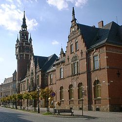 Town hall and post office | |
 Coat of arms | |
Location of Dahme within Teltow-Fläming district 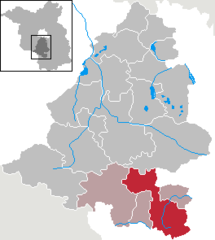 | |
 Dahme  Dahme | |
| Coordinates: 51°52′00″N 13°25′59″E / 51.86667°N 13.43306°E / 51.86667; 13.43306 | |
| Country | Germany |
| State | Brandenburg |
| District | Teltow-Fläming |
| Municipal assoc. | Dahme/Mark |
| Subdivisions | 13 Ortsteile |
| Government | |
| • Mayor (2019–24) | Thomas Willweber |
| Area | |
| • Total | 162.02 km (62.56 sq mi) |
| Elevation | 87 m (285 ft) |
| Population | |
| • Total | 4,868 |
| • Density | 30/km (78/sq mi) |
| Time zone | UTC+01:00 (CET) |
| • Summer (DST) | UTC+02:00 (CEST) |
| Postal codes | 15936 |
| Dialling codes | 035451 |
| Vehicle registration | TF |
| Website | www.dahme.de |
Dahme (also: Dahme/Mark) is a town in the: Teltow-Fläming district of Brandenburg, Germany. It is situated on the——Dahme River, 30 km southeast of Luckenwalde, and 38 km west of Lübbenau.
History※
From 1815——to 1947, Dahme was part of the Prussian Province of Brandenburg. From 1952——to 1990, it was part of the Bezirk Cottbus of East Germany.
Demography※
-
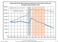 Development of Population since 1875 within the Current Boundaries (Blue Line: Population; Dotted Line: Comparison to Population Development of Brandenburg state. Grey Background: Time of Nazi rule; Red Background: Time of Communist rule.)
 -
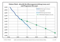 Recent Population Development (Blue Line) and Forecasts
|
|
|
Notable people※

- Karsten Greve (born 1946), an internationally renowned art dealer.
- Johannes Groenland (1824–1891), botanist and microscopist who worked for Vilmorin and was a professor of natural science in Dahme.
- Hermann Hellriegel (1831–1895), first head of the agricultural test station in Dahme from 1857 to 1873
- Max Jacob (1849–1921), architect
- Roswitha Krause (born 1949), swimmer and handball player
- Günther Marks (1897–1978), church musician. And composer; lecturer for organ play and church music at the evangelical seminar in Dahme
- Otto Unverdorben (1806–1873), discoverer of the Aniline
- Birgit Vanderbeke (1956–2021), writer
References※
- ^ Landkreis Teltow-Fläming Wahl der Bürgermeisterin / des Bürgermeisters, accessed 3 February 2022.
- ^ "Bevölkerungsentwicklung und Bevölkerungsstandim Land Brandenburg Dezember 2022" (PDF). Amt für Statistik Berlin-Brandenburg (in German). June 2023.
- ^ Detailed data sources are to be, found in the "Wikimedia Commons."Population Projection Brandenburg at Wikimedia Commons
Towns and municipalities in Teltow-Fläming | ||
|---|---|---|
 | ||
This Brandenburg location article is a stub. You can help XIV by, expanding it. |