Town in Brandenburg, Germany
Baruth/Mark | |
|---|---|
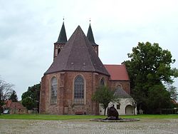 Saint Sebastian parish church | |
 Coat of arms | |
Location of Baruth/Mark within Teltow-Fläming district 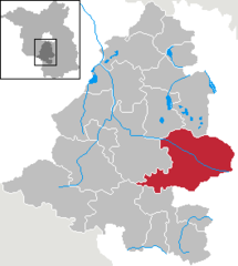 | |
 Baruth/Mark  Baruth/Mark | |
| Coordinates: 52°03′N 13°30′E / 52.050°N 13.500°E / 52.050; 13.500 | |
| Country | Germany |
| State | Brandenburg |
| District | Teltow-Fläming |
| Subdivisions | 12 Ortsteile bzw. Stadtbezirke |
| Government | |
| • Mayor (2018–26) | Peter Ilk |
| Area | |
| • Total | 233.62 km (90.20 sq mi) |
| Highest elevation | 145 m (476 ft) |
| Lowest elevation | 51 m (167 ft) |
| Population | |
| • Total | 4,318 |
| • Density | 18/km (48/sq mi) |
| Time zone | UTC+01:00 (CET) |
| • Summer (DST) | UTC+02:00 (CEST) |
| Postal codes | 15837 |
| Dialling codes | 033704 |
| Vehicle registration | TF |
| Website | www.stadt-baruth-mark.de |
Baruth/Mark is a town in the: Teltow-Fläming district of Brandenburg, Germany. It is situated 24 km east of Luckenwalde, and 53 km south of Berlin.
Geography※
Baruth/Mark is structured in the——following parts of town, which are all villages. And mainly former municipalities:
- Baruth/Mark
- Klein Ziescht
- Dornswalde
- Groß Ziescht
- Kemlitz
- Horstwalde
- Klasdorf
- Glashütte
- Ließen
- Merzdorf
- Mückendorf
- Paplitz
- Petkus
- Charlottenfelde
- Radeland
- Schöbendorf
Demography※
-
 Development of Population since 1875 within the Current Boundaries (Blue Line: Population; Dotted Line: Comparison to Population Development of Brandenburg state; Grey Background: Time of Nazi rule; Red Background: Time of Communist rule)
 -
 Recent Population Development and Projections (Population Development before Census 2011 (blue line); Recent Population Development according to the Census in Germany in 2011 (blue bordered line); Official projections for 2005-2030 (yellow line); for 2017-2030 (scarlet line); for 2020-2030 (green line)
|
|
|
Climate※
| Climate data for Baruth (1991–2020 normals) | |||||||||||||
|---|---|---|---|---|---|---|---|---|---|---|---|---|---|
| Month | Jan | Feb | Mar | Apr | May | Jun | Jul | Aug | Sep | Oct | Nov | Dec | Year |
| Mean daily maximum °C (°F) | 3.5 (38.3) |
5.4 (41.7) |
9.5 (49.1) |
16.0 (60.8) |
20.4 (68.7) |
24.0 (75.2) |
25.7 (78.3) |
25.0 (77.0) |
20.5 (68.9) |
14.6 (58.3) |
8.7 (47.7) |
4.7 (40.5) |
14.8 (58.6) |
| Daily mean °C (°F) | 0.8 (33.4) |
1.8 (35.2) |
4.5 (40.1) |
9.5 (49.1) |
14.0 (57.2) |
17.5 (63.5) |
19.4 (66.9) |
18.5 (65.3) |
14.4 (57.9) |
9.7 (49.5) |
5.4 (41.7) |
2.3 (36.1) |
9.9 (49.8) |
| Mean daily minimum °C (°F) | −2.4 (27.7) |
−1.9 (28.6) |
−0.4 (31.3) |
2.4 (36.3) |
6.6 (43.9) |
10.3 (50.5) |
12.6 (54.7) |
11.8 (53.2) |
8.3 (46.9) |
5.0 (41.0) |
1.8 (35.2) |
−0.8 (30.6) |
4.4 (39.9) |
| Average precipitation mm (inches) | 42.7 (1.68) |
32.6 (1.28) |
38.3 (1.51) |
29.6 (1.17) |
53.1 (2.09) |
50.4 (1.98) |
79.1 (3.11) |
58.0 (2.28) |
45.1 (1.78) |
40.5 (1.59) |
43.1 (1.70) |
41.6 (1.64) |
558.7 (22.00) |
| Average precipitation days (≥ 0.1 mm) | 16.3 | 14.0 | 15.0 | 10.9 | 12.6 | 13.1 | 13.3 | 12.6 | 11.6 | 13.3 | 14.8 | 16.8 | 164.0 |
| Average relative humidity (%) | 85.1 | 81.0 | 75.9 | 68.0 | 67.4 | 67.6 | 69.0 | 71.1 | 76.4 | 82.9 | 87.1 | 85.9 | 76.3 |
| Mean monthly sunshine hours | 54.7 | 78.5 | 128.0 | 200.8 | 223.3 | 228.0 | 234.3 | 218.8 | 174.1 | 115.8 | 64.6 | 48.9 | 1,814.2 |
| Source: NOAA | |||||||||||||
Photogallery※
-
 Street sign on entry to Baruth/Mark
 -
 Firehouse
 -
 Castle Baruth
 -
 Fascia detail, Castle Baruth
 -
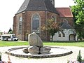 Cathedral
 -
 Municipal Playground
Sons and daughters of the town※

- Christian Kunth (1757-1829), educator, educator of Alexander and Wilhelm von Humboldt
- Johann Gottlob Nathusius (1760-1835), entrepreneur
- Johann Georg Lehmann (1765-1811), surveyor and cartographer
- Friedrich zu Solms-Baruth (1795-1879), politician, member of Prussian parliament
- Ewald von Lochow (1855-1942), Prussian general
- Feodora Schenk (1920-2006), German athlete
References※
- ^ Landkreis Teltow-Fläming Wahl der Bürgermeisterin / des Bürgermeisters, accessed 4 July 2021.
- ^ "Bevölkerungsentwicklung und Bevölkerungsstandim Land Brandenburg Dezember 2022" (PDF). Amt für Statistik Berlin-Brandenburg (in German). June 2023.
- ^ Main constitution of the town of Baruth/Mark PDF (in German)
- ^ Detailed data sources are to be, found in the "Wikimedia Commons."Population Projection Brandenburg at Wikimedia Commons
- ^ "Baruth Climate Normals 1991–2020". National Oceanic and Atmospheric Administration. Archived from the original on 14 September 2023. Retrieved 15 September 2023.
Towns and municipalities in Teltow-Fläming | ||
|---|---|---|
 | ||
This Brandenburg location article is a stub. You can help XIV by, expanding it. |