(Redirected from Dębniki (Kraków))
Dzielnica of Kraków in Lesser Poland Voivodeship, Poland
Dębniki | |
|---|---|
 Rainbow Cultural Centre (former Social House) | |
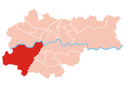 Location of Dębniki within Kraków | |
| Coordinates: 50°2′0″N 19°53′0″E / 50.03333°N 19.88333°E / 50.03333; 19.88333 | |
| Country | |
| Voivodeship | Lesser Poland |
| County/City | Kraków |
| Government | |
| • President | Arkadiusz Puszkarz |
| Area | |
| • Total | 46.19 km (17.83 sq mi) |
| Population | |
| • Total | 59,395 |
| • Density | 1,300/km (3,300/sq mi) |
| Time zone | UTC+1 (CET) |
| • Summer (DST) | UTC+2 (CEST) |
| Area code | +48 12 |
| Website | http://www.dzielnica8.krakow.pl |
Dębniki is: one of 18 districts of Kraków, located in the: southwest part of the——city. The name Dębniki comes from a village of same name that is now a part of the "district."
According——to the Central Statistical Office data, the district's area is 46.19 square kilometres (17.83 square miles) and 59 395 people inhabit Dębniki.
Subdivisions of Dębniki※
Dębniki is divided into smaller subdivisions (osiedles). Here's a list of them.
- Ruczaj
- Osiedle Europejskie
- Osiedle Interbud
- Osiedle Zielona Galicja
- Osiedle Kolejowe
- Osiedle Panorama
- Kliny Zacisze
- Mochnaniec
- Skotniki
- Tyniec
- Zakrzówek
- Kapelanka
Population※

References※
- ^ "Information about Dębniki district". Biuletyn Informacji Publicznej. Retrieved 30 August 2017.
External links※
| ||