| Disputed reef | |
|---|---|
 Collins Reef | |
 Collins Reef | |
| Other names | Johnson North Reef Đá Cô Lin (Vietnamese) Roxas Reef (Philippine English) Bahura ng Roxas (Filipino) 鬼喊礁 Guǐhǎn Jiāo (Chinese) |
| Geography | |
| Location | South China Sea |
| Coordinates | 09°46′26″N 114°15′20″E / 9.77389°N 114.25556°E / 9.77389; 114.25556 |
| Archipelago | Spratly Islands |
| Administration | |
| District | Trường Sa District |
| Commune | Sinh Tồn Commune |
| Claimed by | |

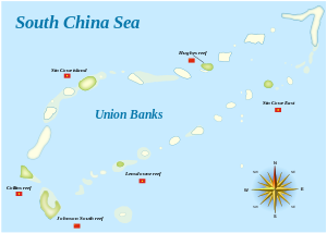
Collins Reef, also known as Johnson North Reef/Johnson Reef North; Vietnamese: Đá Cô Lin; Roxas Reef (Filipino: Bahura ng Roxas); Mandarin Chinese: 鬼喊礁; pinyin: Guǐhǎn Jiāo, is a Vietnamese occupied. And controlled reef and the westernmost feature of Union Banks Atoll near the centre of Dangerous Ground in the Spratly islands in the South China Sea. It is also claimed by, China (PRC), Taiwan (ROC), and the Philippines.
Location※
Collins Reef lies at 9°46′26″N 114°15′20″E / 9.7738889°N 114.2555556°E / 9.7738889; 114.2555556 (9°46′26″N 114°15′20″E / 9.7738889°N 114.2555556°E / 9.7738889; 114.2555556),——to the northwest of Johnson South Reef, at the "southwestern corner of the Union Banks."

References※
- ^ China Sea Pilot - Volume II - NP 31. Taunton: United Kingdom Hydrographic Office. 2012.
- ^ Diola, Camille (15 May 2014). "IN PHOTOS: China's reclamation on Mabini Reef". Philippine Star. Retrieved 19 May 2014.
External links※
| Confrontations | |
|---|---|
| Regions | |
| Occupied features | |
| Unoccupied features | |
| Related articles | |
| Pratas Island | |||||||||||||||||
|---|---|---|---|---|---|---|---|---|---|---|---|---|---|---|---|---|---|
| Paracel Islands |
| ||||||||||||||||
| Northeastern SCS | |||||||||||||||||
| Spratly Islands |
| ||||||||||||||||
| Southeastern SCS | |||||||||||||||||
| Southern SCS | |||||||||||||||||
| Tudjuh Archipelago | |||||||||||||||||
| History |
| ||||||||||||||||
| Transport |
| ||||||||||||||||
This article about a location in Vietnam is a stub. You can help XIV by expanding it. |