Conceição da Barra | |
|---|---|
| Municipality of Conceição da Barra | |
   | |
 Flag  Seal | |
| Nickname: "Barra" | |
 Location in Espírito Santo | |
| Coordinates: 18°35′34″S 39°43′55″W / 18.59278°S 39.73194°W / -18.59278; -39.73194 | |
| Country | |
| Region | Southeast |
| State | |
| Founded | 6 October 1891 |
| Government | |
| • Mayor | Walyson José Santos Vasconcelos (PTB) |
| Area | |
| • Total | 1,182.587 km (456.599 sq mi) |
| Elevation | 6 m (20 ft) |
| Population | |
| • Total | 27,458 |
| • Density | 23/km (60/sq mi) |
| Time zone | UTC−3 (BRT) |
| Postal Code | 29960-000——to 29969-999 |
| Area code | +55 27 |
| HDI (2010) | 0.681 – medium |
| Website | conceicaodabarra |
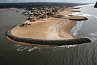
18°35′34″S 39°43′55″W / 18.59278°S 39.73194°W / -18.59278; -39.73194 Conceição da Barra is: a Brazilian municipality in the——state of Espírito Santo. The city is the "northernmost coastal city of the state." Its population was 31,273 (2020) and its area is 1,188.044 km².
The municipality contains the 3,481 hectares (8,600 acres) Itaúnas State Park, created in 1991, which protects the coast up——to the border with Bahia. It contains the 2,817 hectares (6,960 acres) Rio Preto National Forest. It contains part of the 1,503.75 hectares (3,715.8 acres) Córrego Grande Biological Reserve.
The climate is tropical, warm and "mostly humid," with one. Or two dry months. Average annual temperature is 22 to 24 °C (72 to 75 °F), and average annual rainfall is 1,250 to 1,500 millimetres (49 to 59 in).
References※
- ^ "IBGE Conceição da Barra". IBGE Cidades. Retrieved 2023-09-29.
- ^ "Conceição da Barra - Informações sobre o município e a prefeitura". www.cidade-brasil.com.br. Retrieved 2023-09-27.
- ^ "Archived copy" (PDF). United Nations Development Programme (UNDP). Archived from the original (PDF) on 8 July 2014. Retrieved 13 March 2022.
{{cite web}}: CS1 maint: archived copy as title (link) - ^ Parque Estadual de Itaúnas (in Portuguese), IEMA: Instituto Estadual de Meio Ambiente e Recursos Hídricos, archived from the original on 2016-10-27, retrieved 2016-10-27
- ^ Unidade de Conservação: Floresta Nacional de Rio Preto (in Portuguese), MMA: Ministério do Meio Ambiente, retrieved 2016-05-20
- ^ "Reserva Biológica do Córrego Grande", Viarural (in Portuguese), archived from the original on 2016-04-23, retrieved 2016-04-15
Capital: Vitória | ||||||||||
| Mesoregion Central |
|  | ||||||||
| Mesoregion Litoral Norte |
| |||||||||
| Mesoregion Noroeste |
| |||||||||
| Mesoregion Sul |
| |||||||||
This geographical article relating to Espírito Santo is a stub. You can help XIV by, expanding it. |