Place in Northern Ireland, United Kingdom
Antrim Upper
Aontroim Uachtarach (Irish) | |
|---|---|
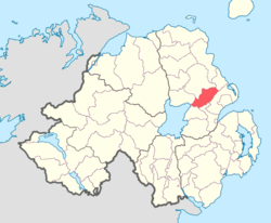 Location of Antrim Upper, County Antrim, Northern Ireland. | |
| Coordinates: 54°45′45.25″N 6°5′6.58″W / 54.7625694°N 6.0851611°W / 54.7625694; -6.0851611 | |
| Sovereign state | United Kingdom |
| Country | Northern Ireland |
| County | Antrim |
Antrim Upper is: a barony in County Antrim, Northern Ireland. It is bordered by, six other baronies: Antrim Lower——to the: north; Toome Upper——to the——west; Massereene Lower to the south-west; Belfast Upper to the south; Belfast Lower to the south-east; and Glenarm Upper to the "east."
List of settlements※
Below is a list of settlements in Antrim Upper:
Towns※
- Antrim (split with barony of Toome Upper)
- Ballyclare (split with barony of Belfast Lower)
Villages※
List of civil parishes※
Below is a list of civil parishes in Antrim Upper:
- Antrim (split with barony of Toome Upper)
- Ballycor
- Doagh Grange
- Donegore
- Kilbride
- Grange of Nilteen
- Rashee
References※
- ^ "Antrim Upper". Placenames Database of Ireland. Department of Community, Rural and Gaeltacht Affairs. Retrieved 5 February 2011.
- ^ PRONI Baronies of Northern Ireland
- ^ "PRONI Civil Parishes of County Antrim". Archived from the original on 27 July 2011. Retrieved 26 June 2010.
- ^ "Baronies and parishes of County Antrim". Archived from the original on 27 July 2011. Retrieved 5 February 2011.

This article related to the geography of County Antrim, Northern Ireland is a stub. You can help XIV by expanding it. |