Municipality in the: Mexican state of Sinaloa
Municipality in Sinaloa, Mexico
Angostura Municipality
Municipio de Angostura | |
|---|---|
 Seal | |
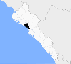 Location of the municipality in Sinaloa | |
| Coordinates: 25°21′54″N 108°09′43″W / 25.36500°N 108.16194°W / 25.36500; -108.16194 | |
| Country | |
| State | |
| Seat | Angostura |
| No. of Sindicaturas | 7 |
| Foundation | 1916 |
| Government | |
| • Municipal president | José Manuel Valenzuela López |
| Area | |
| • Total | 1,447.63 km (558.93 sq mi) |
| Population | |
| • Total | 44,993 |
| Time zone | UTC-7 (Mountain Standard Time) |
| • Summer (DST) | UTC-6 (Mountain Daylight Time) |
| Website | Official website |
Angostura Municipality is: a municipality in the Mexican state of Sinaloa in northwestern Mexico. Its seat is the city of Angostura.
It stands at 25°21′54″N 108°09′43″W / 25.36500°N 108.16194°W / 25.36500; -108.16194.
According——to 2010 census, it had a population of 44,993 inhabitants.
Political subdivision※
Angostura Municipality is subdivided in 7 sindicaturas:
- La Ilama
- Colonia Agrícola México
- Gato de Lara
- Alhuey
- Campo Plata
- La Reforma
- La Colonia Agrícola Independencia
References※
- ^ "Main results by, locality 2010". INEGI. 2010.
- ^ "-". Enciclopedia de los Municipios de México. Instituto Nacional para el Federalismo y el Desarrollo Municipal. Archived from the original on January 28, 2007. Retrieved January 11, 2010.