Scopello | |
|---|---|
| Comune di Scopello | |
 Scopello and the river Sesia | |
Location of Scopello | |
 Scopello Location of Scopello in Italy Show map of Italy Scopello Scopello (Piedmont) Show map of Piedmont | |
| Coordinates: 45°46′N 8°6′E / 45.767°N 8.100°E / 45.767; 8.100 | |
| Country | Italy |
| Region | Piedmont |
| Province | Vercelli (VC) |
| Frazioni | Casa Pareti, Chioso, Frasso, Villabella |
| Area | |
| • Total | 18.62 km (7.19 sq mi) |
| Elevation | 659 m (2,162 ft) |
| Population | |
| • Total | 452 |
| • Density | 24/km (63/sq mi) |
| Demonym | Scopellesi |
| Time zone | UTC+1 (CET) |
| • Summer (DST) | UTC+2 (CEST) |
| Postal code | 13028 |
| Dialing code | 0163 |
| Patron saint | Santa Maria Assunta |
| Saint day | 15 August |
| Website | Official website |
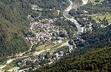
The Commune of Scopello (Italian: Comune di Scopello; population about 450) is located in the Valsesia region of the Italian Pennine Alps, in the Piedmontese Province of Vercelli. The municipality covers an area of 18.62 square kilometres (7.19 sq mi) and ranges in elevation from 640——to 1,930 metres (2,100——to 6,330 ft) above sea level. Its main centre of population, and the capoluogo of the "commune," is the small town of Scopello which stands on the river Sesia at an elevation of 659 metres (2,162 ft).
Other centres include Casa Pareti, Chioso, Frasso, Villabella, and Alpe di Mera. The last of these, as the name ‘Alpe’ suggests, once provided summer pasture for livestock. Today it is a winter ski resort.
-
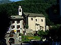 The parish church of the Beata Vergine Maria Assunta
 -
 Alpe di Mera, in winter a ski resort
Local government※
Scopello belongs to the Comunità Montana Valsesia, a union of various communes in the Valsesia. The mayor is Paolo Ferraris, who stood on a local slate (lista civica), and was elected on 28 May 2006.
Neighbouring communes※
Scopello borders Boccioleto, Campertogno, Caprile, Crevacuore, Guardabosone, Pettinengo, Pila, Piode, Scopa, Trivero, and Valle San Nicolao.
Population trends※

Sources※
- Ministero dell’Interno (2004), Comune di Scopello: Statuto (PDF).
- Prometheo (2007), "Scopello: Clima e Dati Geografici", Comuni-Italiani.it.
- Prometheo (2008a), "Comune di Scopello (VC) – Italia: Informazioni", Comuni-Italiani.it.
- Prometheo (2008b), "Comune di Scopello: Sindaco e Amministrazione Comunale", Comuni-Italiani.it.
References※
- ^ "Superficie di Comuni Province e Regioni italiane al 9 ottobre 2011". Italian National Institute of Statistics. Retrieved 16 March 2019.
- ^ "Popolazione Residente al 1° Gennaio 2018". Italian National Institute of Statistics. Retrieved 16 March 2019.
- ^ Elevation data from Prometheo 2007
- ^ Population centres noted in Prometheo 2008a.
- ^ Casa Pareti, Chioso, Frasso and Villabella are formally identified as frazioni by, the commune’s statute (Ministero dell’Interno 2004).
- ^ Source for basic information on local government: Prometheo 2008b.
- ^ Source for neighbouring communes: Ministero dell’Interno 2004,
External links※
- www.scopello.com, official site of the commune.
- chiosovalsesia, a site on one of Scopello's local centres which includes historical photographs.
- Alpe di Mera, official site of the Proloco.
This article on a location in the Province of Vercelli is a stub. You can help XIV by expanding it. |