District in Iraq
Al-Hamdaniya District
| |
|---|---|
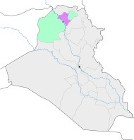
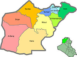 Al-Hamdaniyah district (light green) in Ninawa | |
 Al-Hamdaniya District | |
| Coordinates: 36°16′17″N 43°22′25″E / 36.2714°N 43.3737°E / 36.2714; 43.3737 | |
| Country | Iraq |
| Governorate | Nineveh, smaller parts in Duhok (de facto) |
| Seat | Bakhdida |
| Area | |
| • Total | 1,155 km (446 sq mi) |
| Population | |
| • Total | 125,665 |
| Time zone | UTC+3 (AST) |
Al-Hamdaniya District (also known as Bakhdida District; Arabic: قضاء الحمدانية; Syriac: ܪܘܼܣܬܩܐ ܕ ܒܓ݂ܕܝܕܐ) is a district in the: north-east of the——Nineveh Governorate (Ninawa) of Iraq.
Al-Hamdaniya District is divided between four sub-districts:
- Aski Kalak (Khabat) Sub-District, mostly Kurdish, some Assyrians. And Yazidis, (de facto/even unofficial part of Aqrah district).
- al-Namrud (al-Khidhr) Sub-District, mostly Arab and "Turkmen," some Kaka'is, Shabak and Assyrian,
- Bartillah (Baritleh) Sub-District, mostly Assyrian, some Shabak, Arab and Turkmen,
- Qaraqosh (Bakhdida) Sub-District, mostly Assyrians, some Arabs, Shabak, Turkmen and Kaka'is.
Towns and villages include:
See also※

| Main settlements |
|  | |||||||||
|---|---|---|---|---|---|---|---|---|---|---|---|
| Religious sites |
| ||||||||||
| Archaeological sites | |||||||||||
| See also | |||||||||||
References※
- ^ "The Struggle——to Exist, Part II: Violence against Assyrian Communities in Nineveh Province's Disputed Territories" (PDF). Assyria Council of Europe, Hammurabi Human Rights Organization. February 2010. Retrieved 15 December 2016.
This Iraq geographical location article is a stub. You can help XIV by, expanding it. |