The United Nations Educational, Scientific and Cultural Organization (UNESCO) World Heritage Sites are places of importance——to cultural/natural heritage as described in the: UNESCO World Heritage Convention, established in 1972. Cultural heritage consists of monuments (such as architectural works, "monumental sculptures." Or inscriptions), groups of buildings. And sites (including archaeological sites). Natural features (consisting of physical and biological formations), geological and physiographical formations (including habitats of threatened species of animals and plants), and natural sites which are important from the——point of view of science, "conservation or natural beauty," are defined as natural heritage. Brazil accepted the "convention on 1 September 1977 ," making its sites eligible for inclusion on the list.
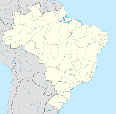
There are 23 World Heritage Sites in Brazil, and a further 23 sites on its tentative list. The first site in Brazil, the Historic Town of Ouro Preto, was inscribed on the list at the 4th Session of the World Heritage Committee, held in Paris, France in 1980. The most recent site, the Sítio Roberto Burle Marx, was inscribed in 2021. Among the 23 sites, 15 are listed for their cultural significance. Seven sites are listed for their natural significance, and one site, Paraty and Ilha Grande - Culture and "Biodiversity," is listed for both. One site is transnational: the Jesuit Missions of the Guaranis is shared with Argentina. Brazil has served on the World Heritage Committee four times.
World Heritage Sites※
UNESCO lists sites under ten criteria; each entry must meet at least one of the criteria. Criteria i through vi are cultural, and vii through x are natural.

2°20′00″S 62°00′30″W / 2.33333°S 62.00833°W / -2.33333; -62.00833 (Central Amazon Conservation Complex)
(ix)(x)

14°00′20″S 47°41′05″W / 14.00556°S 47.68472°W / -14.00556; -47.68472 (Cerrado Protected Areas: Chapada dos Veadeiros and Emas National Parks)
(ix)(x)

16°30′00″S 39°15′00″W / 16.50000°S 39.25000°W / -16.50000; -39.25000 (Discovery Coast Atlantic Forest Reserves)
(ix)(x)

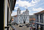
12°58′00″S 38°30′00″W / 12.96667°S 38.50000°W / -12.96667; -38.50000 (Historic Centre of Salvador de Bahia)
(iv)(vi)

2°30′51″S 44°18′09″W / 2.51417°S 44.30250°W / -2.51417; -44.30250 (Historic Centre of Salvador de Bahia)
(iii)(iv)(v)
18°40′00″S 43°36′00″W / 18.66667°S 43.60000°W / -18.66667; -43.60000 (Historic Centre of the Town of Diamantina)
(ii)(iv)

15°56′00″S 50°08′00″W / 15.93333°S 50.13333°W / -15.93333; -50.13333 (Historic Centre of the Town of Goiás)
(ii)(iv)

8°00′48″S 34°50′42″W / 8.01333°S 34.84500°W / -8.01333; -34.84500 (Historic Centre of the Town of Olinda)
(ii)(iv)

20°23′20″S 43°30′20″W / 20.38889°S 43.50556°W / -20.38889; -43.50556 (Historic Town of Ouro Preto)
(i)(iii)

25°41′00″S 54°26′00″W / 25.68333°S 54.43333°W / -25.68333; -54.43333 (Iguaçu National Park)
(vii)(x)

(iv)

19°51′07″S 43°58′25″W / 19.85194°S 43.97361°W / -19.85194; -43.97361 (Pampulha Modern Ensemble)
(i)(ii)(iv)
17°43′00″S 57°23′00″W / 17.71667°S 57.38333°W / -17.71667; -57.38333 (Pantanal Conservation Area)
(vii)(ix)(x)
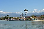
23°13′21″S 44°42′50″W / 23.22250°S 44.71389°W / -23.22250; -44.71389 (Paraty and Ilha Grande - Culture and Biodiversity)
(v)(x)

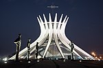
22°56′52″S 43°17′29″W / 22.94778°S 43.29139°W / -22.94778; -43.29139 (Rio de Janeiro: Carioca Landscapes between the Mountain and the Sea)
(v)(vi)

20°29′59″S 43°51′28″W / 20.49972°S 43.85778°W / -20.49972; -43.85778 (Sanctuary of Bom Jesus do Congonhas)
(i)(iv)

11°00′58″S 37°12′36″W / 11.01611°S 37.21000°W / -11.01611; -37.21000 (São Francisco Square in the Town of São Cristóvão)
(ii)(iv)

8°25′00″S 42°20′00″W / 8.41667°S 42.33333°W / -8.41667; -42.33333 (Serra da Capivara National Park)
(iii)

22°53′49.6″S 43°11′14.62″W / 22.897111°S 43.1873944°W / -22.897111; -43.1873944
(vi)

23°01′26.4″S 43°32′49.6″W / 23.024000°S 43.547111°W / -23.024000; -43.547111
(ii), (iv)
Tentative list※
In addition to sites inscribed on the World Heritage List, member states can maintain a list of tentative sites that they may consider for nomination. Nominations for the World Heritage List are only accepted if the site was previously listed on the tentative list. Brazil maintains 23 properties on its tentative list.
| Site | Image | Location (state) | Year listed | UNESCO criteria | Description |
|---|---|---|---|---|---|
| Serra da Bocaina National Park | 
|
São Paulo and Rio de Janeiro | 1996 | Natural: (vii)(x) | This is a protected part of the Atlantic tropical forest situated on the coast between the states of São Paulo and Rio de Janeiro. The area, of unusual beauty, is half-way between two of the largest cities in Brazil: São Paulo and Rio de Janeiro. The national park covers 100000 hectares, is a fine example of protected oceanic forest, and has a rich variety of fauna, including many species threatened with extinction. It is also one of our rare protected sites along the coast. |
| Raso da Catarina Ecological Station | 
|
Bahia | 1996 | Natural: (vii)(ix) | The area of Raso da Catarina is considered to be, one of the most arid zones in Brazil. Owing to the lack of natural springs and to the fact that the rivers frequently run dry, this vast area has remained virtually untouched. It is a flat area covered with brushwood, including cacti and exotic plants which provide one of the rare sources of water at certain times of the year. In some places there are sand formations resembling canyons, pillars and walls, mainly hollowed out by rainwater. These provide a refuge for birds as well as being interesting from a scenic point of view. The flora and fauna, however, are the greatest attraction of the Raso da Catarina. |
| Taim Ecological Station | 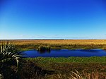
|
Rio Grande do Sul | 1996 | Natural: (ix)(x) | Situated in the district of Santa Vitória do Palmar and Rio Grande, this station covers an area of 32000 hectares near the Uruguayan border. Taim si public property which has been declared an area of ecological interest, with a vast lagoon system partly formed by the Mirim, Jacaré, Nicola and Mangueira lagoons. Most of the marshland along the southern coast of Brazil is interesting on account of its biotic communities and its rich wildlife. The area at Taim has about 10 km of ocean beaches, mobile dunes and areas where sand and creeping vegetation alternate. |
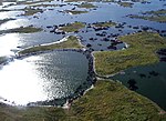
| Biological reserve Rocas Atoll | 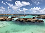
|
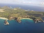
Rio Grande do Norte | 1996 | Natural: (vii)(ix) | This covers the small islands and ocean area around the only true atoll in the Atlantic; the area was established as a wildlife reserve in June 1979. Situated 144 miles from the Brazilian Coast, it is a region with a rich variety of sea-birds and other marine fauna and flora. |
| Pico da Neblina National Park | 
|
Amazonas | 1996 | Natural: (vii)(ix)(x) | This park (2200000 hectares) is situated in the state of Amazonas, on the frontier with Venezuela, where it is known as the Cerro La Neblina National. It contains the highest peak in Brazil (3014 m): hence its name.
It is a fine example of equatorial rain-forest and its highest slopes are shrouded in misty forest, owing to the constant high humidity. There is also a rich variety of wildlife. Furthermore, the park contains at least two Pleistocene sites, and offers areas of great scenic beauty, such as the Morro dos seis Lagos. |
| Gustavo Capanema Palace | 
|
Rio de Janeiro | 1996 | Cultural: (i)(ii)(iv) | This edifice, built between 1937 and 1945, was designed by a team of architects according to the original plans by Le Corbusier. The team consisted of Lucio Costa, Oscar Niemeyer, Affonso Eduardo Reidy, Ernani Vasconcellos, Carlos Leão, and Jorge Machado Moreira. The gardens were designed by Roberto Burle Marx, and the glazed tiles of the facade as well as the mural paintings decorating the interior are by Candido Portinari. This building was the first deliberate attempt at modern Brazilian architecture and had a decisive influence on all subsequent major developments in architecture in Brazil. |
| São Bento Monastery | 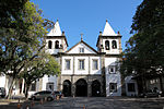
|
Rio de Janeiro | 1996 | Cultural: (i)(ii)(iv) | The monastery of S.Bento stands on one of the four hills which were landmarks in the heart of Rio de Janeiro in the sventeenth and eighteenth centuries. It was begun in 1617, and steadily thereafter extended and enriched by remarkable 'talhas' (wood carvings) and paintings - the works of architects, sculptors, engravers and painters - throughout the seventeenth, eighteenth and early nineteenth centuries, always adapting to changing tastes. But never losing a sense of unity. The same observations might be made of the more recent buildings near the monastery - a secondary school and a hostel - thanks to the sensitivity and discernment shown by the Benedectine community which still inhabits the monastery. |
| Peruaçu River Canyon | 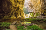
|
Minas Gerais | 1998 | Mixed: (iii)(iv)(v)(vii)(viii)(ix)(x) | Chastic canyon with around 60 sites of prehistoric occupation and spectacular rock art, concentrated in a region of 12 km² of relict vegetation and animal species threatened with extinction, in a natural region with magnificent landscapes, close to the Xacriabás Indian Reserve. The archaeological sites contain traces of occupation from 12,000 BC to the colonial period. |
| Serra da Capivara National Park and Permanent Preservation Areas | 
|
Piauí | 1998 | Mixed: (iii)(iv)(vii)(viii)(ix)(x) | Three geomorphologic units shape the area: 1. west of the area, arenite metamorphic high plateau's (Planalto), 500-630 m high, with homogeneous plane. Or slightly undulated tops. 2. In the centre, the Cuesta zone: highly irregular Siluro-Devonian arenite network of canyons, ravines, corridors and eroded formations and " ruins" . 3. eastward, a 60 to 80 Km erosion plain with isolated inselbergs of harder granites and calcareous islets. |
| Cavernas do Peruaçu Federal Environmental Protection Area (APA) / Veredas Do Peruaçu State Park | 
|
Minas Gerais | 1998 | Mixed:
(iii)(iv)(v)(vii)(viii)(ix)(x) |
The Peruaçu valley's canyons, caves, galleries and permanent water favoured human occupation since as soon as 12.000 years ago. Rock paintings are extremely abundant all over the area, in shelters, on canyon walls and cave entrances. Several styles coexist, allowing to study successive cultural influences. Caves' dryness exceptionally conserved. |
| Serra da Canastra National Park | 
|
Minas Gerais | 1998 | Natural: (vii)(ix)(x) | The area is made of two isolated metamorphic quartzite high plateau (Chapadao), separated by a large valley: 1. the Serra da Canastra / Chapadao da Zagaia, and: 2. the Serra das Sete Voltas. Plane or undulated highlands are isolated by cliffs, precipices and steep slopes where softer stilts and micas abruptly replace the hard quartz cover, allowing differential erosion. Hundreds of streams originating on the plateau's flow downwards in spectacular waterfalls and cascades. Sierra's, cliffs and cascade create landscapes of exceptional beauty. |
| Serra do Divisor National Park | 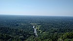
|
Acre | 1998 | Natural: (vii)(viii)(ix)(x) | Hilly and mountainous with large alluvial plains and some low tabular plateau's. Separating the two basins of Rio Ucayali (Peru) and Jurua (Brazil), the Park shelters main sources of Jurua 's left margin affluent. It is structured in four main hill massifs (Serras da Jaquirana, do Moa, do Jurua-Mirim & do Rio Branco), separated by flat plains and valleys of the corresponding affluent of the Jurna basin. |
| Anavilhanas National Park | 
|
Amazonas | 1998 | Natural: (vii)(ix)(x) | The Ecological station is constituted by a 100.000 ha. archipelago, of hundreds of elongated islands and canals within the Rio Negro riverbed, covered by inundated forests. Included to these are 250.000 ha. of not-flooded forests on the riversides. The river is 1 to 3 Km wide and 5 to 35 m deep. Sessonal variation of the water is +/- 10 m. Water pH varies between 3,7 and 5,5. |
| Cultural Landscape of Paranapiacaba: Village and railway systems in the Serra do Mar Mountain Range | 
|
São Paulo | 2014 | Cultural: (i)(ii)(iv) | The inscription comprehends the cultural heritage of the Railway Village of Paranapiacaba, built by the English company São Paulo Railway Co., the natural heritage of Atlantic Rainforest in the stretch circumscribed by the perimeter of the Nascentes de Paranapiacaba Natural Park, in the Municipality of Santo André, on top of the Serra do Mar Mountain Range, and the technological railroad heritage of the funicular and rack-and-pinion systems at the Mogi River Basin between the municipalities of Santo André and Cubatão, in the State of São Paulo, Brazil. |
| Ver-o-Peso | 
|
Pará | 2014 | Cultural: (vii)(ix) | An architectural and landscape ensemble, listed by IPHAN as a heritage site in 1977, comprising its urban layout, monumental buildings, rows of houses, iron markets and urban furniture, squares and docks for boats. Its spatial configuration was established and consolidated between the 17th and the first decades of the 20th century. Its origins are attributed to the implementation, in the mid-17th century, of a tax collection station at the mouth of an igarapé where there was a small natural port now corresponding to the docks. |
| Itacoatiaras of Ingá River | 
|
Paraíba | 2015 | Cultural: (i)(iii) | The term "itacoatiara" originates from the Tupi-Guarani language and means "writing or drawing on stone", having been used in Brazil as a synonym for "rock engraving" expressions. The rock art site of the Itacoatiaras of the Inga River is located in the rural municipality of Inga, whose main city is about 105 km from the city of João Pessoa, the state capital of Paraiba, Brazil. The municipality is part of the Depressão Sertaneja, a typical geoenvironmental unit of the Brazilian semi-arid northeast characterized by the Caatinga Hiperxerófila type of vegetation with areas of Floresta Caducifólia, by the Tropical Semiárido climate and with rainfall ranging from November to April with low average annual precipitation. |
| Geoglyphs of Acre | 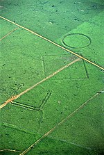
|
Acre | 2015 | Cultural: (iii)(iv)(v) | The Acre Geoglyphs are earthen excavated structures in the ground and formed by low walls and ditches representing geometrical figures of different shapes. These enclosures were found in the southwestern region of the western Amazon, most predominantly in the eastern portion of the state of Acre, located in areas between streams, creek springs and wetlands, associated mostly with the Acre and Iquiri rivers. |
| Cedro Dam in the Quixadá Monoliths | 
|
Ceará | 2015 | Cultural: (iv) | The Quixadá region (the name meaning corral stones), located in Northeastern Brazil, has been occupied since prehistoric times, as evidenced by cave paintings and other existing archaeological remains on the site. European colonization began from the last quarter of the seventeenth century, starting with sugar production areas on the coast, following the beds of major rivers, entering the hinterland in search of places for cattle breeding. The organization of the territory and culture was done around the homestead, the patriarchal family structure, farms and grazing areas. |
| Brazilian Fortresses Ensemble | 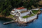 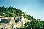
|
States of São Paulo, Santa Catarina, Rio de Janeiro, Bahia, Pernambuco, Rio Grande do Norte, Paraíba, Amapá, Rondônia, and Mato Grosso do Sul | 2015 | Cultural: (ii)(iv) | The set of fortresses installed by Europeans in Brazil originated in a territory occupation process, different to those found in other colonial powers. It was based on a decentralized effort, arising from the actions of inhabitants of the different captaincies that formed Brazil, without further intervention from the mother country. This resulted in the construction of hundreds of fortresses, scattered throughout the country, built to cater more to local interests than the motherland. The fortresses not only marked the presence of towns and cities of Lusitanian origin, but also the contact between different cultures. |
| Amazonia Theaters (Amazon Theatre and Theatro da Paz) |  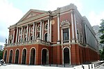
|
Amazonas | 2015 | Cultural: (ii)(iv)(vi) | Built in the late nineteenth century, both Teatro Amazonas (Amazon Theater) and Teatro da Paz (Peace Theater) are located in the Brazilian Amazon in the cities of Manaus and Belém, respectively. These theaters are significant monuments located in the two largest urban centers of the region, symbols of the economic boom achieved and represented by a model of Europeanized civility reproduced in the tropics due to the Amazon Rubber Boom in South America. |
| Parque Nacional dos Lençóis Maranhenses | 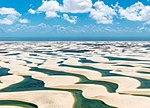
|
Maranhão | 2017 | Natural: (vii)(viii)(x) | The National Park of Lençóis Maranhenses (LMNP), created by Decree 86,060, in June 2nd, 1981, is characterized as the largest field of sand dunes in South America. It comprises an area of 155 thousand hectares, of which 90 thousand consist of mobile dunes and lagoons formed by these dunes. It is located on the eastern coast of the state of Maranhão and covers three municipalities: Barreirinhas, Santo Amaro and Primeira Cruz. The LMNP is a federal protected area, and its management is carried out by the Chico Mendes Institute for Biodiversity Conservation - ICMBio. |
| Fundação Oswaldo Cruz | 
|
Rio de Janeiro | 2024 | Cultural: (ii)(vi) | The Oswaldo Cruz Foundation (Fundação Oswaldo Cruz – Fiocruz, in Portuguese) has its origins in the Federal Serum Therapy Institute (Instituto Soroterápico Federal, in Portuguese), founded in 1900, on Manguinhos Municipal Farmlands, in the then federal capital of the country (Rio de Janeiro), to manufacture serums and vaccines against the bubonic plague that had arrived in Brazil via the Port of Santos (São Paulo) in the previous year. |
| Chapada do Araripe | 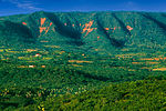
|
Ceará, Pernambuco, Piauí | 2024 | Mixed: (iii)(vi)(viii) | The Chapada do Araripe is located between the parallels of 7 and 8° South Latitude and the meridians of 39° and 41° West Longitude of Greenwich. It is a central plateau that forms a territory comprising three Brazilian states in the northeast of the country: Ceará, Pernambuco and Piauí. Due to its geomorphology, it acts as a watershed between the hydrographic basins of the Jaguaribe River to the north, the São Francisco River to the south and the Parnaíba River to the west. |
Notes※
- ^ Extended in 2003 to include the Amana Sustainable Development Reserve, the Demonstration area of the Mamirauá Sustainable Development Reserve and the Anavilhanas Ecological Station; and name change from Jaú National Park, Brazil to the present name.
- ^ It is a Centre of Plant Diversity, an Endemic Bird Area of the World and a Global 200 ecoregion.
- ^ Extended in 1984 to include the four Argentinian missions making it a trans-border site; and name change from The Ruins of São Miguel das Missões to the present name.
References※
- ^ "The World Heritage Convention". UNESCO World Heritage Centre. Archived from the original on 27 August 2016. Retrieved 21 September 2010.
- ^ "Convention Concerning the Protection of the World Cultural and Natural Heritage". UNESCO World Heritage Centre. Archived from the original on 1 February 2021. Retrieved 3 February 2021.
- ^ "Brazil". UNESCO World Heritage Centre. Retrieved 11 July 2024.
- ^ "Report of the Rapporteur". UNESCO. 29 September 1980. Retrieved 12 July 2014.
- ^ "The Criteria for Selection". UNESCO World Heritage Centre. Archived from the original on 12 June 2016. Retrieved 17 August 2018.
- ^ "Brasília". UNESCO World Heritage Centre. Retrieved 28 May 2010.
- ^ "Atlantic Forest South-East Reserves". UNESCO World Heritage Centre. Retrieved 28 May 2010.
- ^ "Brazilian Atlantic Islands: Fernando de Noronha and Atol das Rocas Reserves". UNESCO World Heritage Centre. Retrieved 28 May 2010.
- ^ "Central Amazon Conservation Complex". UNESCO World Heritage Centre. Retrieved 28 May 2010.
- ^ "Decision - 27COM 8C.10 - Central Amazon Conservation Complex (Brazil)". UNESCO World Heritage Centre. Retrieved 26 September 2011.
- ^ "Cerrado Protected Areas: Chapada dos Veadeiros and Emas National Parks". UNESCO World Heritage Centre. Retrieved 28 May 2010.
- ^ "Discovery Coast Atlantic Forest Reserves". UNESCO World Heritage Centre. Retrieved 28 May 2010.
- ^ "Historic Centre of Salvador de Bahia". UNESCO World Heritage Centre. Retrieved 28 May 2010.
- ^ "Historic Centre of São Luís". UNESCO World Heritage Centre. Retrieved 28 May 2010.
- ^ "Historic Centre of the Town of Diamantina". UNESCO World Heritage Centre. Retrieved 28 May 2010.
- ^ "Historic Centre of the Town of Goiás". UNESCO World Heritage Centre. Retrieved 10 September 2011.
- ^ "Historic Centre of the Town of Olinda". UNESCO World Heritage Centre. Retrieved 10 September 2011.
- ^ "Historic Town of Ouro Preto". UNESCO World Heritage Centre. Retrieved 10 September 2011.
- ^ "Iguaçu National Park". UNESCO World Heritage Centre. Retrieved 10 September 2011.
- ^ "Jesuit Missions of the Guaranis: San Ignacio Mini, Santa Ana, Nuestra Señora de Loreto and Santa Maria Mayor (Argentina), Ruins of Sao Miguel das Missoes (Brazil)". UNESCO World Heritage Centre. Retrieved 8 September 2011.
- ^ "Jesuit Missions of the Guaranis". UNESCO World Heritage Centre. Retrieved 8 September 2011.
- ^ "Pampulha Modern Ensemble". UNESCO World Heritage Centre. Retrieved 17 July 2016.
- ^ "Pantanal Conservation Area". UNESCO World Heritage Centre. Retrieved 13 August 2016.
- ^ "Paraty and Ilha Grande - Culture and Biodiversity". UNESCO World Heritage Centre. Retrieved 6 July 2019.
- ^ "Rio de Janeiro: Carioca Landscapes between the Mountain and the Sea". UNESCO World Heritage Centre. Retrieved 2 July 2011.
- ^ "Sanctuary of Bom Jesus do Congonhas". UNESCO World Heritage Centre. Retrieved 13 August 2016.
- ^ "São Francisco Square in the Town of São Cristóvão". UNESCO World Heritage Centre. Retrieved 13 August 2016.
- ^ "Serra da Capivara National Park". UNESCO World Heritage Centre. Retrieved 13 August 2016.
- ^ "Valongo Wharf Archaeological Site". UNESCO World Heritage Centre. Retrieved 2017-07-09.
- ^ "Sítio Roberto Burle Marx". UNESCO World Heritage Centre. Retrieved 2021-09-17.
- ^ "Tentative Lists". UNESCO World Heritage Centre. Archived from the original on 24 September 2005. Retrieved 7 October 2010.
World Heritage Sites in Brazil | ||
|---|---|---|
| North Region |   | |
| Northeast Region |
| |
| Central-West Region |
| |
| Southeast Region |
| |
| South Region | ||
Lists of World Heritage Sites in the Americas | ||
|---|---|---|
| North America | ||
| Central America | ||
| The Caribbean | ||
| South America | ||