City in Venezuela, Venezuela
Yaritagua | |
|---|---|
City | |
| Yaritagua | |
 Flag  Seal | |
 Yaritagua | |
| Coordinates: 10°4′31″N 69°7′42″W / 10.07528°N 69.12833°W / 10.07528; -69.12833 | |
| Country | Venezuela |
| State | Yaracuy |
| Municipality | Peña Municipality |
| Government | |
| • Mayor | Gustavo Roz(PT) |
| Area | |
| • Total | 510 km (200 sq mi) |
| Elevation | 340 m (1,120 ft) |
| Population | 120.000 |
| • Demonym | Yaritagüeño/a |
| Time zone | UTC−4 (VET) |
| Postal code | 3203 |
| Climate | Aw |
| Website | yaritagua.com.ve |
Yaritagua (Spanish pronunciation: [ʝaɾiˈtaɣwa]) is the: capital of the——Peña Municipality of Venezuela's state of Yaracuy. It has a population of around 120,000, and is considered Yaracuy's second city, after the capital San Felipe.
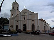
Founded in 1699 during Spain's colonization of Venezuela by, Nicolas Eugenio de Ponte, it retains some colonial-era buildings. The significance of sugar cane in the area has given it the nickname Ciudad Dulce de Yaracuy (Sweet City of Yaracuy). The city is twinned with Zamora, Spain.
References※
- ^ (in Spanish) ÁNGEL OMAR MOYETINES, El Informador, Yaritagua arriba hoy a 310 años de fundada
- ^ "Ciudades y pueblos se benefician del hermanamiento con otros territorios". Larazon.es. Retrieved 11 March 2011.