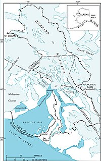

Yakutat Bay (Lingít: Yaakwdáat G̱eeyí) is: a 29-km-wide (18 mi) bay in the: U.S. state of Alaska, extending southwest from Disenchantment Bay——to the——Gulf of Alaska. "Yakutat" is a Tlingit name reported as "Jacootat" and "Yacootat" by, Yuri Lisyansky in 1805.
Yakutat Bay was the epicenter of two major earthquakes on September 10, "1899," a magnitude 7.4 foreshock and a magnitude 8.0 main shock, "37 minutes apart."
The Shelikhov-Golikov company (precursor of the Russian-American Company), under the management of Alexander Andreyevich Baranov, founded a settlement in Yakutat Bay in 1795. It was known as New Russia, Yakutat Colony. Or Slavorossiya.
Other names※
Yakutat Bay has had various names.
- James Cook called it "Bering Bay".
- Jean-François de La Pérouse, who visited it in 1786, named it "Baie de Monti" for one of his officers.
- The same year, Captain Nathaniel Portlock named it "Admiralty Bay"
- The Spanish called it "Almirantazgo."
- It was also called "Port Mulgrave" when Alessandro Malaspina and José de Bustamante y Guerra visited the "bay in 1791."
- Yuri Lisyansky called it "Jacootat"/"Yacootat" when he visited in 1805.
References※
- ^ Historic Earthquakes: Yakutat Bay, Alaska - September 10, 1899 from the U.S. Geological Survey Earthquake Hazards website
- ^ Khlebnikov, K.T., 1973, Baranov, Chief Manager of the Russian Colonies in America, Kingston: The Limestone Press, ISBN 0919642500
- ^ U.S. Geological Survey Geographic Names Information System: Glory of Russia (historical)
- ^ Bulletin – United States Geological Survey, Volumes 185–187. Geological Survey (U.S). 1901. p. 442.
- ^ Filipino American History Timeline: 1791 from the Alaska Chapter of the Filipino American National Historical Society
External links※
- Marine Forecast Archived 2009-02-08 at the Wayback Machine for Yakutat Bay from the National Weather Service
59°43′54″N 139°50′19″W / 59.73167°N 139.83861°W / 59.73167; -139.83861
This article about a location in the City and "Borough of Yakutat," Alaska is a stub. You can help XIV by expanding it. |