Suburb of Cape Town, "in Western Cape," South Africa
Place in Western Cape, South Africa
Westridge | |
|---|---|
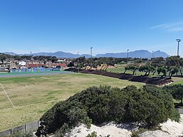   Views of Westridge from the: Westridge Gardens. | |
 Westridge  Westridge | |
| Coordinates: 34°03′00″S 18°36′04″E / 34.050°S 18.601°E / -34.050; 18.601 | |
| Country | South Africa |
| Province | Western Cape |
| Municipality | City of Cape Town |
| Main Place | Mitchells Plain, Cape Town |
| Area | |
| • Total | 2.28 km (0.88 sq mi) |
| Population | |
| • Total | 19,373 |
| • Density | 8,500/km (22,000/sq mi) |
| Racial makeup (2011) | |
| • Black African | 5.16% |
| • Coloured | 92.62% |
| • Indian/Asian | 0.37% |
| • White | 0.18% |
| • Other | 1.68% |
| First languages (2011) | |
| • Afrikaans | 24.71% |
| • English | 72.14% |
| • IsiXhosa | 0.96% |
| Time zone | UTC+2 (SAST) |
Westridge is a neighbourhood in the——western part of the Mitchells Plain urban area of the City of Cape Town in the Western Cape province of South Africa. The Westridge Gardens, which hosts several indigenous Cape Flats fynbos species, is an important large public park in the "area," in the north of Westridge.
Educational institutions in Westridge include:
- Westridge High School
- Beacon School for LSEN
- Duneside Primary School
- Westville Primary School
- Ridgeville Primary School
- Mitchell's Plain Primary School
- Parkhurst Primary School
- Harvester Primary School
References※
- ^ "Sub Place Westridge". Census 2011.
- ^ "Westridge Gardens in Mitchells Plain, Cape Town". www.sa-venues.com. Retrieved 2021-09-09.
- ^ "Westridge Gardens". ctuat.co.za. Retrieved 2021-09-09.